
ไฟล์:Habsburg Map 1547.jpg
ดูภาพที่มีความละเอียดสูงกว่า (1,654 × 1,029 พิกเซล, ขนาดไฟล์: 534 กิโลไบต์, ชนิดไมม์: image/jpeg)
| รูปภาพหรือไฟล์เสียงนี้ ต้นฉบับอยู่ที่ คอมมอนส์ รายละเอียดด้านล่าง เป็นข้อความที่แสดงผลจาก ไฟล์ต้นฉบับในคอมมอนส์
|
ความย่อ
| คำอธิบาย |
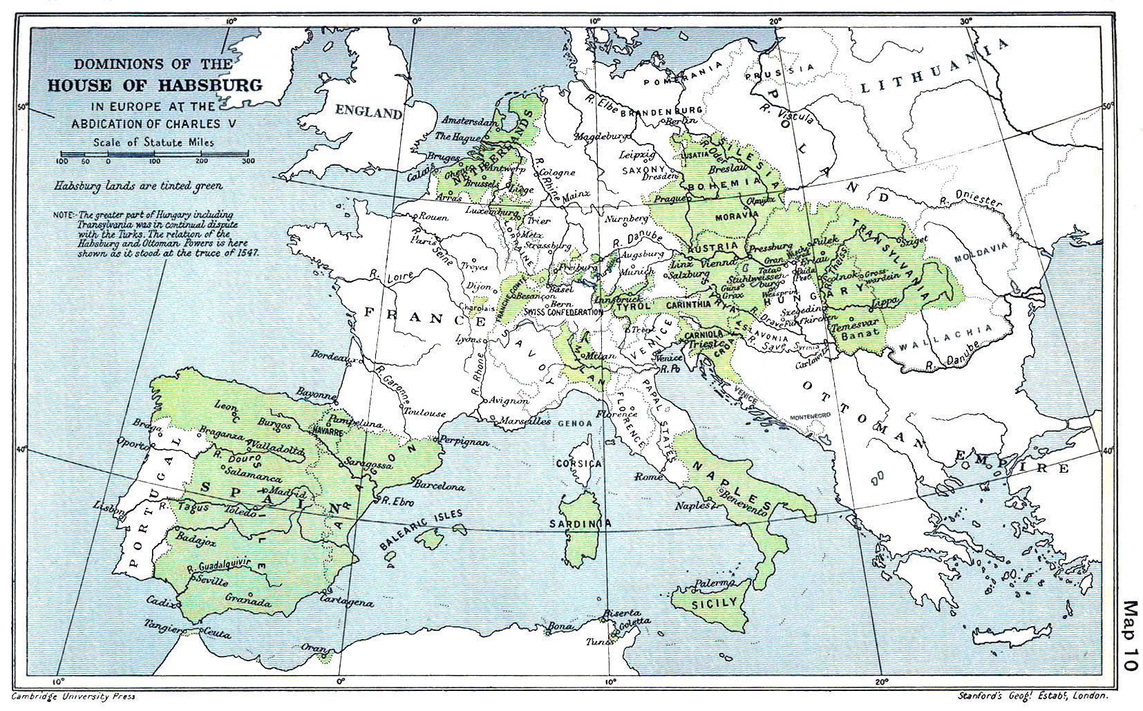
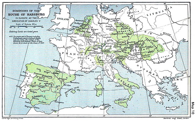
English: A map of the dominion of the Habsburgs following the Battle of Mühlberg (1547) |
| วันที่ | |
| แหล่งที่มา |
The Cambridge Modern History Atlas, edited by Sir Adolphus William Ward, G.W. Prothero, Sir Stanley Mordaunt Leathes, and E.A. Benians. Cambridge University Press: London, 1912. Editors were Sir Adolphus William Ward (†1924), G.W. Prothero (†1922), and Sir Stanley Mordaunt Leathes (†1938). Individual authors of works making up the atlas are not identified, nor are the likely to be, after reasonable research. |
| ผู้สร้างสรรค์ | edited by Sir Adolphus William Ward, G.W. Prothero, Sir Stanley Mordaunt Leathes |
| เวอร์ชันอื่น |
|

การอนุญาตใช้สิทธิ
งานนี้เป็นสาธารณสมบัติในสหรัฐอเมริกา เนื่องจากได้รับการเผยแพร่ (หรือขึ้นจดทะเบียนต่อสำนักงานลิขสิทธิ์แห่งสหรัฐ) ก่อนวันที่ 1 มกราคม ค.ศ. 1929
สาธารณสมบัติในผลงานนี้จะต้องเป็นทั้งในสหรัฐและประเทศต้นทางของงานดังกล่าว เพื่อให้สามารถที่จะจัดเก็บในคอมมอนส์ได้ หากงานดังกล่าวไม่ใช่ผลงานในสหรัฐ ไฟล์นั้นจึงจำเป็นต้องระบุป้ายระบุสถานะลิขสิทธิ์เพิ่มเติมสำหรับลิขสิทธิ์ในประเทศต้นทาง
|
This UK artistic or literary work, of which the author is unknown and cannot be ascertained by reasonable enquiry, is in the public domain because it is one of the following:
|
 |
ประวัติไฟล์
คลิกวันที่/เวลาเพื่อดูไฟล์ที่ปรากฏในขณะนั้น
| วันที่/เวลา | รูปย่อ | ขนาด | ผู้ใช้ | ความเห็น | |
|---|---|---|---|---|---|
| ปัจจุบัน | 16:20, 29 มีนาคม 2561 | | 1,654 × 1,029 (534 กิโลไบต์) | Trecătorul răcit | Little add: borders of the time |
| 18:01, 3 กันยายน 2558 |  | 1,654 × 1,029 (518 กิโลไบต์) | Kurzon | Reverted to version as of 17:22, 9 August 2010 | |
| 18:01, 3 กันยายน 2558 |  | 1,654 × 1,029 (518 กิโลไบต์) | Kurzon | Reverted to version as of 17:22, 9 August 2010 | |
| 04:33, 30 มิถุนายน 2556 |  | 1,654 × 1,029 (546 กิโลไบต์) | CSvBibra | add more contrast per request by another user | |
| 00:22, 10 สิงหาคม 2553 |  | 1,654 × 1,029 (518 กิโลไบต์) | CSvBibra | Previously put cleaned up version in new file with "b" after name. Now updating original file with "b" version. Both files uses throughout Wikipedias | |
| 16:07, 28 สิงหาคม 2551 |  | 1,654 × 1,029 (649 กิโลไบต์) | F l a n k e r | Wrap, shadows and minor improvements | |
| 21:42, 28 มิถุนายน 2548 |  | 1,654 × 1,029 (421 กิโลไบต์) | Rythin~commonswiki | A map of the dominion of the Habsburgs following the Battle of Mühlberg (1547). Taken from ''The Cambridge Modern History Atlas,'' edited by Sir Adolphus William Ward, G.W. Prothero, Sir Stanley Mordaunt Leathes, and E.A. Benians. Cambridge University Pr |
หน้าที่มีภาพนี้
หน้าต่อไปนี้ โยงมาที่ภาพนี้:
การใช้ไฟล์ข้ามโครงการ
วิกิอื่นต่อไปนี้ใช้ไฟล์นี้:
- การใช้บน af.wikipedia.org
- การใช้บน an.wikipedia.org
- การใช้บน ar.wikipedia.org
- การใช้บน arz.wikipedia.org
- การใช้บน ast.wikipedia.org
- การใช้บน azb.wikipedia.org
- การใช้บน ba.wikipedia.org
- การใช้บน be.wikipedia.org
- การใช้บน bg.wikipedia.org
- การใช้บน br.wikipedia.org
- การใช้บน bs.wikipedia.org
- การใช้บน ca.wikipedia.org
- การใช้บน cs.wikipedia.org
- การใช้บน da.wikipedia.org
- การใช้บน de.wikipedia.org
- การใช้บน el.wikipedia.org
ดูการใช้ข้ามโครงการเพิ่มเติมของไฟล์นี้