
ไฟล์:AchaemenidMapBehistunInscription.png

ขนาดของตัวอย่างนี้: 800 × 511 พิกเซล ความละเอียดอื่น: 320 × 205 พิกเซล | 640 × 409 พิกเซล | 1,020 × 652 พิกเซล
ดูภาพที่มีความละเอียดสูงกว่า (1,020 × 652 พิกเซล, ขนาดไฟล์: 17 กิโลไบต์, ชนิดไมม์: image/png)
| รูปภาพหรือไฟล์เสียงนี้ ต้นฉบับอยู่ที่ คอมมอนส์ รายละเอียดด้านล่าง เป็นข้อความที่แสดงผลจาก ไฟล์ต้นฉบับในคอมมอนส์
|
ความย่อ
| คำอธิบาย |
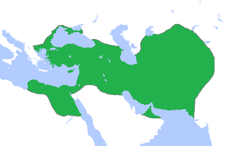
English: This a map of the Achaemenid Empire showing its greatest extent. I have given it more regions as listed on the Behistun Inscription the Persian King Darius wrote telling his conquests. |
| วันที่ | |
| แหล่งที่มา | http://en.wikipedia.org/wiki/File:Achemenids500BC.png |
| ผู้สร้างสรรค์ | Gabagool |
| การอนุญาต (การใช้ไฟล์นี้ใหม่) |
http://en.wikipedia.org/wiki/File:Achemenids500BC.png |
- Other information
English: This is a map I have edited from that map and it says that I am free to share, to remix, but under the following conditions that i must the work in the manner specified by the author or licensor.
ไฟล์นี้อยู่ภายใต้สัญญาอนุญาตครีเอทีฟคอมมอนส์ รุ่น แสดงที่มา 1.0 ทั่วไป
- คุณสามารถ:
- ที่จะแบ่งปัน – ที่จะทำสำเนา แจกจ่าย และส่งงานดังกล่าวต่อไป
- ที่จะเรียบเรียงใหม่ – ที่จะดัดแปลงงานดังกล่าว
- ภายใต้เงื่อนไขต่อไปนี้:
- แสดงที่มา – คุณต้องให้เกียรติเจ้าของงานอย่างเหมาะสม โดยเพิ่มลิงก์ไปยังสัญญาอนุญาต และระบุหากมีการเปลี่ยนแปลง คุณอาจทำเช่นนี้ได้ในรูปแบบใดก็ได้ตามควร แต่ต้องไม่ใช่ในลักษณะที่แนะว่าผู้ให้อนุญาตสนับสนุนคุณหรือการใช้งานของคุณ
การอนุญาตใช้สิทธิ
ไฟล์นี้อยู่ภายใต้สัญญาอนุญาตครีเอทีฟคอมมอนส์ รุ่น แสดงที่มา 3.0 ต้นฉบับ
- คุณสามารถ:
- ที่จะแบ่งปัน – ที่จะทำสำเนา แจกจ่าย และส่งงานดังกล่าวต่อไป
- ที่จะเรียบเรียงใหม่ – ที่จะดัดแปลงงานดังกล่าว
- ภายใต้เงื่อนไขต่อไปนี้:
- แสดงที่มา – คุณต้องให้เกียรติเจ้าของงานอย่างเหมาะสม โดยเพิ่มลิงก์ไปยังสัญญาอนุญาต และระบุหากมีการเปลี่ยนแปลง คุณอาจทำเช่นนี้ได้ในรูปแบบใดก็ได้ตามควร แต่ต้องไม่ใช่ในลักษณะที่แนะว่าผู้ให้อนุญาตสนับสนุนคุณหรือการใช้งานของคุณ
ประวัติไฟล์
คลิกวันที่/เวลาเพื่อดูไฟล์ที่ปรากฏในขณะนั้น
| วันที่/เวลา | รูปย่อ | ขนาด | ผู้ใช้ | ความเห็น | |
|---|---|---|---|---|---|
| ปัจจุบัน | 07:53, 23 ตุลาคม 2558 | | 1,020 × 652 (17 กิโลไบต์) | LouisAragon | blocked sock. |
| 09:01, 13 ตุลาคม 2558 |  | 1,020 × 652 (22 กิโลไบต์) | History of Persia | My apologies sir but they did conquer parts of arabia. See the Achaemenid Arabia article. | |
| 08:50, 13 ตุลาคม 2558 |  | 1,020 × 652 (17 กิโลไบต์) | LouisAragon | Reverted to version as of 22:39, 6 February 2015 (UTC) | |
| 08:24, 13 ตุลาคม 2558 |  | 1,020 × 652 (22 กิโลไบต์) | LouisAragon | correct. | |
| 08:21, 13 ตุลาคม 2558 |  | 1,020 × 652 (22 กิโลไบต์) | LouisAragon | They simply did not conquer those territories you just added on all sides. | |
| 06:28, 9 กันยายน 2558 |  | 1,012 × 648 (19 กิโลไบต์) | History of Persia | More accurate map. info on greek territories: File:Map Greco-Persian Wars-en.svg, size of Mascat (modern Oman/UAE): File:East-Hem 600bc.jpg. clay tablets in old persian have been found in bahrain, so its likely they were part of the achaemenid empire,... | |
| 07:48, 29 กรกฎาคม 2558 |  | 1,020 × 652 (20 กิโลไบต์) | History of Persia | made achaemenid arabia better | |
| 07:25, 9 กรกฎาคม 2558 |  | 1,020 × 652 (22 กิโลไบต์) | History of Persia | They had also conquered arabia-petrea (though it did not exist with that name) A wikipedia article of the province exists: Achaemenid Arabia | |
| 05:39, 7 กุมภาพันธ์ 2558 |  | 1,020 × 652 (17 กิโลไบต์) | HistoryofIran | I aprreciete your effort, but could you please upload the picture instead of replacing it with mine? thanks. | |
| 11:55, 29 มกราคม 2558 |  | 1,020 × 652 (59 กิโลไบต์) | Javierfv1212 | Updated the map by delineating the conquests of the three major Persian conqueror Kings, and also adding the names of the main satrapies of the empire. As a source I used this map of Ian Mladjov's Resources from the University of Michigan's History dep... |
หน้าที่มีภาพนี้
หน้าต่อไปนี้ โยงมาที่ภาพนี้:
การใช้ไฟล์ข้ามโครงการ
วิกิอื่นต่อไปนี้ใช้ไฟล์นี้:
- การใช้บน ar.wikipedia.org
- การใช้บน be.wikipedia.org
- การใช้บน da.wikipedia.org
- การใช้บน en.wikipedia.org
- การใช้บน en.wikivoyage.org
- การใช้บน eo.wikipedia.org
- การใช้บน es.wikipedia.org
- การใช้บน fa.wikipedia.org
- การใช้บน fr.wikipedia.org
- การใช้บน gl.wikipedia.org
- การใช้บน hu.wikipedia.org
- การใช้บน hy.wikipedia.org
- การใช้บน id.wikibooks.org
- การใช้บน incubator.wikimedia.org
- การใช้บน it.wikipedia.org
- การใช้บน it.wikiversity.org
- การใช้บน ja.wikipedia.org
- การใช้บน la.wikipedia.org
- การใช้บน li.wikipedia.org
- การใช้บน mg.wikipedia.org
- การใช้บน ms.wikipedia.org
- การใช้บน no.wikipedia.org
- การใช้บน pl.wikipedia.org
- การใช้บน pnb.wikipedia.org
- การใช้บน ps.wikipedia.org
- การใช้บน ru.wikipedia.org
- การใช้บน simple.wikipedia.org
- การใช้บน sr.wikipedia.org
- การใช้บน te.wikipedia.org
- การใช้บน tr.wikipedia.org
- การใช้บน tt.wikipedia.org
ดูการใช้ข้ามโครงการเพิ่มเติมของไฟล์นี้