
ไฟล์:Jugo-slavia, 1919.png

ดูภาพที่มีความละเอียดสูงกว่า (3,286 × 3,424 พิกเซล, ขนาดไฟล์: 3.02 เมกะไบต์, ชนิดไมม์: image/png)
| รูปภาพหรือไฟล์เสียงนี้ ต้นฉบับอยู่ที่ คอมมอนส์ รายละเอียดด้านล่าง เป็นข้อความที่แสดงผลจาก ไฟล์ต้นฉบับในคอมมอนส์
|
ความย่อ
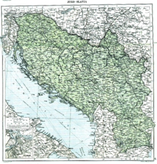
Map of Yugoslavia (Kingdom of Serbs, Croats and Slovenes) in 1919, in the aftermath of World War I, after the dissolution of Austria-Hungary and the incorporation of Montenegro and before the treaties of Neuilly-sur-Seine, Trianon and Rapallo. Published in 1920 by the London Geographical Institute (note that this map does not reflect any internationally established borders or armistice lines - it only reflects the opinion of the researchers from the London Geographical Institute about how the final borders will look after the Paris Peace Conference)
This uploaded map is a photoshopped version of the original image located at hipkiss.org. According to the site, there are no copyrights to this map.
การอนุญาตใช้สิทธิ
This image (or other media file) is in the public domain because its copyright has expired and its author is anonymous.
This applies to the European Union and those countries with a copyright term of 70 years after the work was made available to the public and the author never disclosed their identity. Important: Always mention where the image comes from, as far as possible, and make sure the author never claimed authorship. |
 | |
 |
Note: In Germany and possibly other countries, certain anonymous works published before July 1, 1995 are copyrighted until 70 years after the death of the author. See Übergangsrecht. Please use this template only if the author never claimed authorship or their authorship never became public in any other way. If the work is anonymous or pseudonymous (e.g., published only under a corporate or organization's name), use this template for images published more than 70 years ago.
For a work made available to the public in the United Kingdom, please use Template:PD-UK-unknown instead.
|
งานนี้เป็นสาธารณสมบัติในสหรัฐอเมริกา เนื่องจากได้รับการเผยแพร่ (หรือขึ้นจดทะเบียนต่อสำนักงานลิขสิทธิ์แห่งสหรัฐ) ก่อนวันที่ 1 มกราคม ค.ศ. 1929
สาธารณสมบัติในผลงานนี้จะต้องเป็นทั้งในสหรัฐและประเทศต้นทางของงานดังกล่าว เพื่อให้สามารถที่จะจัดเก็บในคอมมอนส์ได้ หากงานดังกล่าวไม่ใช่ผลงานในสหรัฐ ไฟล์นั้นจึงจำเป็นต้องระบุป้ายระบุสถานะลิขสิทธิ์เพิ่มเติมสำหรับลิขสิทธิ์ในประเทศต้นทาง
|
บันทึกการอัพโหลด
- 2008-07-03 23:29 Jklamo 3286×3424× (3168788 bytes) more photoshopped
- 2008-04-10 19:36 MaGioZal 3348×3500× (7196870 bytes) Map of [[Yugoslavia]] ([[Kingdom of Serbs, Croats and Slovenes]]) in [[1919]], showing the provisional borders in the [[aftermath of World War II]], after the dissolution of [[Austria-Hungary]] and the incorporation of [[Kingdom of Montenegro|Montenegro]]
ประวัติไฟล์
คลิกวันที่/เวลาเพื่อดูไฟล์ที่ปรากฏในขณะนั้น
| วันที่/เวลา | รูปย่อ | ขนาด | ผู้ใช้ | ความเห็น | |
|---|---|---|---|---|---|
| ปัจจุบัน | 07:12, 15 มกราคม 2555 | | 3,286 × 3,424 (3.02 เมกะไบต์) | OgreBot | (BOT): Reverting to most recent version before archival |
| 07:12, 15 มกราคม 2555 |  | 3,348 × 3,500 (6.86 เมกะไบต์) | OgreBot | (BOT): Uploading old version of file from en.wikipedia; originally uploaded on 2008-04-10 19:36:04 by MaGioZal | |
| 15:22, 27 พฤษภาคม 2554 |  | 3,286 × 3,424 (3.02 เมกะไบต์) | Tat1642 | ==Description== Map of Yugoslavia (Kingdom of Serbs, Croats and Slovenes) in 1919, in the aftermath of World War I, after the dissolution of Austria-Hungary and the incorporation of Montenegro and before the t |
หน้าที่มีภาพนี้
หน้าต่อไปนี้ โยงมาที่ภาพนี้:
การใช้ไฟล์ข้ามโครงการ
วิกิอื่นต่อไปนี้ใช้ไฟล์นี้:
- การใช้บน bn.wikipedia.org
- การใช้บน ca.wikipedia.org
- การใช้บน cs.wikipedia.org
- การใช้บน en.wikipedia.org
- การใช้บน et.wikipedia.org
- การใช้บน it.wikipedia.org
- การใช้บน ru.wikipedia.org
- การใช้บน sk.wikipedia.org
- การใช้บน vi.wikipedia.org