
ไฟล์:NATO Territory Map.svg

ขนาดของตัวอย่าง PNG นี้ของไฟล์ SVG นี้: 709 × 324 พิกเซล ความละเอียดอื่น: 320 × 146 พิกเซล | 640 × 292 พิกเซล | 1,024 × 468 พิกเซล | 1,280 × 585 พิกเซล | 2,560 × 1,170 พิกเซล
ดูภาพที่มีความละเอียดสูงกว่า ((ไฟล์ SVG, 709 × 324 พิกเซล, ขนาดไฟล์: 480 กิโลไบต์))
| รูปภาพหรือไฟล์เสียงนี้ ต้นฉบับอยู่ที่ คอมมอนส์ รายละเอียดด้านล่าง เป็นข้อความที่แสดงผลจาก ไฟล์ต้นฉบับในคอมมอนส์
|
ความย่อ
| คำอธิบาย |
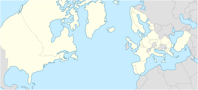
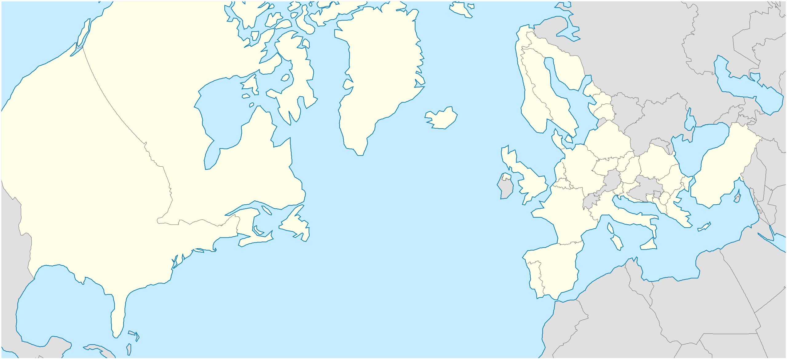
English: A geographical projection of a map that highlights all member nations of the North Atlantic Treaty Organization (NATO).
Nederlands: Een geografische projectie waarin het gebied van alle lidstaten van de Noord-Atlantische Verdrags Organisatie (NAVO) wordt belicht. |
| วันที่ | |
| แหล่งที่มา | งานของตัว - inspired by the work of Ssolbergj in File:NATO laea location map.svg. |
| ผู้สร้างสรรค์ | Woudsma |
| SVG genesis | ซอร์สโค้ดของ SVG นี้ตรวจสอบถูกต้องแล้ว ไฟล์ภาพกราฟิกส์เวกเตอร์นี้ สร้างขึ้นโดยใช้ Inkscape |
การอนุญาตใช้สิทธิ
ข้าพเจ้า ในฐานะผู้ถือลิขสิทธิ์ของภาพหรือสื่อนี้ อนุญาตให้ใช้ภาพหรือสื่อนี้ภายใต้เงื่อนไขต่อไปนี้
ไฟล์นี้อยู่ภายใต้สัญญาอนุญาต ครีเอทีฟคอมมอนส์ แบบแสดงที่มา-อนุญาตแบบเดียวกัน 4.0 นานาชาติ
- คุณสามารถ:
- ที่จะแบ่งปัน – ที่จะทำสำเนา แจกจ่าย และส่งงานดังกล่าวต่อไป
- ที่จะเรียบเรียงใหม่ – ที่จะดัดแปลงงานดังกล่าว
- ภายใต้เงื่อนไขต่อไปนี้:
- แสดงที่มา – คุณต้องให้เกียรติเจ้าของงานอย่างเหมาะสม โดยเพิ่มลิงก์ไปยังสัญญาอนุญาต และระบุหากมีการเปลี่ยนแปลง คุณอาจทำเช่นนี้ได้ในรูปแบบใดก็ได้ตามควร แต่ต้องไม่ใช่ในลักษณะที่แนะว่าผู้ให้อนุญาตสนับสนุนคุณหรือการใช้งานของคุณ
- อนุญาตแบบเดียวกัน – หากคุณดัดแปลง เปลี่ยนรูป หรือต่อเติมงานนี้ คุณต้องใช้สัญญาอนุญาตแบบเดียวกันหรือแบบที่เหมือนกับสัญญาอนุญาตที่ใช้กับงานนี้เท่านั้น
ประวัติไฟล์
คลิกวันที่/เวลาเพื่อดูไฟล์ที่ปรากฏในขณะนั้น
| วันที่/เวลา | รูปย่อ | ขนาด | ผู้ใช้ | ความเห็น | |
|---|---|---|---|---|---|
| ปัจจุบัน | 10:07, 9 มีนาคม 2567 | | 709 × 324 (480 กิโลไบต์) | Woudsma | Uploaded own work with UploadWizard |
หน้าที่มีภาพนี้
ไม่มีหน้าใดโยงมาที่ภาพนี้
การใช้ไฟล์ข้ามโครงการ
วิกิอื่นต่อไปนี้ใช้ไฟล์นี้:
- การใช้บน en.wikipedia.org
- NATO
- Incirlik Air Base
- Allied Command Operations
- Allied Command Transformation
- Joint Warfare Centre
- Template:Location map
- Template:Location map/doc
- NATO School
- Joint Force Training Centre
- Mürted Airfield Command
- Joint Analysis and Lessons Learned Centre
- Template:Location map/sandbox
- Çiğli Air Base
- Ankara Güvercinlik Army Air Base
- Etimesgut Air Base
- Cengiz Topel Naval Air Station
- Kütahya Air Base
- Allied Land Command
- Allied Maritime Command
- Naval Striking and Support Forces NATO
- Template:NATO commands
- Module:Location map/data/NATO
- Module:Location map/data/NATO/doc
- European Union–NATO relations
- User:Mgkrupa/Code and Symbols
- User:Woudsma/NATO Commands Map