
ไฟล์:WW2-Holocaust-Poland.PNG
ขนาดของตัวอย่างนี้: 557 × 600 พิกเซล ความละเอียดอื่น: 223 × 240 พิกเซล | 446 × 480 พิกเซล | 713 × 768 พิกเซล | 951 × 1,024 พิกเซล | 2,007 × 2,161 พิกเซล
ดูภาพที่มีความละเอียดสูงกว่า (2,007 × 2,161 พิกเซล, ขนาดไฟล์: 1.34 เมกะไบต์, ชนิดไมม์: image/png)
| รูปภาพหรือไฟล์เสียงนี้ ต้นฉบับอยู่ที่ คอมมอนส์ รายละเอียดด้านล่าง เป็นข้อความที่แสดงผลจาก ไฟล์ต้นฉบับในคอมมอนส์
|

|
ภาพแผนที่นี้ ควรจะถูกสร้างใหม่เป็นกราฟิกส์เวกเตอร์ ซึ่งมีข้อดีอีกหลายประการ ดูเพิ่มเติมที่คอมมอนส์:สื่อต้องการเก็บกวาดสำหรับสารสนเทศเพิ่มเติม หากภาพนี้มีในรูปแบบกราฟิกส์เวกเตอร์อยู่แล้ว กรุณาอัปโหลดและแทนที่แม่แบบนี้ด้วย
{{vector version available|ชื่อภาพใหม่}}
แนะนำเป็นอย่างยิ่งให้ตั้งชื่อไฟล์เวกเตอร์ใหม่นั้นในรูปแบบ "WW2-Holocaust-Poland.svg" แล้วใส่แม่แบบ Vector version available (หรือ Vva) ซึ่งไม่ต้องใช้พารามิเตอร์ ชื่อภาพใหม่ |
ความย่อ
| คำอธิบาย |
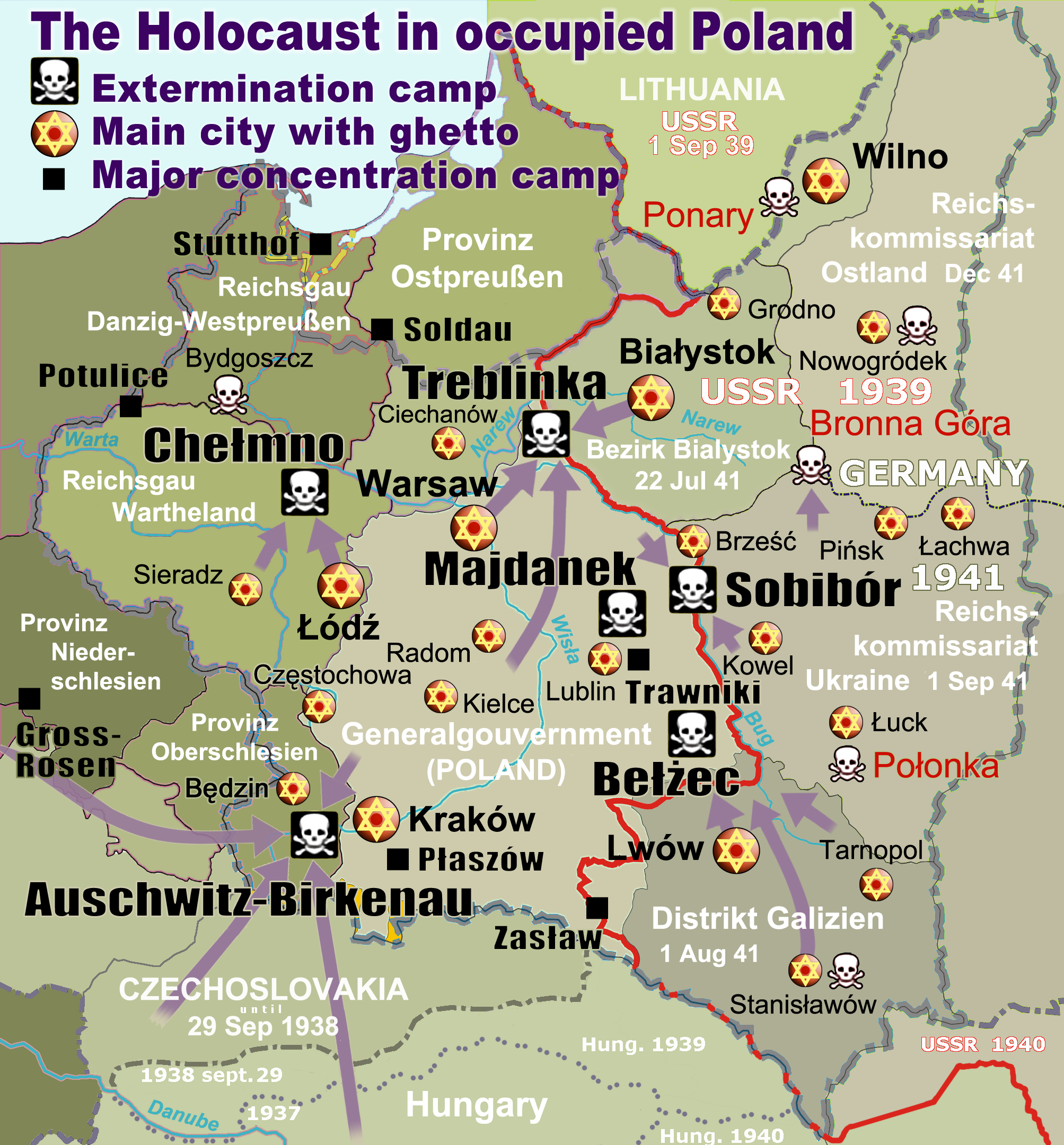
English: Map of the Holocaust in occupied Poland during World War II. The outline shows the borders of the Second Polish Republic at the time of the Nazi-German-and-Soviet invasion of Poland in 1939 with demarcation line between the two invading armies marked in red. Internal boundaries show the administrative divisions of occupied territories imposed by Nazi Germany when the Final Solution was set in motion during and after Operation Barbarossa of 1941. This map shows all Nazi German extermination camps (or death camps), as well as prominent concentration, labour and prison camps, major pre-WW2 Polish cities with the new Jewish ghettos set up by Nazi Germany, major deportation routes, and major massacre sites. Notes: 1. Extermination camps – marked with white skulls in black squares – are six dedicated facilities used for the mass gassings of prisoners, but all camps and ghettos took a toll of many, many lives. 2. Concentration camps – marked with black squares – feature only the most notorious forced-labor camps, prison camps & transit camps. 3. Sites of mass shootings into remote ravines – marked with white skulls – include Bronna Góra, Ponary and others. They were utilized during the 'Holocaust by bullets'. 4. Destruction ghettos – marked with Yellow stars in red circles – existed in most Polish cities. Only a selection is shown. 5. Major deportation routes travelled by the Holocaust trains are marked with RosyBrown arrows. 6. Most camps & ghettos which are not well known have been excluded for clarity. 7. District borders are at the height of Axis domination (1942). 8. Regions have German designations (e.g. "Ostland"), with the country name denoted in uppercase letters, e.g. LITHUANIA, CZECHOSLOVAKIA, or in parenthesis below the German occupational designation, e.g. (POLAND). |
| วันที่ | |
| แหล่งที่มา |
งานของตัว. Composite map derived from a variety of readily available sources which may or may not include:
|
| ผู้สร้างสรรค์ |
|
| การอนุญาต (การใช้ไฟล์นี้ใหม่) |
PD, see below. The map is completely unrestricted for any Wikipedia/Wikimedia project. |
| เวอร์ชันอื่น |
[]
|


.png)


.png)


การอนุญาตใช้สิทธิ
For all derivative works of maps uploaded earlier see below.
Poeticbent (en) ในฐานะผู้ถือลิขสิทธิ์ของภาพหรือสื่อนี้ อนุญาตให้ใช้ภาพหรือสื่อนี้ภายใต้เงื่อนไขต่อไปนี้
| ข้าพเจ้า ผู้ถือลิขสิทธิ์ในงานนี้ ขอมอบงานให้เป็นสาธารณสมบัติ ประกาศนี้มีผลทั่วโลก ในบางประเทศ การกระทำดังกล่าวอาจไม่สามารถทำได้ตามกฎหมาย ข้าพเจ้าอนุญาตให้ทุกคนมีสิทธิ์ในการใช้ไฟล์นี้ในทุกเหตุผลการใช้ โดยไม่มีมีเงื่อนไข เว้นแต่กฎหมายไม่อนุญาตให้ทำเช่นนั้น |
- File uploaded previously
Dennis Nilsson ในฐานะผู้ถือลิขสิทธิ์ของภาพหรือสื่อนี้ อนุญาตให้ใช้ภาพหรือสื่อนี้ภายใต้เงื่อนไขต่อไปนี้
ไฟล์นี้อยู่ภายใต้สัญญาอนุญาตครีเอทีฟคอมมอนส์ รุ่น แสดงที่มา 3.0 ต้นฉบับ
การแสดงที่มา: Dennis Nilsson
- คุณสามารถ:
- ที่จะแบ่งปัน – ที่จะทำสำเนา แจกจ่าย และส่งงานดังกล่าวต่อไป
- ที่จะเรียบเรียงใหม่ – ที่จะดัดแปลงงานดังกล่าว
- ภายใต้เงื่อนไขต่อไปนี้:
- แสดงที่มา – คุณต้องให้เกียรติเจ้าของงานอย่างเหมาะสม โดยเพิ่มลิงก์ไปยังสัญญาอนุญาต และระบุหากมีการเปลี่ยนแปลง คุณอาจทำเช่นนี้ได้ในรูปแบบใดก็ได้ตามควร แต่ต้องไม่ใช่ในลักษณะที่แนะว่าผู้ให้อนุญาตสนับสนุนคุณหรือการใช้งานของคุณ
Derivative work: Piotr Konieczny aka Prokonsul Piotrus Talk ไฟล์อื่นที่ใช้ไฟล์นี้:
Derivative work: User:Poeticbent (Talk) ไฟล์อื่นที่ใช้ไฟล์นี้:
- Uploaded previously
| ภาพนี้ ได้รับการปรับแต่งภาพ ซึ่งหมายความว่าจะได้รับการเปลี่ยนแปลงภาพต่างจากต้นฉบับ การปรับปรุง: Smaller version: occupied Poland only (pre-WWII borders). ต้นฉบับสามารถดูได้ที่นี่: WW2-Holocaust-Europe.png.
|
ข้าพเจ้า ในฐานะผู้ถือลิขสิทธิ์ของภาพหรือสื่อนี้ อนุญาตให้ใช้ภาพหรือสื่อนี้ภายใต้เงื่อนไขต่อไปนี้
ไฟล์นี้อยู่ภายใต้สัญญาอนุญาตครีเอทีฟคอมมอนส์ รุ่น แสดงที่มา 3.0 ต้นฉบับ
- คุณสามารถ:
- ที่จะแบ่งปัน – ที่จะทำสำเนา แจกจ่าย และส่งงานดังกล่าวต่อไป
- ที่จะเรียบเรียงใหม่ – ที่จะดัดแปลงงานดังกล่าว
- ภายใต้เงื่อนไขต่อไปนี้:
- แสดงที่มา – คุณต้องให้เกียรติเจ้าของงานอย่างเหมาะสม โดยเพิ่มลิงก์ไปยังสัญญาอนุญาต และระบุหากมีการเปลี่ยนแปลง คุณอาจทำเช่นนี้ได้ในรูปแบบใดก็ได้ตามควร แต่ต้องไม่ใช่ในลักษณะที่แนะว่าผู้ให้อนุญาตสนับสนุนคุณหรือการใช้งานของคุณ
บันทึกการอัพโหลด
For derivative works of the first uploaded file created by User:Dna-webmaster see the following:
- File:WW2-Holocaust-Europe.png licensed with Cc-by-3.0
Uploaded with derivativeFX
ประวัติไฟล์
คลิกวันที่/เวลาเพื่อดูไฟล์ที่ปรากฏในขณะนั้น
| วันที่/เวลา | รูปย่อ | ขนาด | ผู้ใช้ | ความเห็น | |
|---|---|---|---|---|---|
| ปัจจุบัน | 22:46, 10 มีนาคม 2563 | | 2,007 × 2,161 (1.34 เมกะไบต์) | Claude Zygiel | Cosmetics |
| 03:33, 29 มีนาคม 2561 |  | 2,007 × 2,161 (1.48 เมกะไบต์) | Poeticbent | not an improvement: img looks muddy but I have original Photoshop layers, and can adjust them individually; comment on specifics in talk please | |
| 00:48, 28 มีนาคม 2561 |  | 2,007 × 2,161 (1.49 เมกะไบต์) | Hohum | Too much information competing for attention in a very busy image. Toned down region name brightness, desaturated slightly. | |
| 12:38, 10 กรกฎาคม 2560 |  | 2,007 × 2,161 (1.48 เมกะไบต์) | Poeticbent | vital updates following a discussion → prominent ghettos, legend | |
| 02:43, 26 กรกฎาคม 2558 |  | 2,007 × 2,161 (1.46 เมกะไบต์) | Poeticbent | name of settlement: Górka Połonka, source Wolyn.ovh.org | |
| 01:27, 3 ธันวาคม 2557 |  | 2,007 × 2,161 (1.46 เมกะไบต์) | Poeticbent | added one missing marker | |
| 02:17, 8 พฤษภาคม 2557 |  | 2,007 × 2,161 (1.45 เมกะไบต์) | Poeticbent | location of Bronna Góra | |
| 00:34, 5 เมษายน 2557 |  | 2,007 × 2,161 (1.44 เมกะไบต์) | Poeticbent | Lachwa Ghetto location | |
| 04:31, 28 มิถุนายน 2556 |  | 2,007 × 2,161 (1.42 เมกะไบต์) | Poeticbent | major expansion with similar color-scheme | |
| 10:09, 28 มิถุนายน 2554 |  | 364 × 339 (123 กิโลไบต์) | LMK3 | changed the color of the Soviet Curzon line to indicate the two different occupation zones before Operation Barbarossa, refined the location of Warsaw |
หน้าที่มีภาพนี้
หน้าต่อไปนี้ โยงมาที่ภาพนี้:
การใช้ไฟล์ข้ามโครงการ
วิกิอื่นต่อไปนี้ใช้ไฟล์นี้:
- การใช้บน ar.wikipedia.org
- การใช้บน azb.wikipedia.org
- การใช้บน az.wikipedia.org
- การใช้บน bg.wikipedia.org
- การใช้บน bn.wikipedia.org
- การใช้บน br.wikipedia.org
- การใช้บน ca.wikipedia.org
- การใช้บน cs.wikipedia.org
- การใช้บน cs.wikibooks.org
- การใช้บน da.wikipedia.org
- การใช้บน de.wikipedia.org
- การใช้บน el.wikipedia.org
- Γκέτο της Τσενστοχόβα
- Γκέτο του Μπέντζιν
- Γκέτο του Μίζοτς
- Μπρόνα Γκούρα
- Γκέτο της Κρακοβίας
- Γκέτο του Μπζέσκο
- Στρατόπεδο συγκέντρωσης Τραβνίκι
- Στρατόπεδο συγκέντρωσης Ποτουλίτσε
- Γκέτο του Σοσνόβιετς
- Γκέτο του Ντροχόμπιτς
- Γκέτο του Ταρνόπολ
- Ιστορία των Εβραίων στην Πολωνία
- Γκέτο του Σιέντλτσε
- Γκέτο της Γουόμζα
- Γκέτο του Γκορλίτσε
- Γκέτο του Μπιαουίστοκ
- Γκέτο του Μπζεστς
- Γκέτο του Ράντομ
- Γκέτο του Νόβι Σοντς
ดูการใช้ข้ามโครงการเพิ่มเติมของไฟล์นี้