
ไฟล์:Trans Alaska Pipeline Denali fault shift.jpg
ขนาดของตัวอย่างนี้: 800 × 600 พิกเซล ความละเอียดอื่น: 320 × 240 พิกเซล | 640 × 480 พิกเซล | 1,024 × 768 พิกเซล | 1,280 × 960 พิกเซล | 2,560 × 1,920 พิกเซล
ดูภาพที่มีความละเอียดสูงกว่า (2,560 × 1,920 พิกเซล, ขนาดไฟล์: 570 กิโลไบต์, ชนิดไมม์: image/jpeg)
| รูปภาพหรือไฟล์เสียงนี้ ต้นฉบับอยู่ที่ คอมมอนส์ รายละเอียดด้านล่าง เป็นข้อความที่แสดงผลจาก ไฟล์ต้นฉบับในคอมมอนส์
|
ความย่อ
| คำอธิบาย |
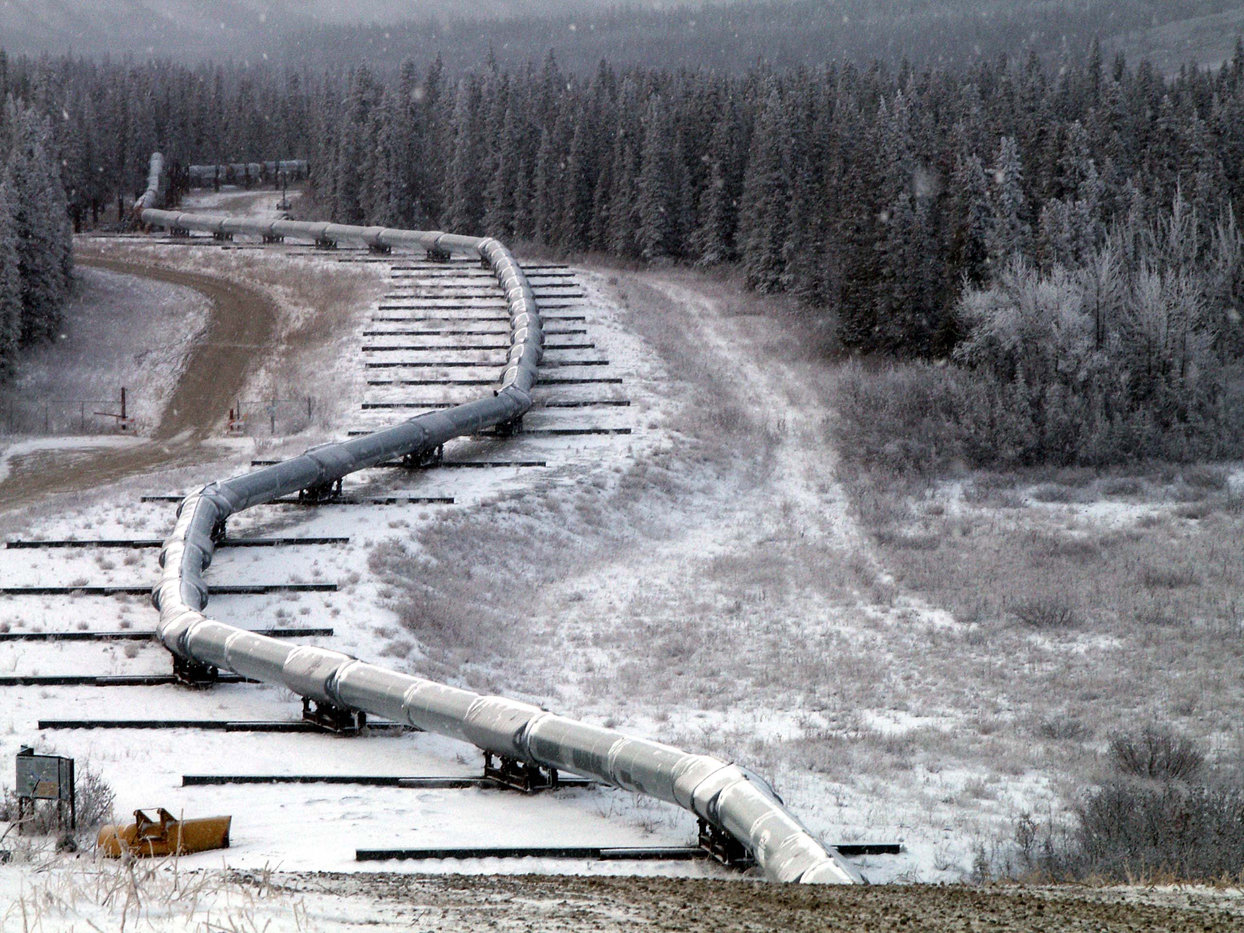
English: Trace of the Denali Fault after the 7.9 magnitude earthquake of 3 November 2002, Alaska, USA. View south along the Trans-Alaska Pipeline System in the zone where it was engineered to cross the fault (the pipeline rests on sliders rather than rigid pillar supports). The fault trace passes beneath the pipeline between the 2nd and 3rd slider supports at the far end of the zone. A large arc in the pipe can be seen in the pipe on the right, due to shortening of the zigzag-shaped pipeline trace within the fault zone. It was snowing when the photo was taken. |
| วันที่ | |
| แหล่งที่มา | Denali Fault Earthquake Photos 07 Nov 2002 (Direct link) |
| ผู้สร้างสรรค์ | U.S. Geological Survey employee |
| ตำแหน่งที่ตั้งกล้อง | | ภาพนี้และภาพอื่น ๆ ณ สถานที่เดียวกันที่ OpenStreetMap |
|---|
การอนุญาตใช้สิทธิ
This image is in the public domain in the United States because it only contains materials that originally came from the United States Geological Survey, an agency of the United States Department of the Interior. For more information, see the official USGS copyright policy.
|
ประวัติไฟล์
คลิกวันที่/เวลาเพื่อดูไฟล์ที่ปรากฏในขณะนั้น
| วันที่/เวลา | รูปย่อ | ขนาด | ผู้ใช้ | ความเห็น | |
|---|---|---|---|---|---|
| ปัจจุบัน | 12:58, 4 สิงหาคม 2550 | | 2,560 × 1,920 (570 กิโลไบต์) | Whhalbert | |
| 12:55, 4 สิงหาคม 2550 |  | 800 × 600 (137 กิโลไบต์) | Whhalbert | == Summary == Alaska Denali Fault after November 3rd 7.9 magnitude earthquake: November 7, 2002. View south along the Trans-Alaska Pipeline System in the zone where it was engineered for the Denali fault. The fault trace passes beneath th |
หน้าที่มีภาพนี้
หน้าต่อไปนี้ โยงมาที่ภาพนี้:
การใช้ไฟล์ข้ามโครงการ
วิกิอื่นต่อไปนี้ใช้ไฟล์นี้:
- การใช้บน de.wikipedia.org
- การใช้บน en.wikipedia.org
- การใช้บน en.wikibooks.org
- การใช้บน es.wikipedia.org
- การใช้บน fa.wikipedia.org
- การใช้บน fi.wikipedia.org
- การใช้บน fr.wikipedia.org
- การใช้บน ja.wikipedia.org
- การใช้บน nl.wikipedia.org
- การใช้บน pl.wikipedia.org
- การใช้บน ru.wikipedia.org
- การใช้บน tr.wikipedia.org
- การใช้บน zh.wikipedia.org