
ไฟล์:TorresStraitIslandsMap.png

ขนาดของตัวอย่างนี้: 604 × 599 พิกเซล ความละเอียดอื่น: 242 × 240 พิกเซล | 484 × 480 พิกเซล | 929 × 922 พิกเซล
ดูภาพที่มีความละเอียดสูงกว่า (929 × 922 พิกเซล, ขนาดไฟล์: 28 กิโลไบต์, ชนิดไมม์: image/png)
| รูปภาพหรือไฟล์เสียงนี้ ต้นฉบับอยู่ที่ คอมมอนส์ รายละเอียดด้านล่าง เป็นข้อความที่แสดงผลจาก ไฟล์ต้นฉบับในคอมมอนส์
|
ความย่อ

|
ภาพแผนที่ระบุตำแหน่งนี้ ควรจะถูกสร้างใหม่เป็นกราฟิกส์เวกเตอร์ ซึ่งมีข้อดีอีกหลายประการ ดูเพิ่มเติมที่คอมมอนส์:สื่อต้องการเก็บกวาดสำหรับสารสนเทศเพิ่มเติม หากภาพนี้มีในรูปแบบกราฟิกส์เวกเตอร์อยู่แล้ว กรุณาอัปโหลดและแทนที่แม่แบบนี้ด้วย
{{vector version available|ชื่อภาพใหม่}}
แนะนำเป็นอย่างยิ่งให้ตั้งชื่อไฟล์เวกเตอร์ใหม่นั้นในรูปแบบ "TorresStraitIslandsMap.svg" แล้วใส่แม่แบบ Vector version available (หรือ Vva) ซึ่งไม่ต้องใช้พารามิเตอร์ ชื่อภาพใหม่ |
| คำอธิบาย |
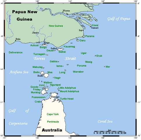
A map of the Torres Strait Islands. I have endeavoured to use native names wherever I could find them. If you can suggest ways in which this map could be made more up to date, don't hesitate to leave me a message to that effect. This map's source is here, with the uploader's modifications, and the GMT homepage says that the tools are released under the GNU General Public License. |
| วันที่ | 18 เมษายน พ.ศ. 2549 (original upload date) |
| แหล่งที่มา | นำเข้าจาก en.wikipedia มายังคอมมอนส์ |
| ผู้สร้างสรรค์ | Kelisi ที่ วิกิพีเดียภาษาอังกฤษ |
| เวอร์ชันอื่น | Image:TorresStraitIslandsMap (zh).png |
.png)
การอนุญาตใช้สิทธิ
Kelisi จากวิกิพีเดียภาษาอังกฤษ ในฐานะผู้ถือลิขสิทธิ์ของภาพหรือสื่อนี้ อนุญาตให้ใช้ภาพหรือสื่อนี้ภายใต้เงื่อนไขต่อไปนี้
| ไฟล์นี้อยู่ภายใต้สัญญาอนุญาต ครีเอทีฟคอมมอนส์ แบบแสดงที่มา-อนุญาตแบบเดียวกัน 3.0 ต้นฉบับ ทั้งนี้ เป็นไปตามข้อปฏิเสธความรับผิดชอบ | ||
| การแสดงที่มา: Kelisi จากวิกิพีเดียภาษาอังกฤษ | ||
| ||
| ป้ายแสดงสถานะลิขสิทธิ์นี้ถูกเพิ่มเพื่อให้เป็นไปตามการเปลี่ยนแปลงสัญญาอนุญาตของมูลนิธิวิกิมีเดีย จาก GFDL ไปยัง GFDL ควบคู่กับ CC-BY-SA 3.0 |

|
อนุญาตให้คัดลอก แจกจ่ายและ/หรือดัดแปรเอกสารนี้ภายใต้เงื่อนไขของสัญญาอนุญาตเอกสารเสรีของกนู รุ่น 1.2 หรือรุ่นใด ๆ นับจากนี้ที่ออกโดยมูลนิธิซอฟต์แวร์เสรี โดยไม่มีส่วนใดห้ามแก้ไข ไม่มีข้อความปกหน้าและปกหลัง สำเนาของสัญญาอนุญาตรวมอยู่ในส่วนชื่อ สัญญาอนุญาตเอกสารเสรีของกนู ทั้งนี้ เป็นไปตามข้อปฏิเสธความรับผิดชอบ |
บันทึกการอัพโหลด
The original description page was here. All following user names refer to en.wikipedia.
- 2006-04-19 00:55 Kelisi 929×922×8 (28510 bytes)
- 2006-04-18 03:38 Kelisi 929×922×8 (28133 bytes) A map of the Torres Strait Islands. I have endeavoured to use native names wherever I could find them. If you can suggest ways in which this map could be made more up to date, don't hesitate to leave me a message to that effect. This map's source is [htt
ประวัติไฟล์
คลิกวันที่/เวลาเพื่อดูไฟล์ที่ปรากฏในขณะนั้น
| วันที่/เวลา | รูปย่อ | ขนาด | ผู้ใช้ | ความเห็น | |
|---|---|---|---|---|---|
| ปัจจุบัน | 13:42, 13 มกราคม 2565 | | 929 × 922 (28 กิโลไบต์) | Kelisi | Reverted to version as of 00:09, 1 May 2007 (UTC) Hardly; those two colours are closer to each other. |
| 00:59, 7 ตุลาคม 2564 |  | 929 × 922 (31 กิโลไบต์) | Claude Zygiel | Better contrast | |
| 07:09, 1 พฤษภาคม 2550 |  | 929 × 922 (28 กิโลไบต์) | Stanmar | {{Information |Description=A map of the Torres Strait Islands. I have endeavoured to use native names wherever I could find them. If you can suggest ways in which this map could be made more up to date, don't hesitate to leave me a message to that effect. |
หน้าที่มีภาพนี้
หน้าต่อไปนี้ โยงมาที่ภาพนี้:
การใช้ไฟล์ข้ามโครงการ
วิกิอื่นต่อไปนี้ใช้ไฟล์นี้:
- การใช้บน af.wikipedia.org
- การใช้บน als.wikipedia.org
- การใช้บน ar.wikipedia.org
- การใช้บน azb.wikipedia.org
- การใช้บน ba.wikipedia.org
- การใช้บน bg.wikipedia.org
- การใช้บน bn.wikipedia.org
- การใช้บน br.wikipedia.org
- การใช้บน ca.wikipedia.org
- การใช้บน ceb.wikipedia.org
- การใช้บน cs.wikipedia.org
- การใช้บน cy.wikipedia.org
- การใช้บน da.wikipedia.org
- การใช้บน de.wikipedia.org
- Torres-Straße
- Prince-of-Wales-Insel (Queensland)
- Torres-Straits-Expedition
- Bellevue-Inseln
- Mabuiag
- Talbot-Inseln
- Boigu
- Flagge der Torres-Strait-Insulaner
- Manar-Inseln
- Thursday Island
- Horn Island (Torres Strait)
- Saibai
- Thursday-Inseln
- The Three Sisters (Torres Strait)
- Dauan
- Bet Island
- Poll Island
- Sue Island
- Murray-Inseln
- Murray Island
- Badu Island
- Moa Island
- Coconut Island (Australien)
- Yam Island
- Hammond Island
- Goods Island
- Friday Island (Torres Strait)
ดูการใช้ข้ามโครงการเพิ่มเติมของไฟล์นี้