
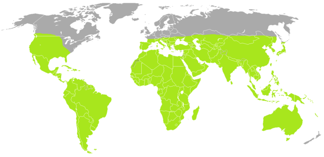
ไฟล์:Scorpiones distribution.png

ขนาดของตัวอย่างนี้: 800 × 388 พิกเซล ความละเอียดอื่น: 320 × 155 พิกเซล | 640 × 310 พิกเซล | 1,295 × 628 พิกเซล
ดูภาพที่มีความละเอียดสูงกว่า (1,295 × 628 พิกเซล, ขนาดไฟล์: 54 กิโลไบต์, ชนิดไมม์: image/png)
| รูปภาพหรือไฟล์เสียงนี้ ต้นฉบับอยู่ที่ คอมมอนส์ รายละเอียดด้านล่าง เป็นข้อความที่แสดงผลจาก ไฟล์ต้นฉบับในคอมมอนส์
|
| คำอธิบาย | A blank map of the world as of 2008, with country outlines, for making country locator maps. This map uses the Robinson projection centered on the Greenwich Prime Meridian and includes various microstates and island nations. All territories indicated in the UN listing of territories and regions are exhibited. |
| วันที่ | (UTC) |
| แหล่งที่มา | |
| ผู้สร้างสรรค์ |
|
| ภาพนี้ ได้รับการปรับแต่งภาพ ซึ่งหมายความว่าจะได้รับการเปลี่ยนแปลงภาพต่างจากต้นฉบับ การปรับปรุง: coloured. ต้นฉบับสามารถดูได้ที่นี่: BlankMap-World-Current.png. ปรับแต่งภาพโดย B kimmel.
|
| ข้าพเจ้า ผู้ถือลิขสิทธิ์ในงานนี้ ขอมอบงานให้เป็นสาธารณสมบัติ ประกาศนี้มีผลทั่วโลก ในบางประเทศ การกระทำดังกล่าวอาจไม่สามารถทำได้ตามกฎหมาย ข้าพเจ้าอนุญาตให้ทุกคนมีสิทธิ์ในการใช้ไฟล์นี้ในทุกเหตุผลการใช้ โดยไม่มีมีเงื่อนไข เว้นแต่กฎหมายไม่อนุญาตให้ทำเช่นนั้น |
บันทึกการอัพโหลด
This image is a derivative work of the following images:
- File:BlankMap-World.png licensed with PD-user
- 2010-06-11T08:50:57Z Doopy 1480x628 (58752 Bytes) {{Information |Description=A blank map of the world as of 2008, with country outlines, for making country locator maps. This map uses the [[:en:Robinson projection|Robinson projection]] centered on the Greenwich Prime Meridi
ประวัติไฟล์
คลิกวันที่/เวลาเพื่อดูไฟล์ที่ปรากฏในขณะนั้น
| วันที่/เวลา | รูปย่อ | ขนาด | ผู้ใช้ | ความเห็น | |
|---|---|---|---|---|---|
| ปัจจุบัน | 23:47, 3 กรกฎาคม 2553 | | 1,295 × 628 (54 กิโลไบต์) | B kimmel | orange = green |
| 17:20, 29 มิถุนายน 2553 |  | 1,295 × 628 (54 กิโลไบต์) | B kimmel | {{Information |Description=A blank map of the world as of 2008, with country outlines, for making country locator maps. This map uses the Robinson projection centered on the Greenwich Prime Meridian and includes various [[:en: |
หน้าที่มีภาพนี้
หน้าต่อไปนี้ โยงมาที่ภาพนี้:
การใช้ไฟล์ข้ามโครงการ
วิกิอื่นต่อไปนี้ใช้ไฟล์นี้:
- การใช้บน ast.wikipedia.org
- การใช้บน azb.wikipedia.org
- การใช้บน br.wikipedia.org
- การใช้บน en.wikipedia.org
- การใช้บน eo.wikipedia.org
- การใช้บน es.wikipedia.org
- การใช้บน eu.wikipedia.org
- การใช้บน fi.wikipedia.org
- การใช้บน fr.wikipedia.org
- การใช้บน he.wikipedia.org
- การใช้บน id.wikipedia.org
- การใช้บน kw.wikipedia.org
- การใช้บน mrj.wikipedia.org
- การใช้บน my.wikipedia.org
- การใช้บน nl.wikipedia.org
- การใช้บน ro.wikipedia.org
- การใช้บน ru.wikipedia.org
- การใช้บน sco.wikipedia.org
- การใช้บน simple.wikipedia.org
- การใช้บน sr.wikipedia.org
- การใช้บน tl.wikipedia.org
- การใช้บน tr.wikipedia.org