
ไฟล์:SFO map.png
ไม่มีภาพที่มีรายละเอียดสูงกว่านี้
SFO_map.png (405 × 583 พิกเซล, ขนาดไฟล์: 57 กิโลไบต์, ชนิดไมม์: image/png)
| รูปภาพหรือไฟล์เสียงนี้ ต้นฉบับอยู่ที่ คอมมอนส์ รายละเอียดด้านล่าง เป็นข้อความที่แสดงผลจาก ไฟล์ต้นฉบับในคอมมอนส์
|
ความย่อ
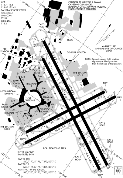
Detail from FAA diagram of San Francisco International Airport. Warning, this diagram contains material which is subject to change, do not use for navigation. There is also at least one error. The text block in the lower left gives lengths for runway "10L-18R." The runway designation should be "10L-28R."
การอนุญาตใช้สิทธิ
This image or file is a work of a Federal Aviation Administration employee, taken or made as part of that person's official duties. As a work of the U.S. federal government, the image is in the public domain in the United States.
|
 |
ประวัติไฟล์
คลิกวันที่/เวลาเพื่อดูไฟล์ที่ปรากฏในขณะนั้น
| วันที่/เวลา | รูปย่อ | ขนาด | ผู้ใช้ | ความเห็น | |
|---|---|---|---|---|---|
| ปัจจุบัน | 06:14, 17 ธันวาคม 2548 | | 405 × 583 (57 กิโลไบต์) | Sam916~commonswiki | ==Summary== Detail from FAA diagram of San Francisco International Airport. Warning, this diagram contains material which is subject to change, do not use for navigation. ==Licensing== {{PD-USGov-FAA}} |
หน้าที่มีภาพนี้
หน้าต่อไปนี้ โยงมาที่ภาพนี้:
การใช้ไฟล์ข้ามโครงการ
วิกิอื่นต่อไปนี้ใช้ไฟล์นี้:
- การใช้บน ca.wikipedia.org
- การใช้บน de.wikipedia.org
- การใช้บน fr.wikipedia.org
- การใช้บน he.wikipedia.org
- การใช้บน id.wikipedia.org
- การใช้บน ja.wikipedia.org
- การใช้บน mr.wikipedia.org
- การใช้บน ms.wikipedia.org
- การใช้บน ta.wikipedia.org
- การใช้บน vi.wikipedia.org