
ไฟล์:Peru - Moquegua Department (locator map).svg

ขนาดของตัวอย่าง PNG นี้ของไฟล์ SVG นี้: 492 × 600 พิกเซล ความละเอียดอื่น: 197 × 240 พิกเซล | 394 × 480 พิกเซล | 630 × 768 พิกเซล | 840 × 1,024 พิกเซล | 1,679 × 2,048 พิกเซล | 820 × 1,000 พิกเซล
ดูภาพที่มีความละเอียดสูงกว่า ((ไฟล์ SVG, 820 × 1,000 พิกเซล, ขนาดไฟล์: 1.03 เมกะไบต์))
| รูปภาพหรือไฟล์เสียงนี้ ต้นฉบับอยู่ที่ คอมมอนส์ รายละเอียดด้านล่าง เป็นข้อความที่แสดงผลจาก ไฟล์ต้นฉบับในคอมมอนส์
|
.svg)
| คำอธิบาย |
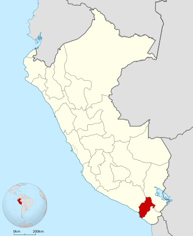
English: Locator map of Moquegua Department in Peru.
Español: Mapa de ubicación del Departamento de Moquegua en el Perú. |
| วันที่ | (UTC) |
| แหล่งที่มา | |
| ผู้สร้างสรรค์ |
|
.svg)
ข้าพเจ้า ในฐานะผู้ถือลิขสิทธิ์ของภาพหรือสื่อนี้ อนุญาตให้ใช้ภาพหรือสื่อนี้ภายใต้เงื่อนไขต่อไปนี้
ไฟล์นี้อยู่ภายใต้สัญญาอนุญาต ครีเอทีฟคอมมอนส์ แบบแสดงที่มา-อนุญาตแบบเดียวกัน 3.0 ต้นฉบับ
- คุณสามารถ:
- ที่จะแบ่งปัน – ที่จะทำสำเนา แจกจ่าย และส่งงานดังกล่าวต่อไป
- ที่จะเรียบเรียงใหม่ – ที่จะดัดแปลงงานดังกล่าว
- ภายใต้เงื่อนไขต่อไปนี้:
- แสดงที่มา – คุณต้องให้เกียรติเจ้าของงานอย่างเหมาะสม โดยเพิ่มลิงก์ไปยังสัญญาอนุญาต และระบุหากมีการเปลี่ยนแปลง คุณอาจทำเช่นนี้ได้ในรูปแบบใดก็ได้ตามควร แต่ต้องไม่ใช่ในลักษณะที่แนะว่าผู้ให้อนุญาตสนับสนุนคุณหรือการใช้งานของคุณ
- อนุญาตแบบเดียวกัน – หากคุณดัดแปลง เปลี่ยนรูป หรือต่อเติมงานนี้ คุณต้องใช้สัญญาอนุญาตแบบเดียวกันหรือแบบที่เหมือนกับสัญญาอนุญาตที่ใช้กับงานนี้เท่านั้น
บันทึกการอัพโหลด
This image is a derivative work of the following images:
- File:Peru_-_(Template).svg licensed with Cc-by-sa-3.0
- 2009-07-21T07:54:54Z Huhsunqu 820x1000 (1674312 Bytes) detail map
- 2009-07-15T06:39:44Z Huhsunqu 820x1000 (1396540 Bytes) ANCHOS
- 2009-07-06T05:07:34Z Huhsunqu 820x1000 (1398457 Bytes) {{Information |Description={{en|1=Blank political map of Perú}} {{es|1=Mapa plantilla de las regiones y departamentos del Perú.}} |Source=trabajo propio (own work) |Author=[[User:Huhsunqu|Huhsunqu]] |Date=2009-07-05 |Permis
Uploaded with derivativeFX
ประวัติไฟล์
คลิกวันที่/เวลาเพื่อดูไฟล์ที่ปรากฏในขณะนั้น
| วันที่/เวลา | รูปย่อ | ขนาด | ผู้ใช้ | ความเห็น | |
|---|---|---|---|---|---|
| ปัจจุบัน | 02:31, 2 พฤษภาคม 2561 | | 820 × 1,000 (1.03 เมกะไบต์) | Janitoalevic | Fixed. |
| 03:57, 5 กุมภาพันธ์ 2553 |  | 820 × 1,000 (1.45 เมกะไบต์) | Huhsunqu | {{Information |Description={{en|1=Locator map of en:Moquegua Department in Peru.}} {{es|1=Mapa de ubicación del es:Departamento de Moquegua en el Perú.}} |Source=*File:Peru_-_(Template).svg |Date=2010-02-04 20:45 (UTC) |Author=*[[:File |
.svg)
หน้าที่มีภาพนี้
หน้าต่อไปนี้ โยงมาที่ภาพนี้:
การใช้ไฟล์ข้ามโครงการ
วิกิอื่นต่อไปนี้ใช้ไฟล์นี้:
- การใช้บน an.wikipedia.org
- การใช้บน ar.wikipedia.org
- การใช้บน ast.wikipedia.org
- การใช้บน ay.wikipedia.org
- การใช้บน be.wikipedia.org
- การใช้บน bg.wikipedia.org
- การใช้บน ca.wikipedia.org
- การใช้บน da.wikipedia.org
- การใช้บน de.wikipedia.org
- การใช้บน en.wikipedia.org
- Department of Moquegua
- Ilo Province
- Regions of Peru
- Omate
- El Algarrobal District
- Ilo District
- Pacocha District
- Lloque District
- La Capilla District
- Ichuña District
- Coalaque District
- Chojata District
- Matalaque District
- Omate District
- Puquina District
- Quinistaquillas District
- Ubinas District
- Yunga District
- Carumas District
- Cuchumbaya District
- Moquegua District
- Samegua District
- San Cristóbal District, Mariscal Nieto
- Torata District
- Template:Moquegua-geo-stub
- El Algarrobal
- Lake Jucumarini
- Lake Vizcacha
- User:Ramatteo/Sandbox
- Jichu Qullu (Peru)
- Qillqata (Arequipa-Moquegua)
- Pachakutiq (Arequipa-Moquegua)
- Tacune
- Pirhuane (mountain)
- Pucasaya (Moquegua)
- Pacoorcco (Moquegua)
ดูการใช้ข้ามโครงการเพิ่มเติมของไฟล์นี้
.svg)
.svg)