
ไฟล์:Mecklenburg-Vorpommern districts 2011 colored labeled Meck-Pomm-border.svg

ขนาดของตัวอย่าง PNG นี้ของไฟล์ SVG นี้: 800 × 549 พิกเซล ความละเอียดอื่น: 320 × 220 พิกเซล | 640 × 439 พิกเซล | 1,024 × 703 พิกเซล | 1,280 × 879 พิกเซล | 2,560 × 1,757 พิกเซล | 1,129 × 775 พิกเซล
ดูภาพที่มีความละเอียดสูงกว่า ((ไฟล์ SVG, 1,129 × 775 พิกเซล, ขนาดไฟล์: 684 กิโลไบต์))
| รูปภาพหรือไฟล์เสียงนี้ ต้นฉบับอยู่ที่ คอมมอนส์ รายละเอียดด้านล่าง เป็นข้อความที่แสดงผลจาก ไฟล์ต้นฉบับในคอมมอนส์
|
ความย่อ
| คำอธิบาย |
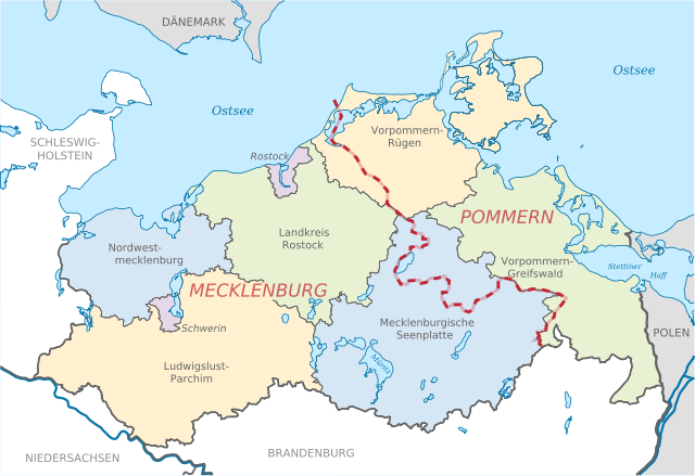
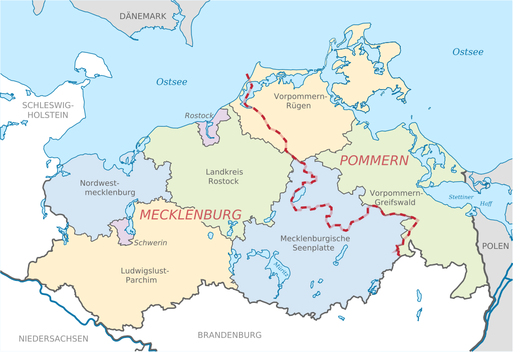
Deutsch: Karte mit Lage der Landkreise in Mecklenburg-Vorpommern, Deutschland nach der Kreisgebietsreform 2011. Eingezeichnet ist auch die Grenze zwischen den früheren Provinzen Pommern und Mecklenburg.
English: Locator map of counties in Mecklenburg-Vorpommern, Germany after county reorganization 2011. The red-white line indicates the former borders of the historical provinces Pommerania and Mecklenburg. |
| วันที่ | |
| แหล่งที่มา |
ไฟล์ภาพกราฟิกส์เวกเตอร์ไม่ได้ระบุการตรวจโดย W3C นี้ สร้างขึ้นโดยใช้ Adobe Illustrator งานของตัว, based on: |
| ผู้สร้างสรรค์ |
TUBS |
| เวอร์ชันอื่น |
|


การอนุญาตใช้สิทธิ
TUBS ในฐานะผู้ถือลิขสิทธิ์ของภาพหรือสื่อนี้ อนุญาตให้ใช้ภาพหรือสื่อนี้ภายใต้เงื่อนไขต่อไปนี้

|
อนุญาตให้คัดลอก แจกจ่ายและ/หรือดัดแปรเอกสารนี้ภายใต้เงื่อนไขของสัญญาอนุญาตเอกสารเสรีของกนู รุ่น 1.2 หรือรุ่นใด ๆ นับจากนี้ที่ออกโดยมูลนิธิซอฟต์แวร์เสรี โดยไม่มีส่วนใดห้ามแก้ไข ไม่มีข้อความปกหน้าและปกหลัง สำเนาของสัญญาอนุญาตรวมอยู่ในส่วนชื่อ สัญญาอนุญาตเอกสารเสรีของกนู |
ไฟล์นี้อยู่ภายใต้สัญญาอนุญาตครีเอทีฟคอมมอนส์ รุ่นแสดงที่มา 3.0 ต้นฉบับ, 2.5 ทั่วไป, 2.0 ทั่วไป และ 1.0 ทั่วไป
การแสดงที่มา: TUBS
- คุณสามารถ:
- ที่จะแบ่งปัน – ที่จะทำสำเนา แจกจ่าย และส่งงานดังกล่าวต่อไป
- ที่จะเรียบเรียงใหม่ – ที่จะดัดแปลงงานดังกล่าว
- ภายใต้เงื่อนไขต่อไปนี้:
- แสดงที่มา – คุณต้องให้เกียรติเจ้าของงานอย่างเหมาะสม โดยเพิ่มลิงก์ไปยังสัญญาอนุญาต และระบุหากมีการเปลี่ยนแปลง คุณอาจทำเช่นนี้ได้ในรูปแบบใดก็ได้ตามควร แต่ต้องไม่ใช่ในลักษณะที่แนะว่าผู้ให้อนุญาตสนับสนุนคุณหรือการใช้งานของคุณ
ไฟล์นี้อยู่ภายใต้สัญญาอนุญาตครีเอทีฟคอมมอนส์ รุ่นแสดงที่มา-อนุญาตแบบเดียวกัน 3.0 ต้นฉบับ, 2.5 ทั่วไป, 2.0 ทั่วไป และ 1.0 ทั่วไป
การแสดงที่มา: TUBS
- คุณสามารถ:
- ที่จะแบ่งปัน – ที่จะทำสำเนา แจกจ่าย และส่งงานดังกล่าวต่อไป
- ที่จะเรียบเรียงใหม่ – ที่จะดัดแปลงงานดังกล่าว
- ภายใต้เงื่อนไขต่อไปนี้:
- แสดงที่มา – คุณต้องให้เกียรติเจ้าของงานอย่างเหมาะสม โดยเพิ่มลิงก์ไปยังสัญญาอนุญาต และระบุหากมีการเปลี่ยนแปลง คุณอาจทำเช่นนี้ได้ในรูปแบบใดก็ได้ตามควร แต่ต้องไม่ใช่ในลักษณะที่แนะว่าผู้ให้อนุญาตสนับสนุนคุณหรือการใช้งานของคุณ
- อนุญาตแบบเดียวกัน – หากคุณดัดแปลง เปลี่ยนรูป หรือต่อเติมงานนี้ คุณต้องใช้สัญญาอนุญาตแบบเดียวกันหรือแบบที่เหมือนกับสัญญาอนุญาตที่ใช้กับงานนี้เท่านั้น
คุณสามารถเลือกสัญญาอนุญาตดังกล่าวตามต้องการ
TUBS ในฐานะผู้ถือลิขสิทธิ์ของภาพหรือสื่อนี้ อนุญาตให้ใช้ภาพหรือสื่อนี้ภายใต้เงื่อนไขต่อไปนี้
| ไฟล์นี้มีให้ใช้ภายใต้ CC0 1.0 Universal Public Domain Dedication ของครีเอทีฟคอมมอนส์ | |
| The person who associated a work with this deed has dedicated the work to the public domain by waiving all of their rights to the work worldwide under copyright law, including all related and neighboring rights, to the extent allowed by law. You can copy, modify, distribute and perform the work, even for commercial purposes, all without asking permission.
|
| ข้าพเจ้า ผู้ถือลิขสิทธิ์ในงานนี้ ขอมอบงานให้เป็นสาธารณสมบัติ ประกาศนี้มีผลทั่วโลก ในบางประเทศ การกระทำดังกล่าวอาจไม่สามารถทำได้ตามกฎหมาย ข้าพเจ้าอนุญาตให้ทุกคนมีสิทธิ์ในการใช้ไฟล์นี้ในทุกเหตุผลการใช้ โดยไม่มีมีเงื่อนไข เว้นแต่กฎหมายไม่อนุญาตให้ทำเช่นนั้น |
| กอปปีเลฟต์: งานศิลปะนี้ไม่มีมูลค่า คุณสามารถแจกจ่ายและ/หรือแก้ไขได้ภายใต้เงื่อนไข Free Art License คุณสามารถพบตัวอย่างของสัญญาอนุญาตนี้ได้บนไซต์ Copyleft Attitude รวมทั้งบนไซต์อื่น ๆ ด้วย |

|
TUBS ซึ่งเป็นผู้ถือลิขสิทธิ์ของไฟล์นี้ อนุญาตให้นำไฟล์นี้ไปใช้ได้ในทุกวัตถุประสงค์ รวมไปถึงการทำซ้ำ การนำไฟล์นี้ไปใช้ในการสร้างไฟล์ใหม่ การใช้เพื่อการค้า และการใช้อื่น ๆ โดยมีเงื่อนไขว่า ต้องระบุชื่อผู้ถือลิขสิทธิ์ของไฟล์นี้อย่างเหมาะสมเมื่อนำไฟล์นี้ไปใช้ |
|
|
คุณสามารถเลือกสัญญาอนุญาตดังกล่าวตามต้องการ

|
I'd greatly appreciate, that you attribute this media file to Wikimedia Commons, if used outside Wikipedia or Commons. For use in publications such as books, newspapers, blogs, websites, please insert here the following line:
|
ประวัติไฟล์
คลิกวันที่/เวลาเพื่อดูไฟล์ที่ปรากฏในขณะนั้น
| วันที่/เวลา | รูปย่อ | ขนาด | ผู้ใช้ | ความเห็น | |
|---|---|---|---|---|---|
| ปัจจุบัน | 18:51, 6 กันยายน 2554 | | 1,129 × 775 (684 กิโลไบต์) | TUBS | =={{int:filedesc}}== {{Information |Description= {{de|Lage der Landkreise in Mecklenburg-Vorpommern, Deutschland nach der Kreisgebietsreform 2011. Eingezeichnet ist auch die Grenze zwischen den früheren |
หน้าที่มีภาพนี้
ไม่มีหน้าใดโยงมาที่ภาพนี้
การใช้ไฟล์ข้ามโครงการ
วิกิอื่นต่อไปนี้ใช้ไฟล์นี้:
- การใช้บน de.wikipedia.org
- การใช้บน kk.wikipedia.org
- การใช้บน sv.wikipedia.org
- การใช้บน sw.wikipedia.org
- การใช้บน tr.wikipedia.org
- การใช้บน uk.wikipedia.org
- การใช้บน vec.wikipedia.org
- การใช้บน vi.wikipedia.org
- การใช้บน vo.wikipedia.org
- การใช้บน war.wikipedia.org
- การใช้บน yo.wikipedia.org
- การใช้บน zh-min-nan.wikipedia.org
- การใช้บน zh-yue.wikipedia.org
- การใช้บน zh.wikipedia.org