
ไฟล์:Map-Lusophone World-en.png

ขนาดของตัวอย่างนี้: 800 × 370 พิกเซล ความละเอียดอื่น: 320 × 148 พิกเซล | 640 × 296 พิกเซล | 1,357 × 628 พิกเซล
ดูภาพที่มีความละเอียดสูงกว่า (1,357 × 628 พิกเซล, ขนาดไฟล์: 37 กิโลไบต์, ชนิดไมม์: image/png)
| รูปภาพหรือไฟล์เสียงนี้ ต้นฉบับอยู่ที่ คอมมอนส์ รายละเอียดด้านล่าง เป็นข้อความที่แสดงผลจาก ไฟล์ต้นฉบับในคอมมอนส์
|
ความย่อ
| คำอธิบาย |
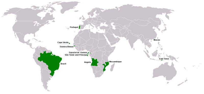
Map of Lusophone world. Map made from Image:BlankMap-World.png. The blank map was made by User:Vardion and adapted by User:E Pluribus Anthony for Wikipedia. |
||||
| วันที่ | |||||
| แหล่งที่มา | งานของตัว | ||||
| ผู้สร้างสรรค์ | This version was made by User:Yug with country names by User:Sting. Fixed by User:The Ogre | ||||
| การอนุญาต (การใช้ไฟล์นี้ใหม่) |
|
||||
| เวอร์ชันอื่น |
|


ประวัติไฟล์
คลิกวันที่/เวลาเพื่อดูไฟล์ที่ปรากฏในขณะนั้น
| วันที่/เวลา | รูปย่อ | ขนาด | ผู้ใช้ | ความเห็น | |
|---|---|---|---|---|---|
| ปัจจุบัน | 04:35, 8 มีนาคม 2561 | | 1,357 × 628 (37 กิโลไบต์) | Maphobbyist | South Sudan border |
| 22:13, 21 เมษายน 2559 |  | 1,357 × 628 (14 กิโลไบต์) | Avayak | optimized losslessly | |
| 06:09, 23 กุมภาพันธ์ 2551 |  | 1,357 × 628 (47 กิโลไบต์) | The Ogre | New version, taken from the English wikipedia, where en:User:Domaleixo had done a new version of this map adding Equatorial Guinea, that also has Portuguese as official language. The license is "I, the copyright holder of this work, hereby release it | |
| 10:20, 4 มิถุนายน 2550 |  | 1,357 × 628 (47 กิโลไบต์) | Hoshie | added Cabinda (Angola) and Montenegro. Same license. Put Cabinda in green as it is a part of Angola. | |
| 23:06, 4 พฤษภาคม 2550 |  | 1,357 × 628 (19 กิโลไบต์) | Tene~commonswiki | Optimised (0) | |
| 21:00, 4 พฤษภาคม 2550 |  | 1,357 × 628 (47 กิโลไบต์) | EugeneZelenko | Corrected version from Image:Map-Lusophone World-eng.png by User:The Ogre. Same license. | |
| 01:50, 24 มกราคม 2549 |  | 1,357 × 628 (38 กิโลไบต์) | Sting | Map of Lusophone world. Map made from Image:BlankMap-World.png The blank map was made by User:Vardion and adapted by User:E Pluribus Anthony for Wikipedia. This version was made by User:Yug with country names by [[Us |
หน้าที่มีภาพนี้
ไม่มีหน้าใดโยงมาที่ภาพนี้
การใช้ไฟล์ข้ามโครงการ
วิกิอื่นต่อไปนี้ใช้ไฟล์นี้:
- การใช้บน da.wikipedia.org
- การใช้บน de.wikipedia.org
- การใช้บน en.wikipedia.org
- การใช้บน fr.wikipedia.org
- การใช้บน nl.wikipedia.org
- การใช้บน nn.wikipedia.org
- การใช้บน no.wikipedia.org
- การใช้บน pt.wikinews.org
- การใช้บน sv.wikipedia.org
- การใช้บน zh.wikipedia.org