
ไฟล์:Island of Ireland location map Londonderry.svg

ขนาดของตัวอย่าง PNG นี้ของไฟล์ SVG นี้: 796 × 599 พิกเซล ความละเอียดอื่น: 319 × 240 พิกเซล | 638 × 480 พิกเซล | 1,020 × 768 พิกเซล | 1,280 × 964 พิกเซล | 2,560 × 1,928 พิกเซล | 931 × 701 พิกเซล
ดูภาพที่มีความละเอียดสูงกว่า ((ไฟล์ SVG, 931 × 701 พิกเซล, ขนาดไฟล์: 826 กิโลไบต์))
| รูปภาพหรือไฟล์เสียงนี้ ต้นฉบับอยู่ที่ คอมมอนส์ รายละเอียดด้านล่าง เป็นข้อความที่แสดงผลจาก ไฟล์ต้นฉบับในคอมมอนส์
|
| คำอธิบาย |
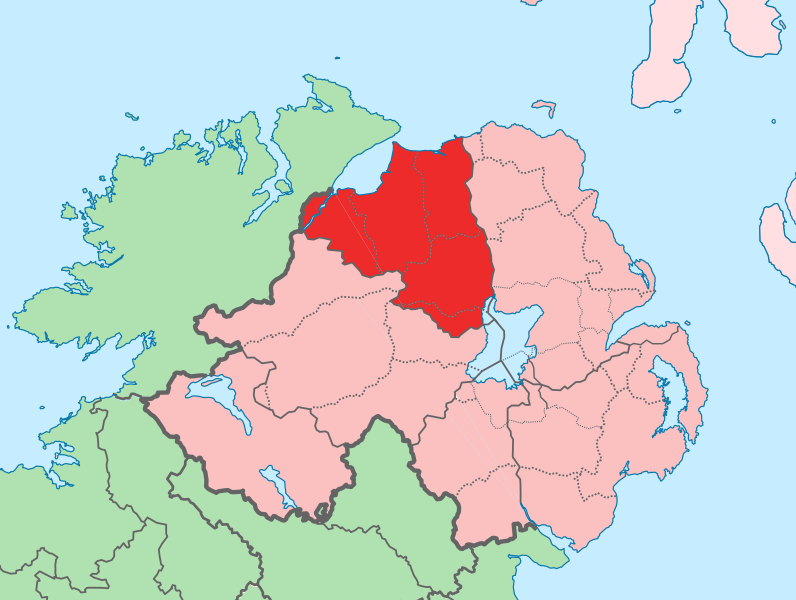
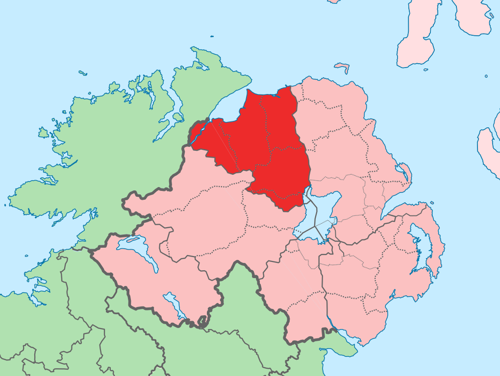
English: The island of Ireland, showing international border between Ireland and Northern Ireland, traditional provinces, traditional counties, and local authority areas in Ireland and Northern Ireland. |
| วันที่ | (UTC) |
| แหล่งที่มา | |
| ผู้สร้างสรรค์ |
|
| ภาพนี้ ได้รับการปรับแต่งภาพ ซึ่งหมายความว่าจะได้รับการเปลี่ยนแปลงภาพต่างจากต้นฉบับ การปรับปรุง: Added colours to distinguish county in focus. ต้นฉบับสามารถดูได้ที่นี่: Island of Ireland location map.svg. ปรับแต่งภาพโดย Mabuska.
|
ข้าพเจ้า ในฐานะผู้ถือลิขสิทธิ์ของภาพหรือสื่อนี้ อนุญาตให้ใช้ภาพหรือสื่อนี้ภายใต้เงื่อนไขต่อไปนี้
ไฟล์นี้อยู่ภายใต้สัญญาอนุญาต ครีเอทีฟคอมมอนส์ แบบแสดงที่มา-อนุญาตแบบเดียวกัน 3.0 ต้นฉบับ
- คุณสามารถ:
- ที่จะแบ่งปัน – ที่จะทำสำเนา แจกจ่าย และส่งงานดังกล่าวต่อไป
- ที่จะเรียบเรียงใหม่ – ที่จะดัดแปลงงานดังกล่าว
- ภายใต้เงื่อนไขต่อไปนี้:
- แสดงที่มา – คุณต้องให้เกียรติเจ้าของงานอย่างเหมาะสม โดยเพิ่มลิงก์ไปยังสัญญาอนุญาต และระบุหากมีการเปลี่ยนแปลง คุณอาจทำเช่นนี้ได้ในรูปแบบใดก็ได้ตามควร แต่ต้องไม่ใช่ในลักษณะที่แนะว่าผู้ให้อนุญาตสนับสนุนคุณหรือการใช้งานของคุณ
- อนุญาตแบบเดียวกัน – หากคุณดัดแปลง เปลี่ยนรูป หรือต่อเติมงานนี้ คุณต้องใช้สัญญาอนุญาตแบบเดียวกันหรือแบบที่เหมือนกับสัญญาอนุญาตที่ใช้กับงานนี้เท่านั้น
บันทึกการอัพโหลด
This image is a derivative work of the following images:
- File:Island_of_Ireland_location_map.svg licensed with Cc-by-sa-3.0
- 2010-03-06T20:43:33Z Rannpháirtí anaithnid 1450x1807 (679207 Bytes) Fix incorrectly coloured isands.
- 2010-03-03T22:19:29Z Rannpháirtí anaithnid 1450x1807 (679744 Bytes) {{Information |Description={{de|Positionskarte von [[:de:Irland|Irland]]}} Quadratische Plattkarte, N-S-Streckung 170 %. Geographische Begrenzung der Karte: * N: 55.6° N * S: 51.2° N * W: 11.0° W * O: 5.0° W {{en|Location
Uploaded with derivativeFX
ประวัติไฟล์
คลิกวันที่/เวลาเพื่อดูไฟล์ที่ปรากฏในขณะนั้น
| วันที่/เวลา | รูปย่อ | ขนาด | ผู้ใช้ | ความเห็น | |
|---|---|---|---|---|---|
| ปัจจุบัน | 20:14, 19 กรกฎาคม 2553 | | 931 × 701 (826 กิโลไบต์) | Mabuska | another attempt |
| 20:07, 19 กรกฎาคม 2553 |  | 931 × 701 (826 กิโลไบต์) | Mabuska | attempt to fix boundary issues | |
| 18:36, 19 กรกฎาคม 2553 |  | 934 × 717 (828 กิโลไบต์) | Mabuska | {{Information |Description={{en|The island of Ireland, showing international border between Northern Ireland and Republic of Ireland, traditional provinces, traditional counties, and local authority areas in the Republic of Ireland and Northern Ireland.}} |
หน้าที่มีภาพนี้
หน้าต่อไปนี้ โยงมาที่ภาพนี้:
การใช้ไฟล์ข้ามโครงการ
วิกิอื่นต่อไปนี้ใช้ไฟล์นี้:
- การใช้บน an.wikipedia.org
- การใช้บน bg.wikipedia.org
- การใช้บน cs.wikipedia.org
- การใช้บน de.wikipedia.org
- การใช้บน en.wikipedia.org
- Derry
- County Londonderry
- Limavady
- Dungiven
- Sperrins
- Coleraine
- Portstewart
- Moneymore
- Draperstown
- List of Ireland-related topics
- Maghera
- Corick
- Magilligan
- Lough Foyle
- List of places in Northern Ireland
- Magherafelt
- Bogside
- Free Derry Corner
- List of places in County Londonderry
- Ballynahone Bog
- Binevenagh
- Castledawson
- Glenshane Pass
- Drumsurn
- Ballykelly, County Londonderry
- Swatragh
- Castlerock
- Newbuildings
- Ballynagalliagh
- Shantallow
- Eglinton, County Londonderry
- Claudy
- Articlave
- Bellaghy
- Clady, County Londonderry
- Culmore
- Burnfoot, County Londonderry
- Downhill, County Londonderry
- Feeny
- Garvagh
- Greysteel
- Kilrea
- Lettershandoney
- Macosquin
- Strathfoyle
- Tobermore
ดูการใช้ข้ามโครงการเพิ่มเติมของไฟล์นี้