ไฟล์:Hindu Kush satellite image.jpg
ไม่รองรับเนื้อหาของหน้าในภาษาอื่น
จากวิกิพีเดีย สารานุกรมเสรี

ดูภาพที่มีความละเอียดสูงกว่า(5,600 × 4,400 พิกเซล, ขนาดไฟล์: 5.01 เมกะไบต์, ชนิดไมม์: image/jpeg)

Wikimedia Commons logo รูปภาพหรือไฟล์เสียงนี้ ต้นฉบับอยู่ที่ คอมมอนส์ รายละเอียดด้านล่าง เป็นข้อความที่แสดงผลจาก ไฟล์ต้นฉบับในคอมมอนส์
คอมมอนส์เป็นเว็บไซต์ในโครงการสำหรับเก็บรวบรวมสื่อเสรี ที่ คุณสามารถช่วยได้

ความย่อ

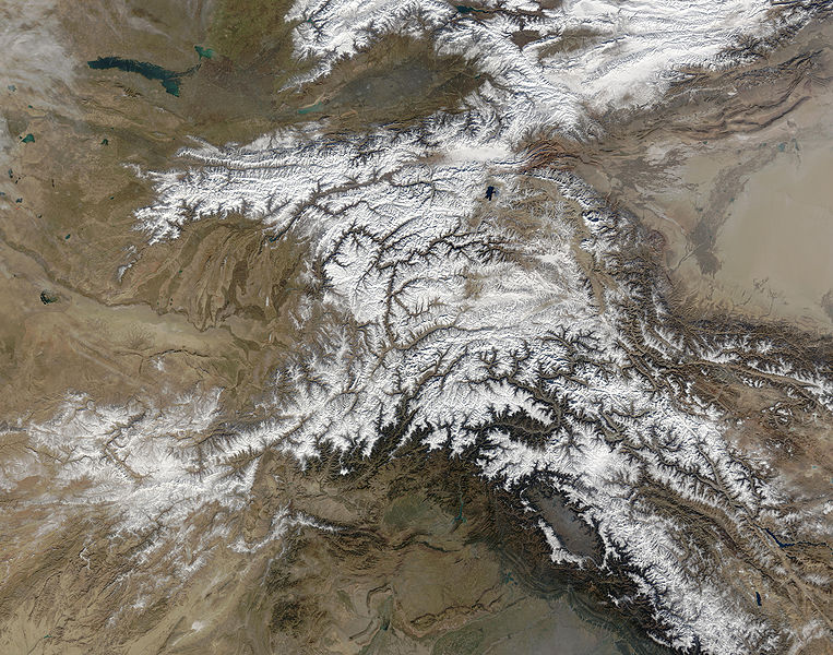
คำอธิบาย The Hindu Kush occupies the lower-left-center of this true-color MODIS satellite image, acquired 28 November 2003.
วันที่
แหล่งที่มา NASA's Earth Observatory
ผู้สร้างสรรค์ Jeff Schmaltz, MODIS Land Rapid Response Team at NASA GSFC
การอนุญาต
(การใช้ไฟล์นี้ใหม่)
Public domain - original work of NASA
เวอร์ชันอื่น

ไฟล์อื่นที่ใช้ไฟล์นี้:  High Asia Mountain Ranges.jpg

Earth Observatory text: [1]

Once used by Alexander the Great in his effort to conquer the known world, the high-altitude passes of the Hindu Kush remain important trade and travel routes. Glaciers and heavy snowfall are ever-present features of these mountains, which rise to 7,692 meters (26,236 feet) in height.

Straddling the borders between Pakistan, Afghanistan, and India, the Hindu Kush is heavily populated. Though the valleys are heavily irrigated, growing crops at such high altitudes and low temperatures is difficult. The residents also have to worry about earthquakes, which are common as the Eurasian and Indo-Australian tectonic plates continue to push against one-another. This constant pressure and grinding create an average of four major (measuring at least 5 on the Richter scale) earthquakes a year.

In this true-color Terra Moderate Resolution Imaging Spectroradiometer (MODIS) image, the Hindu Kush occupies the lower-left-center of the image. To the left are the relatively lower altitude plains of southern Kazakhstan, Uzbekistan, Turkmenistan, Afghanistan, and Pakistan. The fertile plains surrounding the northern strands of the Indus River are a deep green at the bottom center of the image (a translucent veil of smog adds a gray tinge to the region). Straddling the mountains north of the Kush are Kyrgyzstan and Tajikistan, which butt up against the arid Tarim basin of northwestern China. The Silk Road, the all-important trade route between China and Europe, runs through the Hindu Kush and this basin. This true-color Terra MODIS image was acquired on November 28, 2003.

Image courtesy Jeff Schmaltz, MODIS Land Rapid Response Team at NASA GSFC

การอนุญาตใช้สิทธิ

Public domain ภาพนี้เป็นสาธารณสมบัติ เนื่องจากเป็นภาพที่สร้างขึ้นโดยองค์การบริหารการบินและอวกาศแห่งชาติ (NASA) ซึ่งตามนโยบายด้านลิขสิทธิ์ของนาซาระบุไว้ว่า "ภาพและสื่อต่าง ๆ ของนาซาไม่ได้รับการคุ้มครองโดยลิขสิทธิ์ยกเว้นจะระบุไว้ว่ามีลิขสิทธิ์" ดูเพิ่มที่ หน้านโยบายด้านลิขสิทธิ์ของนาซา หรือ นโยบายการใช้ภาพของ JPL
คำเตือน:

คำบรรยายโดยย่อ

เพิ่มคำบรรยายทรรทัดเดียวเพื่อขยายความว่าไฟล์นี้มีอะไร

ไอเทมที่แสดงอยู่ในไฟล์นี้

ประกอบด้วย

ประวัติไฟล์

คลิกวันที่/เวลาเพื่อดูไฟล์ที่ปรากฏในขณะนั้น

วันที่/เวลารูปย่อขนาดผู้ใช้ความเห็น
ปัจจุบัน11:39, 6 มิถุนายน 2549รูปย่อสำหรับรุ่นเมื่อ 11:39, 6 มิถุนายน 25495,600 × 4,400 (5.01 เมกะไบต์)Avenue{{Information |Description=The Hindu Kush occupies the lower-left-center of this true-color MODIS satellite image, acquired 28 November 2003. |Source=[NASA's Earth Observatory http://earthobservatory.nasa.gov/Newsroom/NewImages/images.php3?img_id=16411] |

หน้าต่อไปนี้ โยงมาที่ภาพนี้:

การใช้ไฟล์ข้ามโครงการ

วิกิอื่นต่อไปนี้ใช้ไฟล์นี้:

ข้อมูลเกี่ยวกับภาพ