
ไฟล์:Dolina-Pano-3.jpg
ดูภาพที่มีความละเอียดสูงกว่า (1,500 × 2,607 พิกเซล, ขนาดไฟล์: 6.83 เมกะไบต์, ชนิดไมม์: image/jpeg)
| รูปภาพหรือไฟล์เสียงนี้ ต้นฉบับอยู่ที่ คอมมอนส์ รายละเอียดด้านล่าง เป็นข้อความที่แสดงผลจาก ไฟล์ต้นฉบับในคอมมอนส์
|
ความย่อ
| คำอธิบาย |
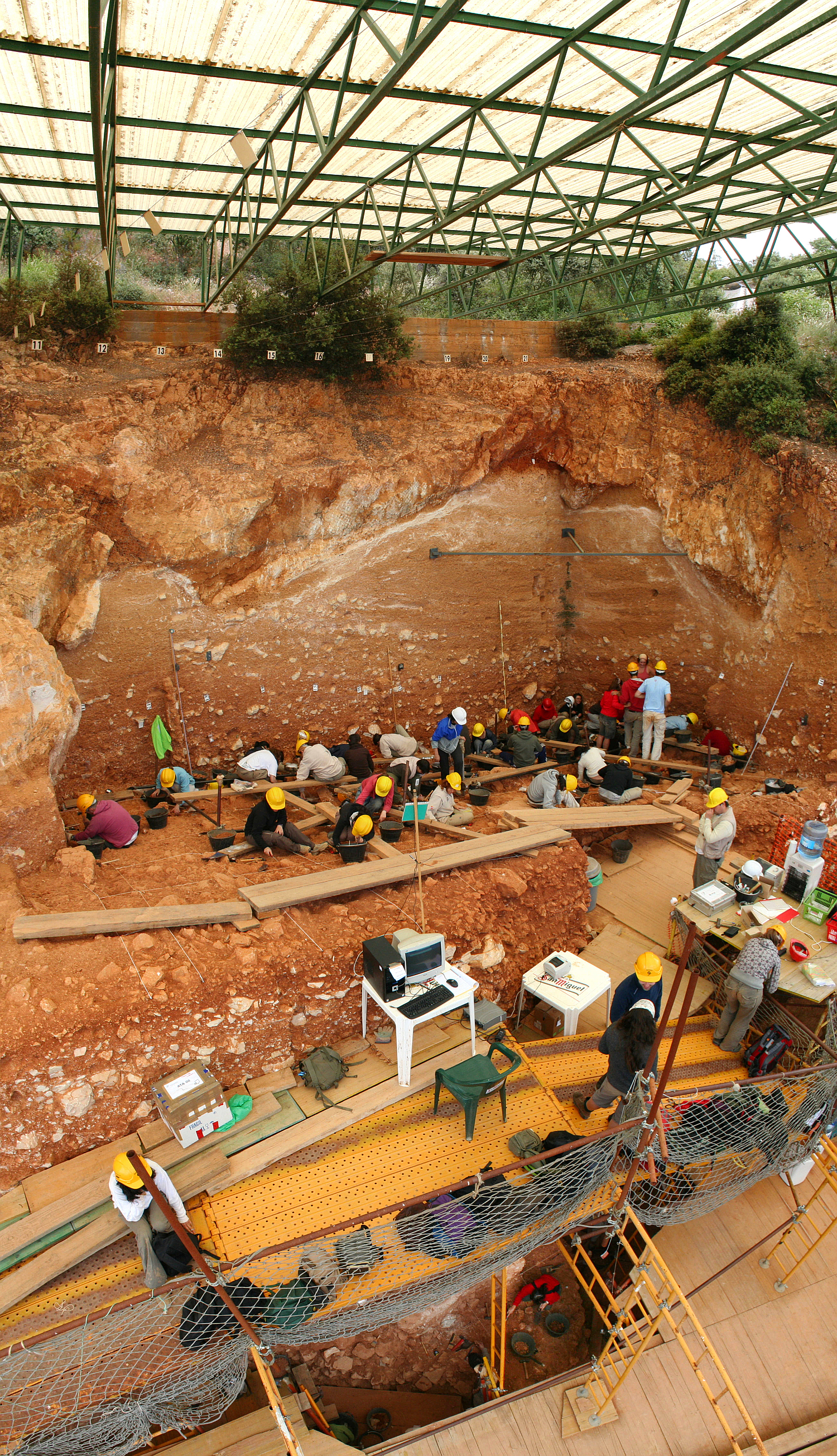
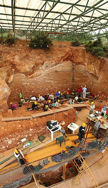
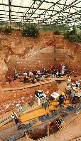
English: Excavations at the site of Gran Dolina, in Atapuerca (Spain), during 2008. Panoramic photography formed using 3 individual photographies with Hugin software. TD-10 archaeological level is being excavated where the most of the people are. It is a Homo heidelbergensis camp. Under the plank, we can observe a woman with red sweatshirt excavating TD-6 archaeological level, where were found the first remains of Homo antecessor.
Español: Excavaciones en el yacimiento de Gran Dolina, en Atapuerca (España), durante el año 2008. Fotografía panorámica formada a partir de 3 fotografías individuales usando Hugin. La excavación en la parte superior se corresponde con el nivel arqueológico TD-10, el cuál es un campamento de Homo heidelbergensis. La parte inferior, debajo de los tablones, se observa a una excavadora con sudadera roja que excava el nivel TD-6, donde aparecieron los restos del Homo antecessor.
Français : Fouilles menées en 2008 sur le site de Gran Dolina dans la Sierra d'Atapuerca, située dans la commune d'Atapuerca dans la province de Burgos en Castille-et-León (Espagne). Image panoramique obtenue en assemblant trois clichés avec le logiciel Hugin. Le niveau archéologique TD10, où se trouvent la plupart des personnes, est un camp d'Homo heidelbergensis. Sous les planches, on distingue une personne travaillant sur le niveau TD6, où ont été trouvés les premiers restes d'Homo antecessor.
Русский: Археологические раскопки в Атапуэрка, близ Гран-Долины (Испания), в 2008 году. |
| วันที่ | |
| แหล่งที่มา | งานของตัว |
| ผู้สร้างสรรค์ | Mario Modesto Mata |
| เวอร์ชันอื่น |
|
.jpg)


| ตำแหน่งที่ตั้งกล้อง | | ภาพนี้และภาพอื่น ๆ ณ สถานที่เดียวกันที่ OpenStreetMap |
|---|
Assessment
|
ภาพนี้ได้รับการคัดสรรให้เป็น ภาพประจำวัน สำหรับวันที่ 18 พฤศจิกายน พ.ศ. 2551 ภาพดังกล่าวมีคำอธิบายดังต่อไปนี้: English: Excavations at the site of Gran Dolina, in Atapuerca (Spain), during 2008. ภาษาอื่น ๆ:
Čeština: Archeologické naleziště „Gran Dolina“ ve španělské oblasti Atapuerca. Byly zde nalezeny pozůstatky tábořišť Homo heidelbergensis a Homo antecessor. Dansk: Udgravningerne i Gran Dolina i Spanien, 2008, af en lejrplads for Homo heidelbergensis. Deutsch: Archäologische Ausgrabungsstätte „Gran Dolina“ im spanischen Atapuerca. Hier wird ein Lager einer Gruppe von Homo heidelbergensis ausgehoben. English: Excavations at the site of Gran Dolina, in Atapuerca (Spain), during 2008. Español: Excavaciones en el yacimiento de Gran Dolina, en Atapuerca (España), durante el año 2008. Fotografía panorámica formada a partir de 3 fotografías individuales usando Hugin. La excavación en la parte superior se corresponde con el nivel arqueológico TD-10, el cuál es un campamento de Homo heidelbergensis. La parte inferior, debajo de los tablones, se observa a una excavadora con sudadera roja que excava el nivel TD-6, donde aparecieron los restos del Homo antecessor. Français : Fouilles archéologiques sur le site de la Gran Dolina à Atapuerca (Espagne). Un groupe d'une trentaine de squelettes d'Homo heidelbergensis remontant à 400 000 ans y a été découvert dans les années 1980. Italiano: Scavi nel sito archeologico di Gran Dolina ad Atapuerca, Spagna. Magyar: Régészeti ásatás az atapuercai Gran Dolina nevű lelőhelyen (Kasztília és León, Spanyolország) Nederlands: de archeologische opgraving "Gran Dolina" in het Spaanse karstgebied Atapuerca, waar een laag met een groep van Homo heidelbergensissen wordt uitgegraven. 中文: 西班牙阿塔普埃尔卡格兰多利纳遗址挖掘 中文(繁體): 西班牙阿塔普埃爾卡格蘭多利納遺址挖掘 |
การอนุญาตใช้สิทธิ
- คุณสามารถ:
- ที่จะแบ่งปัน – ที่จะทำสำเนา แจกจ่าย และส่งงานดังกล่าวต่อไป
- ที่จะเรียบเรียงใหม่ – ที่จะดัดแปลงงานดังกล่าว
- ภายใต้เงื่อนไขต่อไปนี้:
- แสดงที่มา – คุณต้องให้เกียรติเจ้าของงานอย่างเหมาะสม โดยเพิ่มลิงก์ไปยังสัญญาอนุญาต และระบุหากมีการเปลี่ยนแปลง คุณอาจทำเช่นนี้ได้ในรูปแบบใดก็ได้ตามควร แต่ต้องไม่ใช่ในลักษณะที่แนะว่าผู้ให้อนุญาตสนับสนุนคุณหรือการใช้งานของคุณ
- อนุญาตแบบเดียวกัน – หากคุณดัดแปลง เปลี่ยนรูป หรือต่อเติมงานนี้ คุณต้องใช้สัญญาอนุญาตแบบเดียวกันหรือแบบที่เหมือนกับสัญญาอนุญาตที่ใช้กับงานนี้เท่านั้น

|
อนุญาตให้คัดลอก แจกจ่ายและ/หรือดัดแปรเอกสารนี้ภายใต้เงื่อนไขของสัญญาอนุญาตเอกสารเสรีของกนู รุ่น 1.2 หรือรุ่นใด ๆ นับจากนี้ที่ออกโดยมูลนิธิซอฟต์แวร์เสรี โดยไม่มีส่วนใดห้ามแก้ไข ไม่มีข้อความปกหน้าและปกหลัง สำเนาของสัญญาอนุญาตรวมอยู่ในส่วนชื่อ สัญญาอนุญาตเอกสารเสรีของกนู |
In using this image or any subsequent derivatives of it, you are required to release the image under the same license. As such, any reproduction of this image, in any medium, must appear with a copy of, or full URL of the license.
Attribution of this image to the author (Mario Modesto Mata) is required in a prominent location near to the image.
No other conditions may be added to, or removed from this license without the permission of the author and copyright holder.Please review the full license requirements carefully before using this image. If you would like to clarify the terms of the license or negotiate less restrictive commercial licensing outside of the bounds of GFDL/CC-BY-SA, please contact me by email, or if you don't have a Wikipedia account you can leave a message on my talk page with your contact details and your request.
Click on the image to see my portfolio

ประวัติไฟล์
คลิกวันที่/เวลาเพื่อดูไฟล์ที่ปรากฏในขณะนั้น
| วันที่/เวลา | รูปย่อ | ขนาด | ผู้ใช้ | ความเห็น | |
|---|---|---|---|---|---|
| ปัจจุบัน | 20:48, 7 กันยายน 2551 | | 1,500 × 2,607 (6.83 เมกะไบต์) | Mario modesto | {{Information |Description={{en|1=Excavations at the site of Gran Dolina, in Atapuerca (Spain), during 2008. Panoramic photography formed using 3 individual photographies with Hugin software. TD-10 archaeological level is being excavated where the most of |
หน้าที่มีภาพนี้
ไม่มีหน้าใดโยงมาที่ภาพนี้
การใช้ไฟล์ข้ามโครงการ
วิกิอื่นต่อไปนี้ใช้ไฟล์นี้:
- การใช้บน ar.wikipedia.org
- การใช้บน ast.wikipedia.org
- การใช้บน az.wikipedia.org
- การใช้บน be.wikipedia.org
- การใช้บน bn.wikipedia.org
- การใช้บน bs.wikipedia.org
- การใช้บน ca.wikipedia.org
- การใช้บน ceb.wikipedia.org
- การใช้บน crh.wikipedia.org
- การใช้บน cs.wikipedia.org
- การใช้บน cv.wikipedia.org
- การใช้บน da.wikipedia.org
- การใช้บน de.wikipedia.org
- การใช้บน de.wikivoyage.org
- การใช้บน el.wikipedia.org
- การใช้บน en.wikipedia.org
- Archaeological excavation
- Portal:Science
- List of World Heritage Sites in Spain
- Wikipedia:Featured pictures/Sciences/Others
- Wikipedia:Featured pictures thumbs/13
- Portal:Paleontology/Selected picture
- Portal:Paleontology/Selected picture/32
- User:Papa Lima Whiskey
- Wikipedia:Wikipedia Signpost/2008-09-29/Features and admins
- Archaeology
- Wikipedia:Featured picture candidates/September-2008
- Wikipedia:Featured picture candidates/Gran Dolina-Atapuerca-Panoramica.jpg
- User talk:Mario modesto
- Wikipedia:Featured picture candidates/Atapuerca
- Wikipedia:Wikipedia Signpost/2008-09-29/SPV
- User:Daniel Mietchen/Science communication gallery
- Wikipedia:Picture of the day/May 2009
- Template:POTD/2009-05-10
- User talk:Papa Lima Whiskey/archive
- 12 Treasures of Spain
- List of World Heritage Sites in Southern Europe
- User:Abyssal/Prehistory of Europe/Selected picture/15
- Wikipedia:Meetup/Boston/WikipediaArchaeology
ดูการใช้ข้ามโครงการเพิ่มเติมของไฟล์นี้