
ไฟล์:Athabasca Oil Sands map.png

ขนาดของตัวอย่างนี้: 410 × 599 พิกเซล ความละเอียดอื่น: 164 × 240 พิกเซล | 328 × 480 พิกเซล | 526 × 768 พิกเซล | 1,200 × 1,753 พิกเซล
ดูภาพที่มีความละเอียดสูงกว่า (1,200 × 1,753 พิกเซล, ขนาดไฟล์: 611 กิโลไบต์, ชนิดไมม์: image/png)
| รูปภาพหรือไฟล์เสียงนี้ ต้นฉบับอยู่ที่ คอมมอนส์ รายละเอียดด้านล่าง เป็นข้อความที่แสดงผลจาก ไฟล์ต้นฉบับในคอมมอนส์
|
ความย่อ
| คำอธิบาย |
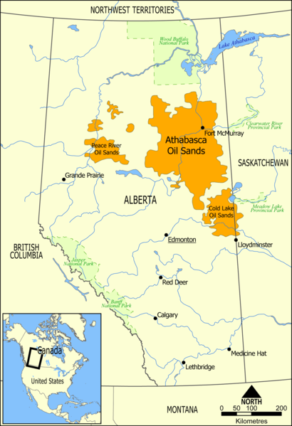
English: This map shows the extent of the oil sands in Alberta, Canada. The three oil sand deposits are known as the Athabasca Oil Sands, the Cold Lake Oil Sands, and the Peace River Oil Sands. |
| วันที่ | |
| แหล่งที่มา | งานของตัว |
| ผู้สร้างสรรค์ | NormanEinstein |
| เวอร์ชันอื่น |
ไฟล์อื่นที่ใช้ไฟล์นี้: Athabasca oil sand mining map 2011.jpg: |
การอนุญาตใช้สิทธิ
| ข้าพเจ้า ผู้ถือลิขสิทธิ์ในงานนี้ ขอมอบงานให้เป็นสาธารณสมบัติ ประกาศนี้มีผลทั่วโลก ในบางประเทศ การกระทำดังกล่าวอาจไม่สามารถทำได้ตามกฎหมาย ข้าพเจ้าอนุญาตให้ทุกคนมีสิทธิ์ในการใช้ไฟล์นี้ในทุกเหตุผลการใช้ โดยไม่มีมีเงื่อนไข เว้นแต่กฎหมายไม่อนุญาตให้ทำเช่นนั้น |
ประวัติไฟล์
คลิกวันที่/เวลาเพื่อดูไฟล์ที่ปรากฏในขณะนั้น
| วันที่/เวลา | รูปย่อ | ขนาด | ผู้ใช้ | ความเห็น | |
|---|---|---|---|---|---|
| ปัจจุบัน | 23:49, 10 พฤษภาคม 2549 | | 1,200 × 1,753 (611 กิโลไบต์) | NormanEinstein | This map shows the extent of the oils sands in Alberta, Canada. The three oil sand deposits are known as the Athabasca Oil Sands, the Cold Lake Oil Sands, and the Peace River Oil Sands. Created by NormanEinstein, May 10, 2006. {{GFDL-self}} [[Category: |
หน้าที่มีภาพนี้
หน้าต่อไปนี้ โยงมาที่ภาพนี้:
การใช้ไฟล์ข้ามโครงการ
วิกิอื่นต่อไปนี้ใช้ไฟล์นี้:
- การใช้บน ar.wikipedia.org
- การใช้บน bg.wikipedia.org
- การใช้บน ca.wikipedia.org
- การใช้บน cs.wikipedia.org
- การใช้บน da.wikipedia.org
- การใช้บน de.wikipedia.org
- การใช้บน el.wikipedia.org
- การใช้บน en.wikipedia.org
- Ernest Manning
- Oil sands
- Athabasca oil sands
- User:NormanEinstein/gallery
- Template:Text-superimpose
- Wabasca oil field
- History of the petroleum industry in Canada (oil sands and heavy oil)
- Kearl Oil Sands Project
- Cold Lake oil sands
- Peace River oil sands
- Oil sands tailings ponds (Canada)
- Tar Sands Healing Walk
- User:Klausronjaen/sandbox
- Georg Naumann
- User:Garrett.Nielsen/sandbox
- Environmental issues in Alberta
- Timeline of the petroleum industry in Alberta
- Template:Text-superimpose/doc
- Template:Text-superimpose/sandbox
- History of the Petroleum industry in Alberta
- Legacy pollution
- User:Spencerladner/Legacy pollution
- การใช้บน en.wikinews.org
- การใช้บน es.wikipedia.org
- การใช้บน fa.wikipedia.org
- การใช้บน fi.wikipedia.org
- การใช้บน fr.wikipedia.org
- การใช้บน gl.wikipedia.org
- การใช้บน he.wikipedia.org
- การใช้บน it.wikipedia.org
- การใช้บน ja.wikipedia.org
ดูการใช้ข้ามโครงการเพิ่มเติมของไฟล์นี้