
ไฟล์:1815 tambora explosion.png

ขนาดของตัวอย่างนี้: 800 × 358 พิกเซล ความละเอียดอื่น: 320 × 143 พิกเซล | 640 × 286 พิกเซล | 1,200 × 537 พิกเซล
ดูภาพที่มีความละเอียดสูงกว่า (1,200 × 537 พิกเซล, ขนาดไฟล์: 720 กิโลไบต์, ชนิดไมม์: image/png)
| รูปภาพหรือไฟล์เสียงนี้ ต้นฉบับอยู่ที่ คอมมอนส์ รายละเอียดด้านล่าง เป็นข้อความที่แสดงผลจาก ไฟล์ต้นฉบับในคอมมอนส์
|
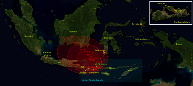
| คำอธิบาย | The 1815 Mount Tambora eruption. The red areas are maps of the thickness of volcanic ashfall. | ||||||||
| แหล่งที่มา | The base map was taken from NASA picture Image:Indonesia_BMNG.png and the isopach maps were traced from Oppenheimer (2003).[1] | ||||||||
| ผู้สร้างสรรค์ | myself | ||||||||
| การอนุญาต (การใช้ไฟล์นี้ใหม่) |
|
||||||||
| เวอร์ชันอื่น |
Deutsch: Von diesem Bild existieren die folgenden Bildbearbeitungen aus der Bilderwerkstatt: English: Retouched versions of this picture from the german Graphic Lab:
|

References
- ↑ Oppenheimer, Clive (2003). "Climatic, environmental and human consequences of the largest known historic eruption: Tambora volcano (Indonesia) 1815". Progress in Physical Geography 27 (2): 230-259.
ประวัติไฟล์
คลิกวันที่/เวลาเพื่อดูไฟล์ที่ปรากฏในขณะนั้น
| วันที่/เวลา | รูปย่อ | ขนาด | ผู้ใช้ | ความเห็น | |
|---|---|---|---|---|---|
| ปัจจุบัน | 20:14, 11 ตุลาคม 2549 | | 1,200 × 537 (720 กิโลไบต์) | Indon~commonswiki | {{Information |Description= The 1815 Mount Tambora eruption. The red areas are maps of the thickness of vulcanic ashfall. |Source=The base map was taken from NASA picture Image:Indonesia_BMNG.png and the isopach maps were traced |
| 20:12, 11 ตุลาคม 2549 |  | 1,200 × 537 (720 กิโลไบต์) | Indon~commonswiki | ||
| 19:50, 11 ตุลาคม 2549 |  | 1,200 × 537 (686 กิโลไบต์) | Indon~commonswiki | {{Information |Description= The 1815 Mount Tambora eruption. The red areas are w:isopach maps of the density of fallen vulcanic ashes. |Source=The base map was taken from NASA picture Image:Indonesia_BMNG.png and the isopach |
หน้าที่มีภาพนี้
หน้าต่อไปนี้ โยงมาที่ภาพนี้:
การใช้ไฟล์ข้ามโครงการ
วิกิอื่นต่อไปนี้ใช้ไฟล์นี้:
- การใช้บน ar.wikipedia.org
- การใช้บน ast.wikipedia.org
- การใช้บน be-tarask.wikipedia.org
- การใช้บน ca.wikipedia.org
- การใช้บน de.wikipedia.org
- การใช้บน en.wikipedia.org
- การใช้บน es.wikipedia.org
- การใช้บน gor.wikipedia.org
- การใช้บน id.wikipedia.org
- การใช้บน lt.wikipedia.org
- การใช้บน ms.wikipedia.org
- การใช้บน ro.wikipedia.org
- การใช้บน sh.wikipedia.org
- การใช้บน sv.wikipedia.org
- การใช้บน tr.wikipedia.org