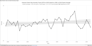
ไฟล์:Southern Hemisphere Sea Ice Extent Anomalies.png
หน้าตา

ขนาดของตัวอย่างนี้: 800 × 457 พิกเซล ความละเอียดอื่น: 320 × 183 พิกเซล | 640 × 366 พิกเซล | 1,260 × 720 พิกเซล
ดูภาพที่มีความละเอียดสูงกว่า (1,260 × 720 พิกเซล, ขนาดไฟล์: 127 กิโลไบต์, ชนิดไมม์: image/png)
ประวัติไฟล์
คลิกวันที่/เวลาเพื่อดูไฟล์ที่ปรากฏในขณะนั้น
| วันที่/เวลา | รูปย่อ | ขนาด | ผู้ใช้ | ความเห็น | |
|---|---|---|---|---|---|
| ปัจจุบัน | 14:28, 22 ตุลาคม 2551 |  | 1,260 × 720 (127 กิโลไบต์) | Splette | {{Information |Description= '''Southern Hemisphere (Antarctic) Sea Ice Extent Anomalies''': Ice extent anomalies are plotted as a time series of percent differences between the total extent for the month in question, and the mean for that month, where the |
| 03:11, 10 มิถุนายน 2551 |  | 1,260 × 720 (142 กิโลไบต์) | Splette | as before | |
| 05:26, 3 ธันวาคม 2550 |  | 1,260 × 720 (127 กิโลไบต์) | Sagredo | {{Information |Description= Southern Hemisphere (Antarctic) Sea Ice Extent Anomalies |Source=http://nsidc.org/data/seaice_index/s_plot.html |Date=October 2007 |Author=National Snow and Ice Data Center |Permission= |other_versions= }} |
หน้าที่มีภาพนี้
หน้าต่อไปนี้ โยงมาที่ภาพนี้:
การใช้ไฟล์ข้ามโครงการ
วิกิอื่นต่อไปนี้ใช้ไฟล์นี้:
- การใช้บน hi.wikipedia.org
- การใช้บน it.wikipedia.org
- การใช้บน ta.wikipedia.org


