
อัตลัสกาตาลา

.jpg)
อัตลัสกาตาลา (กาตาลา: Atles català, เสียงอ่านภาษากาตาลา: [ˈatləs kətəˈla]) เป็นแผนที่โลกสมัยกลางที่น่าจะผลิตขึ้นในช่วงปลายคริสต์ทศวรรษ 1370 หรือต้นคริสต์ทศวรรษ 1380 (ส่วนใหญ่มักลงเป็น ค.ศ. 1375)[1][2] ซึ่งได้รับการกล่าวถึงว่าเป็นแผนที่สำคัญที่สุดที่เขียนเป็นภาษากาตาลาในสมัยกลาง[3][4] และเป็น "สุดยอดผลงานแผนที่สมัยกลาง"[4]
แผนที่นี้ผลิตที่สกุลช่างทำแผนที่มาจอร์กา น่าจะวาดโดยอะบราอัม เกร็สกัส ผู้วาดภาพหนังสือชาวยิวที่ได้รับการขนานนามจากคนร่วมสมัยว่าเป็นปรมาจารย์ด้าน มัปปามุนดี และเข็มทิศ[5] เมื่อถึง ค.ศ. 1380 แผนที่นี้ได้ตกมาอยู่ในหอสมุดหลวงของฝรั่งเศสในรัชสมัยพระเจ้าชาร์ลที่ 5 และในปัจจุบันได้รับการเก็บรักษาไว้ในหอสมุดแห่งชาติฝรั่งเศส เดิมทีอัตลัสกาตาลาประกอบด้วยแผ่นหนังสัตว์ 6 แผ่นที่พับในแนวตั้ง (แต่ละแผ่นมีขนาดกว้างยาว 64.5 โดย 50 ซm [2.12 โดย 1.64 ft]) ใช้สีหลายสี ซึ่งรวมถึงสีทองและเงิน[6] ต่อมาได้รับการนำไปประกอบกับด้านหน้าและด้านหลังของแผงไม้ห้าแผ่น โดยมีปลายปิดทำจากหนังซึ่งเป็นฝีมือของซีมง ว็อทร์ เมื่อประมาณ ค.ศ. 1515 และได้รับการซ่อมแซมใน ค.ศ. 1991[6]
รายละเอียด[แก้]

ส่วนนี้รอเพิ่มเติมข้อมูล คุณสามารถช่วยเพิ่มข้อมูลส่วนนี้ได้ |
ภาพ[แก้]
-
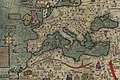 สำเนาสมัยใหม่ของแผนที่ส่วนตะวันตก
 -
 สำเนาสมัยใหม่ของแผนที่ส่วนภูมิภาคเมดิเตอร์เรเนียนตะวันออก
 -
 แผนที่แผ่นแรกที่ทำซ้ำขึ้น
 -
 แผนที่แผ่นที่สองที่ทำซ้ำขึ้น
 -
 บุคคลที่ไม่ปรากฏชื่อ น่าจะเป็นภาพของอะบูบักร์ อิบน์ อุมัร

.jpg)
.jpg)
.jpg)

อ้างอิง[แก้]
- ↑ Ferandez-Armesto, F.F.R. (1995). The European opportunity. Aldershot, Great Britain ; Brookfield, Vt. : Variorum. p. 291. ISBN 978-0-86078-501-9.
The Catalan Atlas is conventionally attributed to 1375, because that year is used as the starting-point for the computation of the Golden Number, but 1376 and 1377 are also mentioned in its accompanying texts; it conforms closely to the description of such an atlas in the French royal library catalogue, dated 1380 [...] The Catalan Atlas can be assigned with some confidence to the late 1370s or the early 1380s.
- ↑ The date "1375" is mentioned in several places in the map: Gunn, Geoffrey C. (15 October 2018). Overcoming Ptolemy: The Revelation of an Asian World Region (ภาษาอังกฤษ). Rowman & Littlefield. p. 67. ISBN 978-1-4985-9014-3.
- ↑ Cecil Roth (1940). The Jewish Contribution To Civilization. Harper. pp. 69–72. ISBN 9781443725231. สืบค้นเมื่อ 2010-04-28.
- ↑ 4.0 4.1 Clayton J. Drees (2001). The Late Medieval Age of Crisis and Renewal, 1300–1500: A Biographical Dictionary (The Great Cultural Eras of the Western World). Greenwood. pp. 119–120. ISBN 0-313-30588-9.
- ↑ Harwood, Jeremy (2006). To the Ends of the Earth: 100 Maps that Changed the World. F+W Publications Inc.
- ↑ 6.0 6.1 "Espagnol 30". Bibliothèque nationale de France (ภาษาฝรั่งเศส).
อ่านเพิ่ม[แก้]
- Edson, Evelyn (2007). The World Map 1300-1492. Baltimore: Johns Hopkins University Press. pp. 74–86. ISBN 978-0801885891.
แหล่งข้อมูลอื่น[แก้]
- Bibliothèque nationale de France – L'Atlas Catalan (ในภาษาฝรั่งเศส)
- Complete transcription of the Catalan language text, and translation to French (1839): Buchon, Jean Alexandre (2011). Notice D'un Atlas En Langue Catalane, Manuscrit de L'An 1375 Conservé Parmi Les Manuscrits de La Bibliothèque Royale Sous Le Numéro 6816, Fonds Ancien (PDF). p. 135. ISBN 978-1271741458.
- The Catalan Atlas (ในภาษาอังกฤษ) [via archive.org]
- www.cresquesproject.net – translation of the works of Riera i Sans and Gabriel Llompart on the Jewish Majorcan Map-makers of the Late Middle Ages (ในภาษาอังกฤษ)
- Abraham Cresques ? Atlas de cartes marines, dit [Atlas catalan], gallica.bnf.fr
| นานาชาติ | |
|---|---|
| ประจำชาติ | |