
แม่น้ำคาบูล
| คาบูล | |
|---|---|
 ภาพถ่ายทางอากาศของแม่น้ำคาบูลในบริเวณที่ราบน้ำท่วมถึงทางตะวันออกของคาบูล ประเทศอัฟกานิสถาน | |
 เส้นทางแม่น้ำคาบูล [1] | |
 ปากแม่น้ำคาบูลในประเทศปากีสถาน | |
| ที่ตั้ง | |
| ประเทศ | อัฟกานิสถานและปากีสถาน |
| เมือง | คาบูล, Surobi, จะลาลาบาด (อัฟกานิสถาน); เปศวาร์, ชาร์ซัดดาฮ์, Nowshera (ปากีสถาน) |
| ลักษณะทางกายภาพ | |
| ต้นน้ำ | เทือกเขาฮินดูกูช |
| • ตำแหน่ง | จังหวัดมัยดานวาร์ดัก ประเทศอัฟกานิสถาน |
| • พิกัดภูมิศาสตร์ | 34°21′25″N 68°50′21″E / 34.357°N 68.8392°E |
| • ระดับความสูง | 2,400 เมตร (7,900 ฟุต) |
| ปากน้ำ | แม่น้ำสินธุ |
• ตำแหน่ง | Attock แคว้นปัญจาบ ประเทศปากีสถาน |
• พิกัด | 33°55′0″N 72°13′56″E / 33.91667°N 72.23222°E |
| ความยาว | 700 กิโลเมตร (430 ไมล์) |
| พื้นที่ลุ่มน้ำ | 70,500 ตารางกิโลเมตร (27,200 ตารางไมล์) |
| ลุ่มน้ำ | |
| ลำน้ำสาขา | |
| • ซ้าย | แม่น้ำปัญจชีร์, แม่น้ำ Alingar, แม่น้ำกุนาร์, แม่น้ำสวัต |
| • ขวา | แม่น้ำโลการ์, แม่น้ำ Surkhab, แม่น้ำบารา |
แม่น้ำคาบูล (ปาทาน: د کابل سیند; ดารี: دریای کابل; ฮินดี: काबुल नदी; สมัยคลาสสิกเรียก โคเฟน (Cophen, /ˈkoʊfeɪn/)) เป็นแม่น้ำทางตะวันออกเฉียงใต้ของอัฟกานิสถานมีกำเนิดจากเทือกเขาบาบา เป็นแม่น้ำสายหลักในภาคตะวันออกของอัฟกานิสถาน ไหลผ่านจังหวัดคาบูลไปบรรจบกับสาขาที่ไหลมาจากฉนวนวาคาน ไหลเข้าสู่ประเทศปากีสถานทางด้านเหนือของช่องเขาไคเบอร์เป็นระยะทางรวม 700 กิโลเมตร (430 ไมล์) แล้วจึงรวมกับแม่น้ำสินธุ
น้ำในแม่น้ำคาบูลในช่วงฤดูร้อนมาจากหิมะที่ละลาย สาขาที่ใหญ่ที่สุดเป็นแม่น้ำกุนาร์ ซึ่งเริ่มต้นจากแม่น้ำมัสตุช ไหลมาจากธารน้ำแข็งเชียนตาร์ในไครัล และหลังจากที่ไหลลงใต้เข้าไปในอัฟกานิสถาน รวมกับแม่น้ำบัชกัลที่ไหลจากนูเรสถาน แม่น้ำกุนาร์นี้ไปบรรจบกับแม่น้ำคาบูลที่จาลาลาบาด ทั้ง ๆ ที่แม่น้ำกุนาร์มีปริมาณน้ำมากกว่าแม่น้ำคาบูล แต่ยังคงเรียกชื่อเป็นแม่น้ำคาบูลหลังจากที่บรรจบกัน เป็นเพราะมีนัยสำคัญทางการเมืองและประวัติศาสตร์ของชื่อ
ประวัติศาสตร์[แก้]
การรุกรานสู่เอเชียของพระเจ้าอเล็กซานเดอร์มหาราช[แก้]
ในการทัพของอเล็กซานเดอร์โดยแอร์เรียน แม่น้ำคาบูลมีชื่อเรียกว่า Κωφήν Kōphēn (รูปละติน Cophen)[1][2][3][4]
สมัยใหม่[แก้]
ส่วนนี้รอเพิ่มเติมข้อมูล คุณสามารถช่วยเพิ่มข้อมูลส่วนนี้ได้ |
ศัพทมูลวิทยา[แก้]
ในภาษาสันสกฤตและอเวสตะ[แก้]
คำว่า กุภา (Kubhā) ซึ่งเป็นชื่อเก่าของแม่น้ำเป็นทั้งคำในภาษาสันสกฤตและภาษาอเวสตะ ภายหลังพัฒนาไปเป็น คาบูล[5][6]
อัลบิรูนี[แก้]
อัลบิรูนีเรียกแม่น้ำสายนี้ว่า "แม่น้ำแห่งฆอร์วันด์"[7] ต่อมาชื่อของแม่น้ำสายนี้เปลี่ยนเป็นแม่น้ำตามชื่อจังหวัดคาบูล[7]
ภาพ[แก้]
-
 แม่น้ำคาบูลในเมืองคาบูล ค.ศ. 1966
 -
 แม่น้ำคาบูลในเมืองคาบูล ค.ศ. 1982
 -
 แม่น้ำคาบูลในเมืองคาบูล ค.ศ. 2009 ซึ่งแห้งขอด
 -
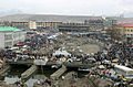 แม่น้ำที่แห้งขอดใจกลางเมืองคาบูล
 -
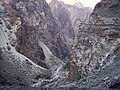
 หุบเขาริมแม่น้ำคาบูล
 -
 ช่องเขาริมแม่น้ำคาบูล ขนานกับถนนคาบูล-จะลาลาบาด
 -
 แม่น้ำคาบูลในบริเวณสะพานเบฮ์ซูด จะลาลาบาด ค.ศ. 2009
 -
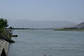 แม่น้ำคาบูลในบริเวณสะพานเบฮ์ซูด จะลาลาบาด ค.ศ. 2009
 -
 ถ้ำพุทธ ซึ่งถูกเจาะเข้าไปในหน้าผาทางเหนือของแม่น้ำคาบูล
 -
 เขื่อนกั้นแม่น้ำ
 -
 แม่น้ำคาบูลที่สะพานเบฮ์ซูด จะลาลาบาด


.jpg)

อ้างอิง[แก้]
- ↑ Arrian, John Rooke; Arrian (1813). "A brief account of all the authors who have touched upon the history of Alexander". Arrian's History of the expedition of Alexander the Great: and conquest of Persia. แปลโดย Rooke, John (2nd ed.). J. Davis.
- ↑ Cawthorne, Nigel (2004). Alexander the Great. Haus Publishing. ISBN 1-904341-56-X.
- ↑ Heckel, Waldemar (2003). The wars of Alexander the Great, 336-323 B.C. Taylor & Francis. ISBN 0-415-96855-0.
- ↑ Arrian (2005). Romm, James S. (บ.ก.). Alexander the Great: selections from Arrian, Diodorus, Plutarch, and Quintus Curtius. แปลโดย Mensch, Pamela. Hackett Publishing. ISBN 0-87220-727-7.
- ↑ Ramesh Chandra Majumdar, Achut Dattatrya Pusalker, A. K. Majumdar, Dilip Kumar Ghose, Bharatiya Vidya Bhavan, Vishvanath Govind Dighe Published by Bharatiya Vidya Bhavan (1962). The History and Culture of the Indian People : The Vedic age. p. 247.
The Kubha is the modern Kabul river which flows into the Indus a little above Attock and receives at Prang the joint flow of its tributaries the Swat (Swastu) and Gauri
{{cite book}}: CS1 maint: multiple names: authors list (ลิงก์) - ↑ Muir, John. Original Sanskrit Texts on the Origin and History of the People of India. p. 352.
'In the older parts of the Rigved the Indian people appear to be settled on the north western border of India, in the Punjab and even beyond the Punjab on the borders of the Kubha river the Kowpher in Kabul. The gradual diffusion of these people from this point towards the east, beyond the Saraswati and Hindustan as far as the Ganges, can be traced almost step by step in the later portions of the Vedic writings
- ↑ 7.0 7.1 Bosworth, C.E. (1999). "Kabul". Encyclopaedia of Islam (CD-ROM Edition v. 1.0 ed.). Leiden, The Netherlands: Koninklijke Brill NV.
แหล่งข้อมูลอื่น[แก้]
 . สารานุกรมบริตานิกา ค.ศ. 1911 (11 ed.). 1911.
33°55′0″N 72°13′56″E / 33.91667°N 72.23222°E
| นานาชาติ | |
|---|---|
| ประจำชาติ | |