ผลต่างระหว่างรุ่นของ "ยุทธการที่วอเตอร์ลู"
ไม่มีความย่อการแก้ไข |
|||
| บรรทัด 38: | บรรทัด 38: | ||
==สมรภูมิ== |
==สมรภูมิ== |
||
[[Image:Belgique Butte du Lion dit de Waterloo.jpg|thumb|right|200px| ''มอร์น แปลน'' ที่มีชื่อเสียงโดย [[วิกเตอร์ อูโก]]และ[[ไลออนส์ โมนด์]].]] |
[[Image:Belgique Butte du Lion dit de Waterloo.jpg|thumb|right|200px| ''มอร์น แปลน'' ที่มีชื่อเสียงโดย [[วิกเตอร์ อูโก]]และ[[ไลออนส์ โมนด์]].]] |
||
ทางยอดเขามีถนน[[Ohain, Belgium|โออัง]] และ[[หุบเหวตื้น]]. Near the crossroads with the Brussels road was a large elm tree that was roughly in the centre of Wellington's position and served as his command post for much of the day. Wellington deployed his infantry in a line just behind the crest of the ridge following the Ohain road. Using the [[Reverse slope defence|reverse slope]], as he had many times previously, Wellington concealed his strength from the French, with the exception of his skirmishers and artillery.<ref>{{Harvnb|Barbero|2005|pp=78,79}}.</ref> The length of front of the battlefield was also relatively short at {{convert|2.5|mi|km}}. This allowed Wellington to draw up his forces in depth, which he did in the centre and on the right, all the way towards the village of [[Braine-l'Alleud]], in the expectation that the Prussians would reinforce his left during the day.<ref>{{Harvnb|Barbero|2005|p=80}}.</ref> |
|||
In front of the ridge, there were three positions that could be fortified. On the extreme right were the |
In front of the ridge, there were three positions that could be fortified. On the extreme right were the château, garden, and orchard of [[Hougoumont (farmhouse)|อูโกมองต์]]. This was a large and well-built country house, initially hidden in trees. The house faced north along a sunken, covered lane (usually described by the British as "the hollow-way") along which it could be supplied. On the extreme left was the hamlet of Papelotte. Both Hougoumont and Papelotte were fortified and garrisoned, and thus anchored Wellington's flanks securely. Papelotte also commanded the road to Wavre that the Prussians would use to send reinforcements to Wellington's position. On the western side of the main road, and in front of the rest of Wellington's line, was the farmhouse and orchard of [[La Haye Sainte]], which was garrisoned with 400 light infantry of the [[King's German Legion]].<ref>{{Harvnb|Barbero|2005|p=149}}.</ref> On the opposite side of the road was a disused sand quarry, where the [[95th Rifles]] were posted as sharpshooters.<ref>{{Harvnb|Parry|1900|p=58}}.</ref> |
||
This position presented a formidable challenge to an attacker. Any attempt to turn Wellington's right would entail taking the entrenched Hougoumont position; any attack on his right centre would mean the attackers would have to march between [[Enfilade and defilade|enfilading fire]] from Hougoumont and La Haye Sainte. On the left, any attack would also be enfiladed by fire from La Haye Sainte and its adjoining sandpit, and any attempt at turning the left flank would entail fighting through the streets and hedgerows of Papelotte, and some very wet ground.<ref>{{Harvnb|Barbero|2005|pp=141,235}}.</ref> |
This position presented a formidable challenge to an attacker. Any attempt to turn Wellington's right would entail taking the entrenched Hougoumont position; any attack on his right centre would mean the attackers would have to march between [[Enfilade and defilade|enfilading fire]] from Hougoumont and La Haye Sainte. On the left, any attack would also be enfiladed by fire from La Haye Sainte and its adjoining sandpit, and any attempt at turning the left flank would entail fighting through the streets and hedgerows of Papelotte, and some very wet ground.<ref>{{Harvnb|Barbero|2005|pp=141,235}}.</ref> |
||
รุ่นแก้ไขเมื่อ 18:24, 3 กันยายน 2556
| ยุทธการวอเตอร์ลู | |||||||
|---|---|---|---|---|---|---|---|
| ส่วนหนึ่งของ สงครามเจ็ดพันธมิตร | |||||||
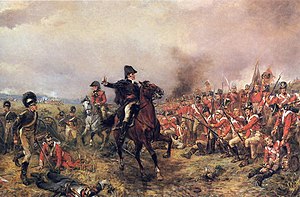
 Wellington at Waterloo ผลงานของ โรเบิร์ต อเล็กซานเดอร์ ฮิลลิงฟอร์ด | |||||||
| |||||||
| คู่สงคราม | |||||||
|
|
สัมพันธมิตรครั้งที่ 7: | ||||||
| ผู้บังคับบัญชาและผู้นำ | |||||||
|
|
| ||||||
| กำลัง | |||||||
| 72,000[1] |
อังกฤษ-พันธมิตร: 68,000[1] ปรัสเซีย: 50,000[2] | ||||||
| ความสูญเสีย | |||||||
|
ตาย/บาดเจ็บ 25,000 คน ตกเป็นเชลย 7,000 คน สูญหาย 15,000[3] | ตาย/บาดเจ็บ 22,000 คน[4] | ||||||
ยุทธการที่วอเตอร์ลู เกิดขึ้นในวันอาทิตย์ที่ 18 มิถุนายน 1815 ที่ เมืองวอเตอร์ลู ซึ่งปัจจุบันอยู่ในประเทศเบลเยี่ยม, ในขณะนั้นอยู่ภายใต้การปกครองของ สหราชอาณาจักรเนเธอร์แลนด์. กองทัพแห่งฝรั่งเศสยุคจักรพรรดิที่ 1 ของจักรพรรดินโปเลียน ได้ปราชัยแก่กองทัพพันธมิตรต่อต้านนโปเลียนที่ 7, ภายใต้การนำทัพ แองโกลของ ดยุกแห่งเวลลิงตัน รวมกับกองทัพปรัสเซีย ของเกบฮาร์ด ฟอน บลือเชอร์ซึ่งเป็นการสู้รบที่ยิ่งใหญ่ที่สุดของเคมเปญวอเตอร์ลู ผลของการสู้รบทำให้นโปเลียนสิ้นสุดอำนาจการเป็นจักรพรรดิ หยุดการขึ้นสู่อำนาจ 100 วัน และนโปเลียนถูกเนรเทศไปเกาะเซนต์เฮเลนา
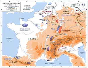
การกลับสู่อำนาจของนโปเลียนในปี 1815 ทำให้รัฐต่างๆ ร่วมกันต่อต้านนโปเลียนเป็นครั้งที่ 7. กองทัพจำนวนมากของเวลเลสลีย์ และบลือเชอร์ได้ตั้งอยู่ทางตะวันออกเฉียงเหนือของฝรั่งเศส นโปเลียนวางแผนเข้าโจมตีเพื่อป้องกันไม่ให้กองทัพทั้งสอง เข้ารวมกับกองทัพของรัฐต่างๆ การตัดสินใจนี้เรียกว่าเคมเปญที่วอเตอร์ลู (16–19 มิถุนายน 1815) เวลลิงตันเคยกล่าวไว้ว่า สงครามนี้เป็น "the nearest-run thing you ever saw in your life" .[5]
นโปเลียนได้ชะลอการโจมตีถึงตอนเที่ยงวันที่ 18 เพื่อให้พื้นแห้ง ในขณะที่กองทัำพของเวลลิงตันได้ประจำตำแหน่งไปตามถนนที่เนินมงต์-แซงต์-ฌอง ตั้งรับการโจมตีของฝรั่งเศสจนถึงตอนเย็น กองทัพของบลือเชอร์ได้มาถึงและเข้าโจมตีทางขวาของกองทัพฝรั่งเศส ร่วมกับกองทัพของเวลลิงตันที่ได้เข้าโจมตีกองทัพฝรั่งเศสจนหมดสภาพในการรบ กองกำลังผสมได้เข้าสู่ประเทศฝรั่งเศสและคืนอำนาจแก่หลุยส์ที่ 18 แห่งฝรั่งเศส นโปเลียนถูกถอดจากอำนาจและถูกเนรเทศไปเกาะเซนต์เฮเลนา
ปัจจุบันสมรภูมินี้อยู่ในประเทศเบลเยี่ยม ระยะทางประมาณ 8 ไมล์ (13 กิโลเมตร) จากทิศใต้ไปตะวันออกเฉียงใต้ของกรุงบรัสเซล และ 1 ไมล์ (1.6 กิโลเมตร) จากเมืองวอเตอร์ลู ปัจจุบันมีรูปปั้นไลออนส์โมนด์ตั้งอยู่
ต้นเหตุ

วันที่ 13 มีนาคม 1815, 6 วันก่อนนโปเลียนเดินทางถึงปารีส, สภาคอนเกรสแห่งเวียนนาประกาศให้นโปเลียนเป็นคนนอกกฏหมาย.[6] สี่วันต่อมา สหราชอาณาจักร, รัสเซีย, ออสเตรีย, และ ปรัสเซีย ได้ยกกองทัพมาเพื่อกำจัดอำนาจของนโปเลียน[7] นโปเลียนทราบว่า ถ้าเขาไม่สามารถป้องกันการโจมตีของมพันธมิตรต่อต้านนโปเลียนในการโจมตีฝรั่งเศสได้แล้ว เขาต้องโจมตีกองทัพของพันธมิตรก่อนที่จะยกทัพมา เพื่อรักษาอำนาจที่ตนมี ถ้าหากเขาสามารถโจมตีกองกำลังผสมที่อยู่ทางตอนใต้ของกรุงบรัสเซล ได้สำเร็จแล้ว อาจจะทำให้กองทัพอังกฤษถอยทัพออกไปยังเกาะบริเตน และทำให้กองทัพปรัสเซียพ่ายแพ้
เหตุผลอีกประการหนึ่งคือในเขตนั้นมีกลุ่มผู้สนับสนุนที่ใช้ภาษาฝรั่งเศสอยู่ (Francophone) ชัยชนะอาจทำให้เกิดการเข้าร่วมกับกองทัพฝรั่งเศส อีกประการหนึ่ง กองทัพอังกฤษที่นั่นเป็นทหารใหม่ กองทัพจำนวนมากที่เคยรบสงครามคาบสมุทรสเปนได้ถูกส่งไปประจำการที่อเมริกาในสงครามปี 1812[8]


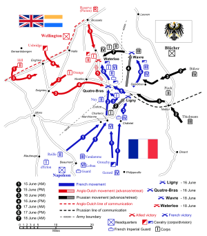
การยกพลกองทัพไปผ่านมองส์ไปยังบรัสเซลส์ มีจุดประสงค์เพื่อตั้งรับการโจมตีนของนโปเลียน [9] การทำเช่นนี้ทำให้เวลลินตันไม่สามารถติต่อกับฐานบัญชาการที่ออสเตนด์ แต่กองทัพของเขาจะใกล้กับบลือเชอร์มาก ฝั่งซ้ายของกองทัพควบคุมโดยมิเชล เนย์ ฝั่งขวาควบคุมโดยมาร์เชลกรูชี กองทัพฝรั่งเศสได้เข้าโจมตีป้อมของกลุ่มพัทธมิตร ในช่วงรุ่งอรุณของวันที่ 15 มิถุนายน ที่ชาร์เลอรัว
สมรภูมิ

ทางยอดเขามีถนนโออัง และหุบเหวตื้น. Near the crossroads with the Brussels road was a large elm tree that was roughly in the centre of Wellington's position and served as his command post for much of the day. Wellington deployed his infantry in a line just behind the crest of the ridge following the Ohain road. Using the reverse slope, as he had many times previously, Wellington concealed his strength from the French, with the exception of his skirmishers and artillery.[10] The length of front of the battlefield was also relatively short at 2.5 ไมล์ (4.0 กิโลเมตร). This allowed Wellington to draw up his forces in depth, which he did in the centre and on the right, all the way towards the village of Braine-l'Alleud, in the expectation that the Prussians would reinforce his left during the day.[11]
In front of the ridge, there were three positions that could be fortified. On the extreme right were the château, garden, and orchard of อูโกมองต์. This was a large and well-built country house, initially hidden in trees. The house faced north along a sunken, covered lane (usually described by the British as "the hollow-way") along which it could be supplied. On the extreme left was the hamlet of Papelotte. Both Hougoumont and Papelotte were fortified and garrisoned, and thus anchored Wellington's flanks securely. Papelotte also commanded the road to Wavre that the Prussians would use to send reinforcements to Wellington's position. On the western side of the main road, and in front of the rest of Wellington's line, was the farmhouse and orchard of La Haye Sainte, which was garrisoned with 400 light infantry of the King's German Legion.[12] On the opposite side of the road was a disused sand quarry, where the 95th Rifles were posted as sharpshooters.[13] This position presented a formidable challenge to an attacker. Any attempt to turn Wellington's right would entail taking the entrenched Hougoumont position; any attack on his right centre would mean the attackers would have to march between enfilading fire from Hougoumont and La Haye Sainte. On the left, any attack would also be enfiladed by fire from La Haye Sainte and its adjoining sandpit, and any attempt at turning the left flank would entail fighting through the streets and hedgerows of Papelotte, and some very wet ground.[14]
The French army formed on the slopes of another ridge to the south. Napoleon could not see Wellington's positions, so he drew his forces up symmetrically about the Brussels road. On the right was I Corps under d'Erlon with 16,000 infantry and 1,500 cavalry, plus a cavalry reserve of 4,700. On the left was II Corps under Reille with 13,000 infantry, and 1,300 cavalry, and a cavalry reserve of 4,600. In the centre about the road south of the inn La Belle Alliance were a reserve including Lobau's VI Corps with 6,000 men, the 13,000 infantry of the Imperial Guard, and a cavalry reserve of 2,000.[15] In the right rear of the French position was the substantial village of Plancenoit, and at the extreme right, the Bois de Paris wood. Napoleon initially commanded the battle from Rossomme farm, where he could see the entire battlefield, but moved to a position near La Belle Alliance early in the afternoon. Command on the battlefield (which was largely hidden from his view) was delegated to Ney.[16]
อ้างอิง
- ↑ 1.0 1.1 Hofschröer, pp. 72–73
- ↑ Chesney, p. 4
- ↑ Barbero, p. 420
- ↑ Barbero, p. 419
กองทัพของเวลลิงตัน: ตาย 3,500 คน; บาดเจ็บ 10,200 คน; สูญหาย 3,300 คน
Blücher's army: ตาย 1,200 คน; บาดเจ็บ 4,400 คน; สูญหาย 1,400 คน - ↑ Wikiquote:Wellington citing Creevey Papers, ch. x, p. 236
- ↑ Timeline: The Congress of Vienna, the Hundred Days, and Napoleon's Exile on St Helena, Center of Digital Initiatives, Brown University Library
- ↑ Hamilton-Williams 1993, p. 59
- ↑ Chandler 1966, pp. 1016, 1017, 1093
- ↑ Siborne 1990, p. 82.
- ↑ Barbero 2005, pp. 78, 79.
- ↑ Barbero 2005, p. 80.
- ↑ Barbero 2005, p. 149.
- ↑ Parry 1900, p. 58.
- ↑ Barbero 2005, pp. 141, 235.
- ↑ Barbero 2005, pp. 83–85.
- ↑ Barbero 2005, p. 91.
แม่แบบ:Link FA แม่แบบ:Link FA แม่แบบ:Link GA แม่แบบ:Link GA แม่แบบ:Link FA
