
ไฟล์:US Secession map 1863 (BlankMap derived).png

ขนาดของตัวอย่างนี้: 800 × 488 พิกเซล ความละเอียดอื่น: 320 × 195 พิกเซล | 640 × 390 พิกเซล | 841 × 513 พิกเซล
ดูภาพที่มีความละเอียดสูงกว่า (841 × 513 พิกเซล, ขนาดไฟล์: 24 กิโลไบต์, ชนิดไมม์: image/png)
| รูปภาพหรือไฟล์เสียงนี้ ต้นฉบับอยู่ที่ คอมมอนส์ รายละเอียดด้านล่าง เป็นข้อความที่แสดงผลจาก ไฟล์ต้นฉบับในคอมมอนส์
|
.png)

|
ภาพแผนที่ระบุตำแหน่งนี้ ควรจะถูกสร้างใหม่เป็นกราฟิกส์เวกเตอร์ ซึ่งมีข้อดีอีกหลายประการ ดูเพิ่มเติมที่คอมมอนส์:สื่อต้องการเก็บกวาดสำหรับสารสนเทศเพิ่มเติม หากภาพนี้มีในรูปแบบกราฟิกส์เวกเตอร์อยู่แล้ว กรุณาอัปโหลดและแทนที่แม่แบบนี้ด้วย
{{vector version available|ชื่อภาพใหม่}}
แนะนำเป็นอย่างยิ่งให้ตั้งชื่อไฟล์เวกเตอร์ใหม่นั้นในรูปแบบ "US Secession map 1863 (BlankMap derived).svg" แล้วใส่แม่แบบ Vector version available (หรือ Vva) ซึ่งไม่ต้องใช้พารามิเตอร์ ชื่อภาพใหม่ |
ความย่อ
| คำอธิบาย |
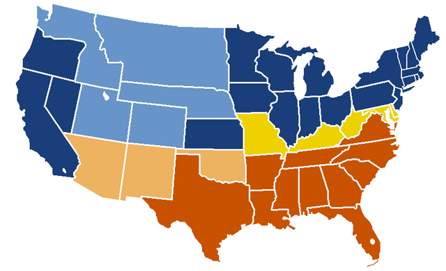
English: United States map of 1863, show affiliation of states and territories regarding the Secession War (Civil War.) Legend:
Union states Union territories not permitting slavery Border Union states, permitting slavery Confederate states Union territories permitting slavery (claimed by Confederacy) |
| วันที่ | original upload date: 19:04, 24 February 2007 |
| แหล่งที่มา |
|
| ผู้สร้างสรรค์ | w:en:Porsche997SBS (คุย | ส่วนร่วม) |
การอนุญาตใช้สิทธิ
This map was obtained from an edition of the National Atlas of the United States. Like almost all works of the U.S. federal government, works from the National Atlas are in the public domain in the United States.
Online access: NationalAtlas.gov | 1970 print edition: Library of Congress, Perry-Castañeda Library
|
บันทึกการอัพโหลด
| date/time | username | resolution | size | edit summary |
|---|---|---|---|---|
| 19:04, 24 February 2007 | w:en:User:Porsche997SBS | 841×513 | 24 KB | trimming blankness |
| 18:59, 24 February 2007 | w:en:User:Porsche997SBS | 841×580 | 25 KB | don't need that |
| 18:55, 24 February 2007 | w:en:User:Porsche997SBS | 841×580 | 29 KB | format based on [http://en.wikipedia.org/wiki/Image:BlankMap-USA-states.PNG this image]; information from [http://en.wikipedia.org/wiki/Image:US_Secession_map_1865.svg this image]; see description pages there |
Image description page history
| link | date/time | username | edit summary |
|---|---|---|---|
| http://en.wikipedia.org/w/index.php?title=Image:US_Secession_map_1865_(BlankMap_derived).PNG&redirect=no&oldid=110635613 | 07:40, 10 September 2007 | w:en:User:Dmcdevit | |
| http://en.wikipedia.org/w/index.php?title=Image:US_Secession_map_1865_(BlankMap_derived).PNG&redirect=no&oldid=110635613 | 19:02, 24 February 2007 | w:en:User:Porsche997SBS | |
| http://en.wikipedia.org/w/index.php?title=Image:US_Secession_map_1865_(BlankMap_derived).PNG&redirect=no&oldid=110634272 | 18:55, 24 February 2007 | w:en:User:Porsche997SBS | (format based on [http://en.wikipedia.org/wiki/Image:BlankMap-USA-states.PNG this image]; information from [http://en.wikipedia.org/wiki/Image:US_Secession_map_1865.svg this image]; see description pages there) |
.PNG&redirect=no&oldid=110635613)
.PNG&redirect=no&oldid=110634272)
ประวัติไฟล์
คลิกวันที่/เวลาเพื่อดูไฟล์ที่ปรากฏในขณะนั้น
| วันที่/เวลา | รูปย่อ | ขนาด | ผู้ใช้ | ความเห็น | |
|---|---|---|---|---|---|
| ปัจจุบัน | 04:08, 15 มกราคม 2553 | | 841 × 513 (24 กิโลไบต์) | Porsche997SBS | Reverted to version as of 09:03, 14 January 2010--so frustrating |
| 04:07, 15 มกราคม 2553 |  | 841 × 513 (12 กิโลไบต์) | Porsche997SBS | let's try again | |
| 16:03, 14 มกราคม 2553 |  | 841 × 513 (24 กิโลไบต์) | Porsche997SBS | upload error? | |
| 15:52, 14 มกราคม 2553 |  | 841 × 513 (24 กิโลไบต์) | Porsche997SBS | fixing Nebraska, Dakota, and Washington territories and the border between Nevada and Utah | |
| 14:56, 14 มกราคม 2553 |  | 841 × 513 (24 กิโลไบต์) | Porsche997SBS | gray to blue | |
| 15:32, 29 ธันวาคม 2550 |  | 841 × 513 (24 กิโลไบต์) | Porsche997SBS | updating red to grey | |
| 23:45, 13 กันยายน 2550 |  | 841 × 513 (24 กิโลไบต์) | BetacommandBot | Transwiki approved by: w:en:User:Dmcdevit This image was copied from wikipedia:en. The original description was: format based on [http://en.wikipedia.org/wiki/Image:BlankMap-USA-states.PNG this image]; information from [http://en.wikipedia.org/wiki/ |
หน้าที่มีภาพนี้
หน้าต่อไปนี้ โยงมาที่ภาพนี้:
การใช้ไฟล์ข้ามโครงการ
วิกิอื่นต่อไปนี้ใช้ไฟล์นี้:
- การใช้บน anp.wikipedia.org
- การใช้บน ar.wikipedia.org
- การใช้บน azb.wikipedia.org
- การใช้บน cs.wikipedia.org
- การใช้บน eml.wikipedia.org
- การใช้บน en.wikipedia.org
- การใช้บน eo.wikipedia.org
- การใช้บน he.wikipedia.org
- การใช้บน hi.wikipedia.org
- การใช้บน hu.wikipedia.org
- การใช้บน hy.wikipedia.org
- การใช้บน ja.wikipedia.org
- การใช้บน kk.wikipedia.org
- การใช้บน kn.wikipedia.org
- การใช้บน ko.wikipedia.org
- การใช้บน la.wikipedia.org
- การใช้บน lt.wikipedia.org
- การใช้บน ml.wikipedia.org
- การใช้บน pt.wikipedia.org
- การใช้บน ru.wikipedia.org
- การใช้บน si.wikipedia.org
- การใช้บน sk.wikipedia.org
- การใช้บน vi.wikipedia.org
.png)