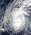
ไฟล์:Typhoon Pongsona (2002).JPG

ขนาดของตัวอย่างนี้: 540 × 600 พิกเซล ความละเอียดอื่น: 216 × 240 พิกเซล | 432 × 480 พิกเซล | 691 × 768 พิกเซล | 922 × 1,024 พิกเซล | 1,843 × 2,048 พิกเซล | 7,200 × 8,000 พิกเซล
ดูภาพที่มีความละเอียดสูงกว่า (7,200 × 8,000 พิกเซล, ขนาดไฟล์: 8.02 เมกะไบต์, ชนิดไมม์: image/jpeg)
ประวัติไฟล์
คลิกวันที่/เวลาเพื่อดูไฟล์ที่ปรากฏในขณะนั้น
| วันที่/เวลา | รูปย่อ | ขนาด | ผู้ใช้ | ความเห็น | |
|---|---|---|---|---|---|
| ปัจจุบัน | 03:26, 4 กันยายน 2549 |  | 7,200 × 8,000 (8.02 เมกะไบต์) | Good kitty | same image capture |
| 09:20, 15 กรกฎาคม 2549 |  | 471 × 393 (40 กิโลไบต์) | Hurricanehink | {{Information |Description=Typhoon Pongsona near landfall on Guam on December 8, 2002 |Source=http://modis-atmos.gsfc.nasa.gov/IMAGES/MOD02/GRANULE/2002_12_08/342.0050.rgb143.jpg |Date=2006-07-14 |Author=MODIS Satellite |Permission={{PD-USGov-NASA}} |othe |
หน้าที่มีภาพนี้
หน้าต่อไปนี้ โยงมาที่ภาพนี้:
การใช้ไฟล์ข้ามโครงการ
วิกิอื่นต่อไปนี้ใช้ไฟล์นี้:
- การใช้บน en.wikipedia.org
- การใช้บน es.wikipedia.org
- การใช้บน fr.wikipedia.org
- การใช้บน ko.wikipedia.org
- การใช้บน pt.wikipedia.org
- การใช้บน zh.wikipedia.org
- 2002年太平洋颱風季
- 颱風鳳仙
- WikiProject:太平洋颱風季/條目/典範條目
- Wikipedia:优良条目/2015年5月
- Talk:颱風鳳仙
- Wikipedia:典范条目/2015年4月
- Wikipedia:优良条目/台风凤仙
- Wikipedia:优良条目/2015年5月15日
- Wikipedia:典范条目/2015年4月14日
- Wikipedia:典范条目/颱風鳳仙
- Portal:美国/特色条目/263
- Wikipedia:典范条目/2017年5月
- Wikipedia:典范条目/2017年5月29日
- User:MCC214/2002年太平洋颱風季
- Wikipedia:典范条目/2019年12月
- Wikipedia:典范条目/2019年12月29日
- User:AndyAndyAndyAlbert/沙盒/Q
- Wikipedia:典范条目/2024年2月
- Wikipedia:典范条目/2024年2月21日


