
ไฟล์:Tiger Bush Niger Corona 1965-12-31.jpg
ขนาดของตัวอย่างนี้: 600 × 600 พิกเซล ความละเอียดอื่น: 240 × 240 พิกเซล | 480 × 480 พิกเซล | 1,000 × 1,000 พิกเซล
ดูภาพที่มีความละเอียดสูงกว่า (1,000 × 1,000 พิกเซล, ขนาดไฟล์: 545 กิโลไบต์, ชนิดไมม์: image/jpeg)
| รูปภาพหรือไฟล์เสียงนี้ ต้นฉบับอยู่ที่ คอมมอนส์ รายละเอียดด้านล่าง เป็นข้อความที่แสดงผลจาก ไฟล์ต้นฉบับในคอมมอนส์
|
ความย่อ
| คำอธิบาย |
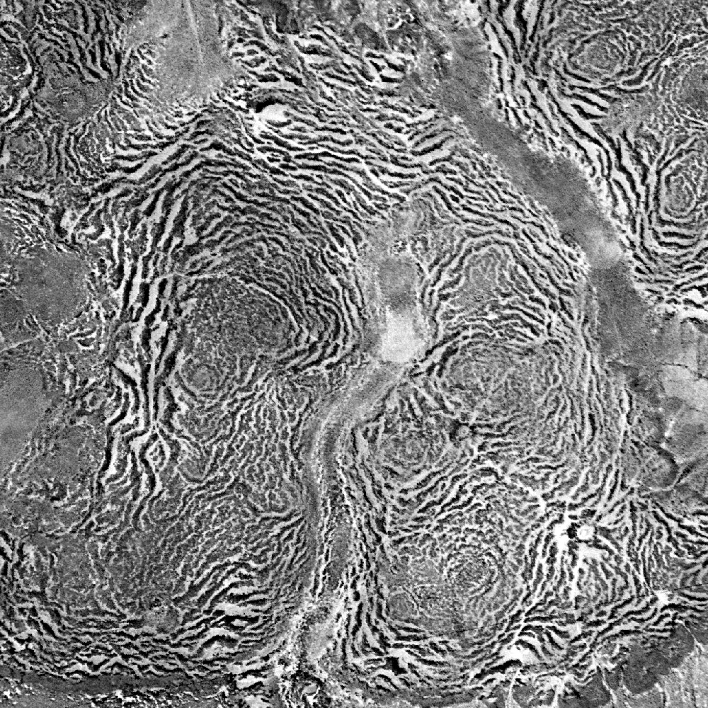
English: Vertical aerial view of a tiger bush plateau in Niger. Vegetation is dominated by Combretum micranthum and Guiera senegalensis. Image size : 5 x 5 km on the ground. Satellite image from the Declassified corona KH-4A national intelligence reconnaissance system, 1965-12-31.
Français : Vue aérienne verticale d'une brousse tigrée au Niger le 31 décembre 1965. La végétation est dominée par Combretum micranthum et Guiera senegalensis. L'image couvre 5 x 5 km de terrain. Image satellite Corona KH-4A déclassifiée. |
| วันที่ | |
| แหล่งที่มา | Data available from the U.S. Geological Survey |
| ผู้สร้างสรรค์ | US Agency |
| ตำแหน่งที่ตั้งกล้อง | | ภาพนี้และภาพอื่น ๆ ณ สถานที่เดียวกันที่ OpenStreetMap |
|---|
การอนุญาตใช้สิทธิ
This image is in the public domain in the United States because it only contains materials that originally came from the United States Geological Survey, an agency of the United States Department of the Interior. For more information, see the official USGS copyright policy.
|
ประวัติไฟล์
คลิกวันที่/เวลาเพื่อดูไฟล์ที่ปรากฏในขณะนั้น
| วันที่/เวลา | รูปย่อ | ขนาด | ผู้ใช้ | ความเห็น | |
|---|---|---|---|---|---|
| ปัจจุบัน | 01:19, 26 กุมภาพันธ์ 2552 | | 1,000 × 1,000 (545 กิโลไบต์) | AlkalIn | {{Information |Description={{en|1=Vertical aerial view of a tiger bush plateau in Niger. Vegetation is dominated by Combretum micranthum and Guiera senegalensis. Image size : 5 x 5 km on the ground. Satellite image from the Declassified corona KH-4A natio |
หน้าที่มีภาพนี้
หน้าต่อไปนี้ โยงมาที่ภาพนี้:
การใช้ไฟล์ข้ามโครงการ
วิกิอื่นต่อไปนี้ใช้ไฟล์นี้:
- การใช้บน cs.wikipedia.org
- การใช้บน de.wikipedia.org
- การใช้บน en.wikipedia.org
- การใช้บน es.wikipedia.org
- การใช้บน fa.wikipedia.org
- การใช้บน fr.wikipedia.org
- การใช้บน fr.wiktionary.org
- การใช้บน he.wikipedia.org
- การใช้บน hy.wikipedia.org
- การใช้บน ja.wikipedia.org
- การใช้บน pt.wikipedia.org
- การใช้บน ru.wikipedia.org
- การใช้บน uk.wikipedia.org
- การใช้บน www.wikidata.org
- การใช้บน zh.wikipedia.org