
ไฟล์:Tessellated Pavement Sunrise Landscape.jpg
ขนาดของตัวอย่างนี้: 800 × 533 พิกเซล ความละเอียดอื่น: 320 × 213 พิกเซล | 640 × 427 พิกเซล | 1,024 × 683 พิกเซล | 1,280 × 853 พิกเซล | 2,560 × 1,706 พิกเซล | 3,587 × 2,391 พิกเซล
ดูภาพที่มีความละเอียดสูงกว่า (3,587 × 2,391 พิกเซล, ขนาดไฟล์: 5.9 เมกะไบต์, ชนิดไมม์: image/jpeg)
| รูปภาพหรือไฟล์เสียงนี้ ต้นฉบับอยู่ที่ คอมมอนส์ รายละเอียดด้านล่าง เป็นข้อความที่แสดงผลจาก ไฟล์ต้นฉบับในคอมมอนส์
|
|

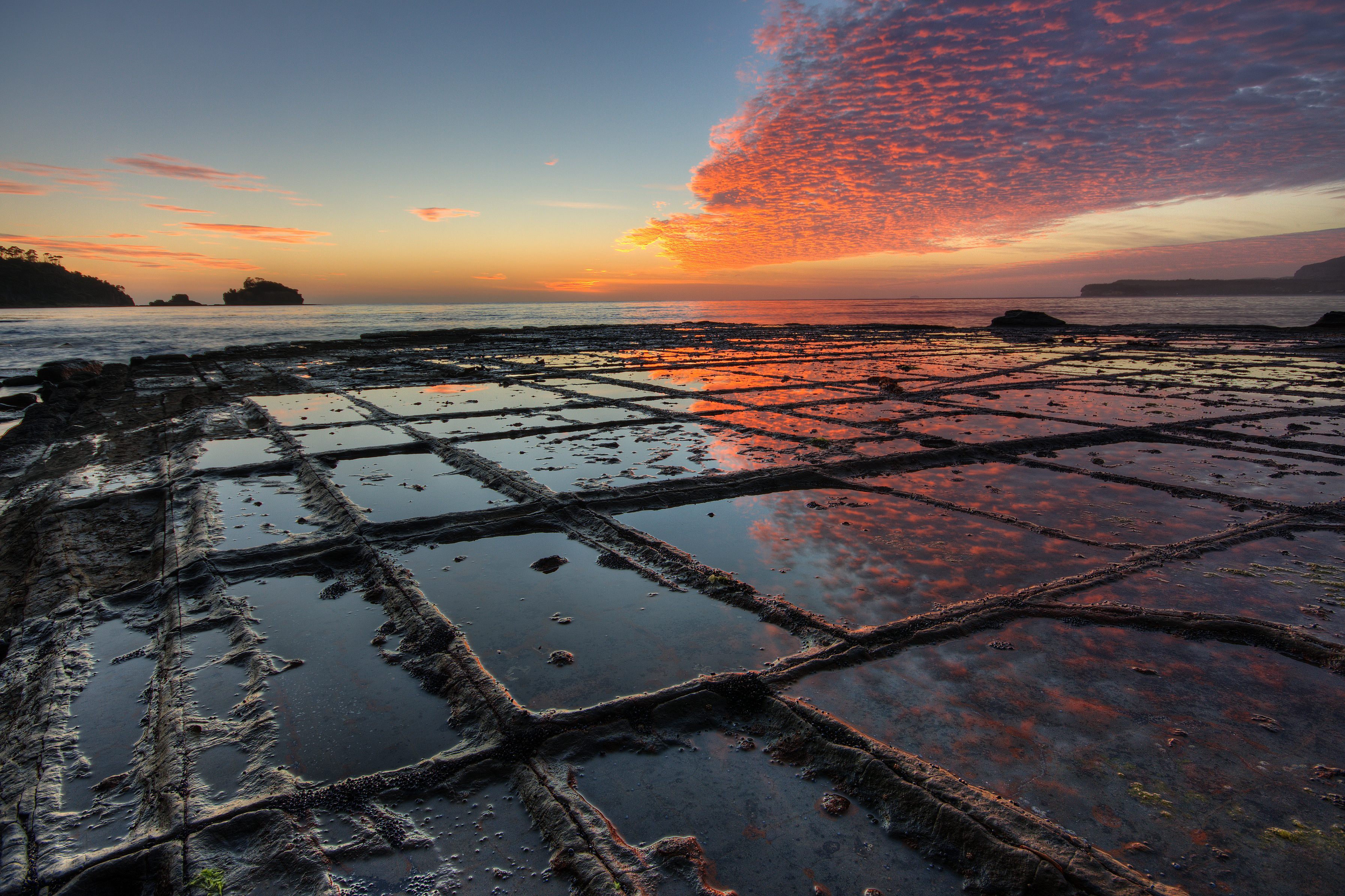
ภาพนี้ได้รับการคัดสรรให้เป็น ภาพประจำวัน สำหรับวันที่ 19 กรกฎาคม พ.ศ. 2552 ภาพดังกล่าวมีคำอธิบายดังต่อไปนี้: English: Sunrise, Tessellated Pavement, Eaglehawk Neck, Tasman Peninsula, Tasmania, Australia. ภาษาอื่น ๆ:
Čeština: Západ slunce nad přírodním mozaikovitým útvarem na šíji Eaglehawk Neck, ležící na australském ostrově Tasmánii English: Sunrise, Tessellated Pavement, Eaglehawk Neck, Tasman Peninsula, Tasmania, Australia. Español: Amanecer sobre el pavimento con forma de mosaico natural en Eaglehawk Neck, Tasmania, Australia. Français : Lever de soleil sur un pavement en mosaïque naturelle à Eaglehawk Neck, en Tasmanie (Australie). Italiano: Levar del Sole su un terreno a mosaico naturale a Eaglehawk Neck, nella penisola di Tasman, Tasmania (Australia). Magyar: Napfelkelte természetes négyszögletes képződmények fölött (Eaglehawk Neck, Tasmán félsziget, Tasmánia, Ausztrália) Malti: Tlugħ ix-xemx fuq art taħt forma ta' mużajk naturali f'Eaglehawk Neck, fit-Tażmanja (Awstralja). Nederlands: zonsopgang boven het tessellated pavement van de landengte Eaglehawk Neck van het Tasman-schiereiland aan zuidoostelijke zijde van het Australische eiland Tasmanië. Een tessellated pavement ("mozaïekterras") is een erosieverschijnsel in vlakgelegen sedimentair gesteente langs sommige oceanen, waarvan Eaglehawk Neck een bekend voorbeeld vormt. Polski: Wschód słońca i mozajkowy chodnik w Eaglehawk Neck, Półwysep Tasmański, Tasmania, Australia. Português: Amanhecer sobre o pavimento de mosaico natural em Eaglehawk Neck, península de Tasman, Austrália. Български: Изгрев над "Мозаечната настилка" на брега на Игълхоук Нек на полусотров Тасман, остров Тасмания, Австралия. Македонски: Изгрејсонце со природно „поплочен“ брег во Иглхок Нек на полуостровот Тасман во Тасманија, Австралија. فارسی : طلوع آفتاب، فرش موزاییکشکل، گردنهٔ ایگلهاوک، شبهجزیرهٔ تاسمان، تاسمانی، استرالیا. |
ความย่อ
| คำอธิบาย |
English: Sunrise, “Tessellated Pavement”, Eaglehawk Neck, Tasman Peninsula, Tasmania, Australia. The „Tesselated Pavement“ is the result of an orthogonal joint pattern in the rock. On the picture it shows the so called “pan formation”, where the rock in the immediate vicinity of the joints is more resistant to erosion than the rock that is more distant to the joints, This is due to alterations of the rock along the joints by hydrothermal (or similar) solutions when the rock was still buried deeply below the surface millions of years ago. When no alterations or alterations that lower the erosional resistivity have taken place in the geological past, the rock along the joints will erode faster than the rock that is more distant to the joints. In that case the so called “loaf formation” of “Tessellated Pavement” will form.
Français : Lever de soleil sur un pavement en mosaïque naturel à Eaglehawk Neck, en Tasmanie (Australie).
Deutsch: Sonnenaufgang bei Ebbe am Eaglehawk Neck, Tasman-Halbinsel, Tasmanien, Australien. Das Gestein zeigt eine natürliche Parkettierung (Tesselation), die auf ein rechtwinkliges Klüftungsmuster im Gestein zurückgeht. Auf dem Foto äußert sie sich in Gestalt sogenannter „Beckenstrukturen“, bei der das Gestein in der unmittelbaren Umgebung der Klüfte erosionsresistenter ist, als das Gestein in größerer Entfernung zu den Klüften. Dies ist wiederum das Ergebnis einer Gesteinsumwandlung entlang der Klüfte durch hydrothermale (oder ähnliche) Lösungen, zu einer Zeit als das Gestein sich noch tief unterhalb der Erdoberfläche befand, vor Millionen von Jahren. Falls keine Umwandlungen stattgefunden haben oder Umwandlungen, die zu einer Herabsetzung der Erosionsresistenz führten, erodiert das Gestein entlang der Klüfte schneller als das Gestein in größerer Entfernung zu den Klüften und es bilden sich „Brotlaibstrukturen“ (im Deutschen auch als Wollsackverwitterung bezeichnet). |
| วันที่ | |
| แหล่งที่มา | งานของตัว |
| ผู้สร้างสรรค์ | JJ Harrison (https://www.jjharrison.com.au/) |
| การอนุญาต (การใช้ไฟล์นี้ใหม่) |
Own work, share alike, attribution required (Creative Commons CC-BY-SA-2.5) |
| เวอร์ชันอื่น |
|


| ตำแหน่งที่ตั้งกล้อง | | ภาพนี้และภาพอื่น ๆ ณ สถานที่เดียวกันที่ OpenStreetMap |
|---|
ข้าพเจ้า ในฐานะผู้ถือลิขสิทธิ์ของภาพหรือสื่อนี้ อนุญาตให้ใช้ภาพหรือสื่อนี้ภายใต้เงื่อนไขต่อไปนี้
ไฟล์นี้อยู่ภายใต้สัญญาอนุญาต ครีเอทีฟคอมมอนส์ แบบแสดงที่มา-อนุญาตแบบเดียวกัน 2.5 ทั่วไป
- คุณสามารถ:
- ที่จะแบ่งปัน – ที่จะทำสำเนา แจกจ่าย และส่งงานดังกล่าวต่อไป
- ที่จะเรียบเรียงใหม่ – ที่จะดัดแปลงงานดังกล่าว
- ภายใต้เงื่อนไขต่อไปนี้:
- แสดงที่มา – คุณต้องให้เกียรติเจ้าของงานอย่างเหมาะสม โดยเพิ่มลิงก์ไปยังสัญญาอนุญาต และระบุหากมีการเปลี่ยนแปลง คุณอาจทำเช่นนี้ได้ในรูปแบบใดก็ได้ตามควร แต่ต้องไม่ใช่ในลักษณะที่แนะว่าผู้ให้อนุญาตสนับสนุนคุณหรือการใช้งานของคุณ
- อนุญาตแบบเดียวกัน – หากคุณดัดแปลง เปลี่ยนรูป หรือต่อเติมงานนี้ คุณต้องใช้สัญญาอนุญาตแบบเดียวกันหรือแบบที่เหมือนกับสัญญาอนุญาตที่ใช้กับงานนี้เท่านั้น

|
ภาพนี้ได้รับการประเมินภายใต้ เกณฑ์ภาพอันทรงคุณค่า และถือว่าเป็น ภาพอันทรงคุณค่าที่สุดในคอมมอนส์ ภายใต้ขอบเขต: Tessellated Pavement Sunrise Landscape, Eaglehawk Neck, Tasmania. คุณสามารถดูการเสนอชื่อได้ ที่นี่. |
ประวัติไฟล์
คลิกวันที่/เวลาเพื่อดูไฟล์ที่ปรากฏในขณะนั้น
| วันที่/เวลา | รูปย่อ | ขนาด | ผู้ใช้ | ความเห็น | |
|---|---|---|---|---|---|
| ปัจจุบัน | 13:26, 2 ธันวาคม 2561 | | 3,587 × 2,391 (5.9 เมกะไบต์) | JJ Harrison | More pixels! |
| 07:55, 24 พฤษภาคม 2552 |  | 1,782 × 1,170 (1.32 เมกะไบต์) | JJ Harrison | untilt | |
| 19:24, 28 มกราคม 2552 |  | 1,794 × 1,196 (1.38 เมกะไบต์) | JJ Harrison | {{Information |Description=Sunrise, Tessellated Pavement, Eaglehawk Neck, Tasman Peninsula, Tasmania, Australia |Source=Own work |Date=28/01/2009 |Author=Noodle snacks |Permission=Own work, share alike, attribution required (Creativ |
หน้าที่มีภาพนี้
หน้าต่อไปนี้ โยงมาที่ภาพนี้:
การใช้ไฟล์ข้ามโครงการ
วิกิอื่นต่อไปนี้ใช้ไฟล์นี้:
- การใช้บน ar.wikipedia.org
- การใช้บน bn.wikipedia.org
- การใช้บน bo.wikipedia.org
- การใช้บน crh.wikipedia.org
- การใช้บน cv.wikipedia.org
- การใช้บน da.wikipedia.org
- การใช้บน de.wikipedia.org
- การใช้บน de.wikivoyage.org
- การใช้บน el.wikipedia.org
- การใช้บน en.wikipedia.org
- Tasmania
- Tasman Peninsula
- Portal:Geography
- Portal:Geography/Featured picture
- Wikipedia:Featured pictures/Places/Landscapes
- Eaglehawk Neck
- Tessellated pavement
- User talk:Fir0002/Guild
- User:Shootbamboo
- Wikipedia:Featured pictures thumbs/15
- User:JJ Harrison/gallery
- Wikipedia:Featured picture candidates/File:Tessellated Pavement Sunrise Landscape.jpg
- Wikipedia:Featured picture candidates/February-2009
- Wikipedia:Wikipedia Signpost/2009-02-16/Features and admins
- User talk:JJ Harrison/Archive1
- Wikipedia:Picture of the day/December 2009
- User talk:בינה תפארת
- Template:POTD/2009-12-20
- User talk:JJ Harrison/Archive3
- Portal:Geography/Featured picture/2010, week 52
- Portal:Geography/Featured picture archive/2010
- User:Fireblazex3
- Wikipedia:WikiProject Geology/Recognized content
- Patterns in nature
- Wikipedia:WikiProject Australia/Featured and good content
- Portal:Geography/Featured picture/2
- User:Mohamed CJ/backgroundgallery
- Wikipedia:Wikipedia Signpost/2009-02-16/SPV
- Wikipedia:WikiProject Geology/Automated list of recognized content
- User:Corinne/subpage
- Wikipedia:WikiProject Australia/2.0/About
- Portal:Australia/Content
- Wikipedia:Wikipedia Signpost/Single/2009-02-16
- การใช้บน en.wikiversity.org
- การใช้บน en.wikivoyage.org
- การใช้บน eo.wikipedia.org
ดูการใช้ข้ามโครงการเพิ่มเติมของไฟล์นี้