ไฟล์:Tembin Aug 20 2012 0235Z (alternate).jpg

ไม่รองรับเนื้อหาของหน้าในภาษาอื่น
จากวิกิพีเดีย สารานุกรมเสรี

ดูภาพที่มีความละเอียดสูงกว่า(5,200 × 6,800 พิกเซล, ขนาดไฟล์: 8.61 เมกะไบต์, ชนิดไมม์: image/jpeg)

Wikimedia Commons logo รูปภาพหรือไฟล์เสียงนี้ ต้นฉบับอยู่ที่ คอมมอนส์ รายละเอียดด้านล่าง เป็นข้อความที่แสดงผลจาก ไฟล์ต้นฉบับในคอมมอนส์
คอมมอนส์เป็นเว็บไซต์ในโครงการสำหรับเก็บรวบรวมสื่อเสรี ที่ คุณสามารถช่วยได้

ความย่อ

คำอธิบาย
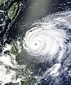
English: After four other Typhoons—Saola, Damrey, Haikui, and Kai-tak—made landfall in eastern China in just three weeks, Typhoon Tembin appeared ready to do the same. Tembin formed as a tropical depression over the western Pacific Ocean on August 19, 2012, and strengthened to a typhoon the next day.

The Moderate Resolution Imaging Spectroradiometer (MODIS) on NASA’s Terra satellite captured this natural-color image on August 20. Sporting a well-defined eye, Tembin hovered over the ocean just east of the Philippine island of Luzon. Although next to the Philippines, Tembin was not actually forecast to make landfall there. The U.S. Navy’s Joint Typhoon Warning Center (JTWC) forecast that Tembin would head northward before turning west and coming ashore in Taiwan and China. Focus Taiwan News Channel reported that Tembin might make landfall on Taiwan’s east coast on August 23.

The same day that MODIS took this picture, the JTWC reported that Tembin was a powerful storm. Located about 320 nautical miles (595 kilometers) northeast of Manila, Tembin had maximum sustained winds of 95 knots (175 kilometers per hour) and gusts up to 115 knots (215 kilometers per hour). Over the next 36 hours, Tembin was expected to strengthen, developing maximum sustained winds of 120 knots (220 kilometers per hour) and gusts up to 145 knots (270 kilometers per hour).
วันที่
แหล่งที่มา http://lance-modis.eosdis.nasa.gov/wms/?zoom=5&lat=-16.87793&lon=160.16895&layers=B0000FFFFT&datum1=08/20/2012
ผู้สร้างสรรค์ LANCE MODIS Rapid Response Team at NASA.
การอนุญาต
(การใช้ไฟล์นี้ใหม่)

Public Domain

Public domain ภาพนี้เป็นสาธารณสมบัติ เนื่องจากเป็นภาพที่สร้างขึ้นโดยองค์การบริหารการบินและอวกาศแห่งชาติ (NASA) ซึ่งตามนโยบายด้านลิขสิทธิ์ของนาซาระบุไว้ว่า "ภาพและสื่อต่าง ๆ ของนาซาไม่ได้รับการคุ้มครองโดยลิขสิทธิ์ยกเว้นจะระบุไว้ว่ามีลิขสิทธิ์" ดูเพิ่มที่ หน้านโยบายด้านลิขสิทธิ์ของนาซา หรือ นโยบายการใช้ภาพของ JPL
คำเตือน:

คำบรรยายโดยย่อ

เพิ่มคำบรรยายทรรทัดเดียวเพื่อขยายความว่าไฟล์นี้มีอะไร

ไอเทมที่แสดงอยู่ในไฟล์นี้

ประกอบด้วย

ประวัติไฟล์

คลิกวันที่/เวลาเพื่อดูไฟล์ที่ปรากฏในขณะนั้น

วันที่/เวลารูปย่อขนาดผู้ใช้ความเห็น
ปัจจุบัน19:56, 29 ตุลาคม 2555รูปย่อสำหรับรุ่นเมื่อ 19:56, 29 ตุลาคม 25555,200 × 6,800 (8.61 เมกะไบต์)Earth100Best Image
12:21, 20 สิงหาคม 2555รูปย่อสำหรับรุ่นเมื่อ 12:21, 20 สิงหาคม 25555,604 × 6,729 (10.04 เมกะไบต์)Earth100

หน้าต่อไปนี้ โยงมาที่ภาพนี้:

การใช้ไฟล์ข้ามโครงการ

วิกิอื่นต่อไปนี้ใช้ไฟล์นี้:

ข้อมูลเกี่ยวกับภาพ