
ไฟล์:Tectonics Sumatra quake.gif

ขนาดของตัวอย่างนี้: 463 × 599 พิกเซล ความละเอียดอื่น: 185 × 240 พิกเซล | 612 × 792 พิกเซล
ดูภาพที่มีความละเอียดสูงกว่า (612 × 792 พิกเซล, ขนาดไฟล์: 63 กิโลไบต์, ชนิดไมม์: image/gif, 0.2 วินาที)
| รูปภาพหรือไฟล์เสียงนี้ ต้นฉบับอยู่ที่ คอมมอนส์ รายละเอียดด้านล่าง เป็นข้อความที่แสดงผลจาก ไฟล์ต้นฉบับในคอมมอนส์
|
Source
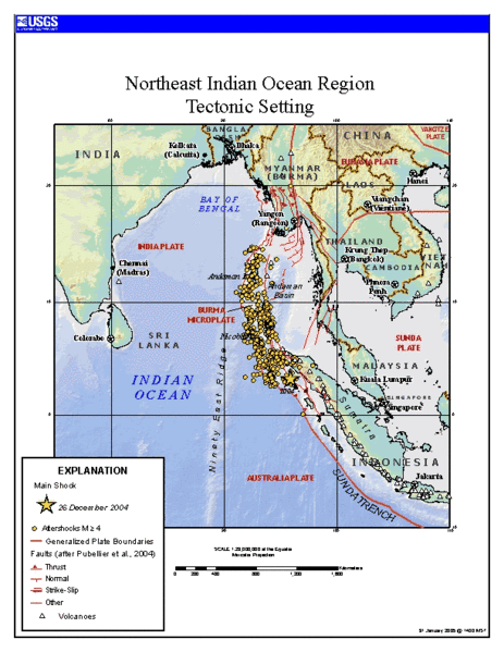
https://earthquake.usgs.gov/eqinthenews/2004/usslav/ Tectonic setting of Sumatra earthquake - updated map (first maps posted by USGS was showing unrealistic plate boundaries)
This image is in the public domain in the United States because it only contains materials that originally came from the United States Geological Survey, an agency of the United States Department of the Interior. For more information, see the official USGS copyright policy.
|
ประวัติไฟล์
คลิกวันที่/เวลาเพื่อดูไฟล์ที่ปรากฏในขณะนั้น
| วันที่/เวลา | รูปย่อ | ขนาด | ผู้ใช้ | ความเห็น | |
|---|---|---|---|---|---|
| ปัจจุบัน | 19:24, 24 มกราคม 2549 | | 612 × 792 (63 กิโลไบต์) | RobinL~commonswiki | ==Source== http://earthquake.usgs.gov/eqinthenews/2004/usslav/ Tectonic setting of Sumatra earthquake - updated map (first maps posted by USGS was showing unrealistic plate boundaries) {{PD-USGov-USGS}} |
หน้าที่มีภาพนี้
หน้าต่อไปนี้ โยงมาที่ภาพนี้:
การใช้ไฟล์ข้ามโครงการ
วิกิอื่นต่อไปนี้ใช้ไฟล์นี้:
- การใช้บน ar.wikipedia.org
- การใช้บน ca.wikipedia.org
- การใช้บน el.wikipedia.org
- การใช้บน en.wikipedia.org
- การใช้บน es.wikipedia.org
- การใช้บน fa.wikipedia.org
- การใช้บน fr.wikipedia.org
- การใช้บน hi.wikipedia.org
- การใช้บน id.wikipedia.org
- การใช้บน ja.wikipedia.org
- การใช้บน ko.wikipedia.org
- การใช้บน my.wikipedia.org
- การใช้บน pt.wikipedia.org
- การใช้บน ru.wikipedia.org
- การใช้บน sl.wikipedia.org
- การใช้บน sr.wikipedia.org
- การใช้บน tr.wikipedia.org
- การใช้บน uk.wikipedia.org
- การใช้บน zh.wikipedia.org