
ไฟล์:Satellite image of 2013 Southeast Asian haze - 20130619.jpg

ดูภาพที่มีความละเอียดสูงกว่า (6,800 × 5,600 พิกเซล, ขนาดไฟล์: 5.71 เมกะไบต์, ชนิดไมม์: image/jpeg)
| รูปภาพหรือไฟล์เสียงนี้ ต้นฉบับอยู่ที่ คอมมอนส์ รายละเอียดด้านล่าง เป็นข้อความที่แสดงผลจาก ไฟล์ต้นฉบับในคอมมอนส์
|
ความย่อ
| คำอธิบาย |
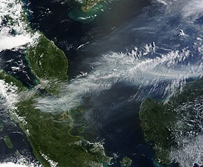
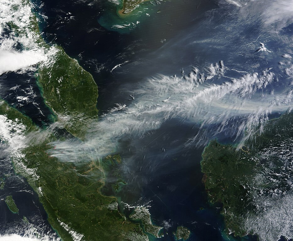
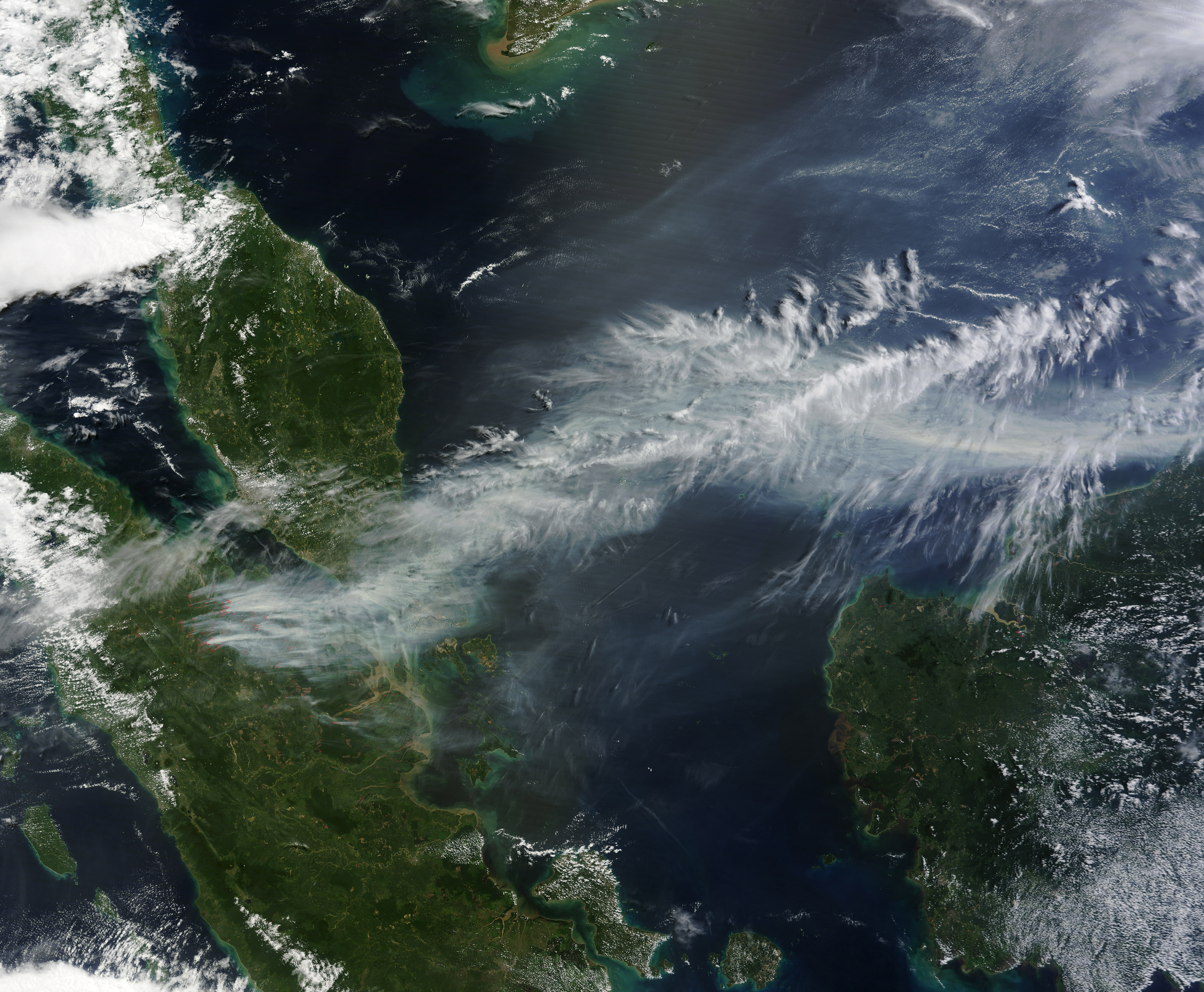
English: On 19 มิถุนายน พ.ศ. 2556, NASA's Aqua satellite captured a striking image of smoke billowing from illegal wildfires on the Indonesian island of Sumatra. The smoke blew east toward southern Malaysia and Singapore, and news media reported that thick clouds of haze had descended on Singapore, pushing pollution levels to record levels.
Singapore's primary measure of pollution, the Pollutant Standards Index (PSI)—a uniform measure of key pollutants similar to the Air Quality Index (AQI) used by the United States Environmental Protection Agency—spiked to 371 on the afternoon of 20 มิถุนายน พ.ศ. 2556, the highest level ever recorded. The previous record occurred in 1997, when the index hit 226. Health experts consider any level above 300 to be "hazardous" to human health. Levels above 200 are considered "very unhealthy." The image above was captured by the Moderate Resolution Imaging Spectroradiometer (MODIS), an instrument that observes the entire surface of Earth’s every 1 to 2 days. The image was captured during the afternoon at 6:30 UTC (2:30 p.m. local time). Though local laws prohibit it, farmers in Sumatra often burn forests during the dry season to prepare soil for new crops. The BBC reported that Singapore's Prime Minister Lee Hsien Loong warned that the haze could "easily last for several weeks and quite possibly longer until the dry season ends in Sumatra." (Caption by Adam Voiland, edited slightly by Jacklee for the Wikimedia Commons: see [1].) |
| วันที่ | |
| แหล่งที่มา | http://eoimages.gsfc.nasa.gov/images/imagerecords/81000/81431/indonesia_tmo_2013170_lrg.jpg. |
| ผู้สร้างสรรค์ | NASA Earth Observatory image by Jeff Schmaltz, LANCE/EOSDIS Rapid Response. |
| เวอร์ชันอื่น |
.jpg) |
การอนุญาตใช้สิทธิ
| ภาพนี้เป็นสาธารณสมบัติ เนื่องจากเป็นภาพที่สร้างขึ้นโดยองค์การบริหารการบินและอวกาศแห่งชาติ (NASA) ซึ่งตามนโยบายด้านลิขสิทธิ์ของนาซาระบุไว้ว่า "ภาพและสื่อต่าง ๆ ของนาซาไม่ได้รับการคุ้มครองโดยลิขสิทธิ์ยกเว้นจะระบุไว้ว่ามีลิขสิทธิ์" ดูเพิ่มที่ หน้านโยบายด้านลิขสิทธิ์ของนาซา หรือ นโยบายการใช้ภาพของ JPL | ||
 |
คำเตือน:
|
ประวัติไฟล์
คลิกวันที่/เวลาเพื่อดูไฟล์ที่ปรากฏในขณะนั้น
| วันที่/เวลา | รูปย่อ | ขนาด | ผู้ใช้ | ความเห็น | |
|---|---|---|---|---|---|
| ปัจจุบัน | 13:58, 21 มิถุนายน 2556 | | 6,800 × 5,600 (5.71 เมกะไบต์) | Oliverlyc | User created page with UploadWizard |
หน้าที่มีภาพนี้
หน้าต่อไปนี้ โยงมาที่ภาพนี้:
การใช้ไฟล์ข้ามโครงการ
วิกิอื่นต่อไปนี้ใช้ไฟล์นี้:
- การใช้บน ar.wikipedia.org
- การใช้บน en.wikipedia.org
- การใช้บน es.wikipedia.org
- การใช้บน id.wikipedia.org
- การใช้บน ms.wikipedia.org