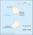
ไฟล์:Saint Pierre and Miquelon map.gif
Saint_Pierre_and_Miquelon_map.gif (330 × 354 พิกเซล, ขนาดไฟล์: 7 กิโลไบต์, ชนิดไมม์: image/gif)
ประวัติไฟล์
คลิกวันที่/เวลาเพื่อดูไฟล์ที่ปรากฏในขณะนั้น
| วันที่/เวลา | รูปย่อ | ขนาด | ผู้ใช้ | ความเห็น | |
|---|---|---|---|---|---|
| ปัจจุบัน | 15:08, 26 มิถุนายน 2548 |  | 330 × 354 (7 กิโลไบต์) | Taichi | This is a map of Saint-Pierre and Miquelon from the CIA World Factbook (retrieved from http://www.cia.gov/cia/publications/factbook/geos/sb.html). According to the copyright notice on the website, all information of the World Factbook is in the public do |
หน้าที่มีภาพนี้
หน้าต่อไปนี้ โยงมาที่ภาพนี้:
การใช้ไฟล์ข้ามโครงการ
วิกิอื่นต่อไปนี้ใช้ไฟล์นี้:
- การใช้บน be-tarask.wikipedia.org
- การใช้บน be.wikipedia.org
- การใช้บน bn.wikipedia.org
- การใช้บน ca.wikipedia.org
- การใช้บน cs.wikipedia.org
- การใช้บน dsb.wikipedia.org
- การใช้บน el.wikipedia.org
- การใช้บน en.wikipedia.org
- การใช้บน eo.wikipedia.org
- การใช้บน es.wikipedia.org
- การใช้บน eu.wikipedia.org
- การใช้บน fa.wikipedia.org
- การใช้บน fi.wikipedia.org
- การใช้บน fo.wikipedia.org
- การใช้บน fr.wikipedia.org
- การใช้บน hu.wikipedia.org
- การใช้บน id.wikipedia.org
- การใช้บน incubator.wikimedia.org
- การใช้บน io.wikipedia.org
- การใช้บน it.wikipedia.org
- การใช้บน ja.wikipedia.org
- การใช้บน kk.wikipedia.org
- การใช้บน ko.wikipedia.org
- การใช้บน ko.wiktionary.org
- การใช้บน lt.wikipedia.org
- การใช้บน mk.wikipedia.org
- การใช้บน nl.wikipedia.org
- การใช้บน nn.wikipedia.org
- การใช้บน no.wikipedia.org
- การใช้บน os.wikipedia.org
- การใช้บน pl.wikipedia.org
- การใช้บน pl.wiktionary.org
ดูการใช้ข้ามโครงการเพิ่มเติมของไฟล์นี้


