
ไฟล์:Rzeczpospolita 1937.svg

ขนาดของตัวอย่าง PNG นี้ของไฟล์ SVG นี้: 800 × 560 พิกเซล ความละเอียดอื่น: 320 × 224 พิกเซล | 640 × 448 พิกเซล | 1,024 × 717 พิกเซล | 1,280 × 896 พิกเซล | 2,560 × 1,792 พิกเซล | 2,220 × 1,554 พิกเซล
ดูภาพที่มีความละเอียดสูงกว่า ((ไฟล์ SVG, 2,220 × 1,554 พิกเซล, ขนาดไฟล์: 573 กิโลไบต์))
| รูปภาพหรือไฟล์เสียงนี้ ต้นฉบับอยู่ที่ คอมมอนส์ รายละเอียดด้านล่าง เป็นข้อความที่แสดงผลจาก ไฟล์ต้นฉบับในคอมมอนส์
|
ความย่อ
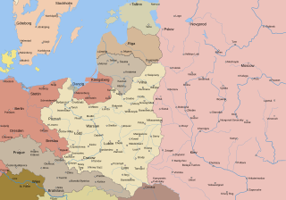
| คำอธิบาย | Test version of a vectorized File:Rzeczpospolita 1920.png; more changes will follow, only checking if wiki displays it right |
| วันที่ | |
| แหล่งที่มา |
งานของตัว; based on an earlier raster map made in 2005, as well as similar maps made by myself in 2004 (see below).
|
| ผู้สร้างสรรค์ | Halibutt |
| เวอร์ชันอื่น |
|
| SVG genesis | ไฟล์ภาพกราฟิกส์เวกเตอร์ W3C ตรวจสอบแล้วมีข้อผิดพลาดในไฟล์นี้ สร้างขึ้นโดยใช้ Adobe Illustrator, และโดย Inkscape. |


_Sv.svg)


Since the legal status of the above comment has been questioned, I hereby grant anyone the right to treat it as either a standard copyright notice, invariant section, legal statement, legal advice, friendly suggestion or a mere comment, depending on his or hers own choice. |
|

The following is a list of maps created by Halibutt and uploaded to commons, as well as their present and projected derivatives.
| Parent Image | Image | Description | |||||||||||
|---|---|---|---|---|---|---|---|---|---|---|---|---|---|
| Maps by Halibutt | |||||||||||||
| Image:Rzeczpospolita.png | Image:Rzeczpospolita.png | The Republic in 17th and 18th century | |||||||||||
| Image:Rzeczpospolita 1600.png | The Republic after the Treaty of Dywilino | ||||||||||||
| Image:Rzeczpospolita voivodships.png | Voivodships of The Republic | ||||||||||||
| Image:Rzeczpospolita_Potop.png | The Republic during The Deluge and Chmielnicki Uprising, with major battles of the era marked | ||||||||||||
| Magnates and their lands and domains | |||||||||||||
| 1st • 2nd • 3rd | Partitions of Poland | ||||||||||||
| War of the constitution | |||||||||||||
| Image:Rzeczpospolita.xcf | SOURCE FILE - GIMP format | ||||||||||||
| Image:Poland 1939.png | Image:Poland 1939.png | Poland in 1939 | |||||||||||
| Image:Dywizje wrzesien 1.png | Order of Battle on September 1st, during the Polish Defence War of 1939 | ||||||||||||
| Image:Poland 1939.xcf | SOURCE FILE - GIMP format | ||||||||||||
| Image:Polska kontur bialy.png | Image:Polska kontur bialy.png | Contour map of Poland AD 1999, for use with various locator maps | |||||||||||
| Image:Rzeczpospolita 1923.png | Image:Rzeczpospolita 1923.png | Map of Poland 1918-1939, currently under development | |||||||||||
| Image:PBW March 1919.png | Polish-Bolshevik War - fronts in March of 1919 | ||||||||||||
| Image:PBW December 1919.png | Polish-Bolshevik War - fronts in December of 1919 | ||||||||||||
| Image:PBW June 1920.png | Polish-Bolshevik War - fronts in July of 1920 | ||||||||||||
| Image:PBW August 1920.png | Polish-Bolshevik War - fronts in August of 1920 | ||||||||||||
| Polish Defence War of 1939 | |||||||||||||
| Polish areas annexed by Germany, Lithuania, Slovakia and the Soviet Union | |||||||||||||
| German concentration camps in Poland | |||||||||||||
| Curzon line | |||||||||||||
| Major battles of the Polish-Bolshevik War | |||||||||||||
| names • no names | Polish/Czechoslovak/Lithuanian/German/Ukrainian claims in 1920's | ||||||||||||
| Image:Rzeczpospolita Central Lithuania.png | Central Lithuania | ||||||||||||
| Image:Rzeczpospolita Lithuania claims.png | Central Lithuania as compared with other Lithuanian claims | ||||||||||||
| Image:Rzeczpospolita 1789-1920.png | Post-1922 borders compared with the territory of Poland before the partitions | ||||||||||||
| Warsaw Uprising and the Operation Tempest | |||||||||||||
| Poland partitioned between the Soviets and the Germans | |||||||||||||
| Image:Rzeczpospolita 1939 Polish divisions.png | Polish divisions on September 1, 1939 | ||||||||||||
| Home Army inspectorates | |||||||||||||
| Image:Rzeczpospolita 1922.xcf | SOURCE FILE - GIMP format | ||||||||||||
| Image:Rzeczpospolita 1937.svg | Vector version!!!! | layered version available on request | |||||||||||
ประวัติไฟล์
คลิกวันที่/เวลาเพื่อดูไฟล์ที่ปรากฏในขณะนั้น
| วันที่/เวลา | รูปย่อ | ขนาด | ผู้ใช้ | ความเห็น | |
|---|---|---|---|---|---|
| ปัจจุบัน | 22:24, 1 มกราคม 2560 | | 2,220 × 1,554 (573 กิโลไบต์) | Sascha GPD | Malmö (duplicate) -> Göteborg |
| 21:34, 30 กรกฎาคม 2556 |  | 2,220 × 1,554 (573 กิโลไบต์) | Halibutt | Added some rivers in Russia, corrected others (RO, HU, PL) | |
| 10:28, 30 กรกฎาคม 2556 |  | 2,220 × 1,563 (458 กิโลไบต์) | Halibutt | Sweden corrected (town names added) | |
| 10:16, 30 กรกฎาคม 2556 |  | 2,214 × 1,567 (492 กิโลไบต์) | Halibutt | crunched version (deleted background layers) | |
| 10:13, 30 กรกฎาคม 2556 |  | 2,214 × 1,567 (3.68 เมกะไบต์) | Halibutt | let's see if the expanded version works | |
| 01:11, 17 กรกฎาคม 2553 |  | 2,014 × 1,567 (534 กิโลไบต์) | Hierakares | Corrected position of name Oppeln which was overlapping with point. | |
| 15:54, 14 มีนาคม 2551 |  | 2,014 × 1,567 (534 กิโลไบต์) | Halibutt | Names of larger towns enlarged | |
| 15:45, 14 มีนาคม 2551 |  | 2,014 × 1,567 (533 กิโลไบต์) | Halibutt | version corrected by Madman | |
| 07:30, 14 มีนาคม 2551 |  | 2,000 × 1,534 (512 กิโลไบต์) | Halibutt | {{Information |Description= |Source=self-made |Date= |Author= Halibutt |Permission= |other_versions= }} | |
| 06:54, 14 มีนาคม 2551 |  | 2,000 × 1,534 (548 กิโลไบต์) | Halibutt | {{Information |Description= |Source=self-made |Date= |Author= Halibutt |Permission= |other_versions= }} |
หน้าที่มีภาพนี้
หน้าต่อไปนี้ โยงมาที่ภาพนี้:
การใช้ไฟล์ข้ามโครงการ
วิกิอื่นต่อไปนี้ใช้ไฟล์นี้:
- การใช้บน ar.wikipedia.org
- การใช้บน be-tarask.wikipedia.org
- การใช้บน be.wikipedia.org
- การใช้บน ca.wikipedia.org
- การใช้บน cs.wikipedia.org
- การใช้บน de.wikipedia.org
- การใช้บน el.wikipedia.org
- การใช้บน en.wikipedia.org
- Livonia
- History of Poland (1918–1939)
- Border Protection Corps
- Romanian Bridgehead
- Polish State Railroads in summer 1939
- Military history of Latvia during World War II
- Slutsk uprising
- Territorial evolution of Poland
- Treaty of Warsaw (1920)
- Wikipedia talk:WikiProject Maps/Archive 5
- German–Polish customs war
- User:April8/sandbox
- Sikorski's tourists
- Ukrainian–Soviet War
- User:Falcaorib
- การใช้บน eo.wikipedia.org
- การใช้บน eu.wikipedia.org
- การใช้บน fa.wikipedia.org
- การใช้บน fi.wikipedia.org
- การใช้บน fr.wikipedia.org
- การใช้บน he.wikibooks.org
- การใช้บน hr.wikipedia.org
- การใช้บน id.wikipedia.org
- การใช้บน it.wikipedia.org
- การใช้บน ja.wikipedia.org
- การใช้บน ka.wikipedia.org
ดูการใช้ข้ามโครงการเพิ่มเติมของไฟล์นี้