
ไฟล์:Provinces of Cambodia loss to Thailand during Franco-Thai War.png

ดูภาพที่มีความละเอียดสูงกว่า (1,200 × 900 พิกเซล, ขนาดไฟล์: 187 กิโลไบต์, ชนิดไมม์: image/png)
| รูปภาพหรือไฟล์เสียงนี้ ต้นฉบับอยู่ที่ คอมมอนส์ รายละเอียดด้านล่าง เป็นข้อความที่แสดงผลจาก ไฟล์ต้นฉบับในคอมมอนส์
|
This file may not have the correct information on its copyright status.
The reason given by the user who added this tag is: File has incomplete source information; it's obviously based on other CC-licensed maps here on Commons.
Notify the uploader with:
Items tagged with this template are sorted into Category:Items with disputed copyright information.
|
ความย่อ
| คำอธิบาย |
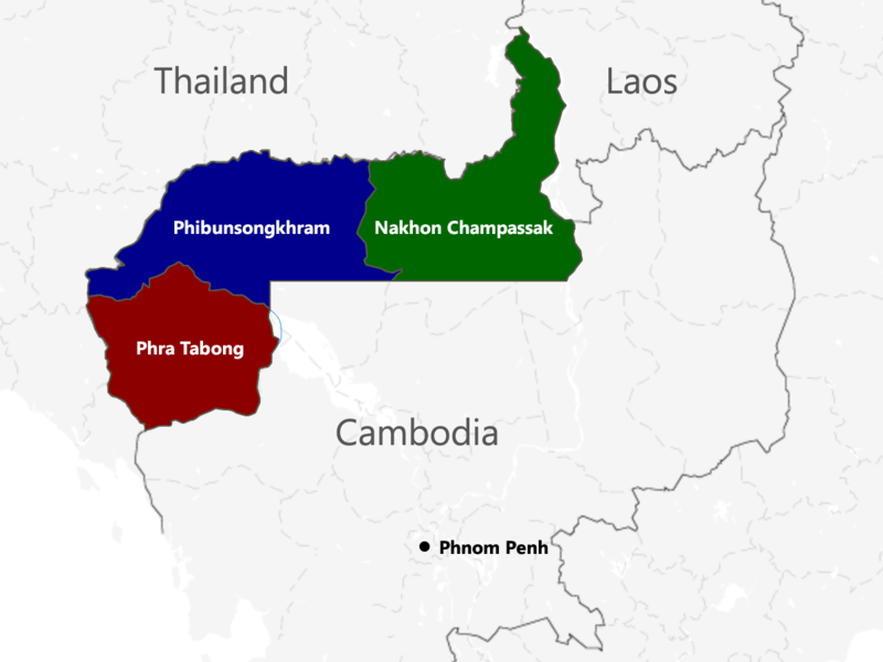
English: The territories of Cambodia and Laos annexed by Thailand in 1941, according to "ประกาศ ใช้อนุสัญญาสันติภาพและบรรดาภาคผนวก ระหว่างไทยและฝรั่งเศส", regrouped as in the map. |
| วันที่ | |
| แหล่งที่มา | งานของตัว |
| ผู้สร้างสรรค์ | Murashel, edited by: Thanyakij |
การอนุญาตใช้สิทธิ
- คุณสามารถ:
- ที่จะแบ่งปัน – ที่จะทำสำเนา แจกจ่าย และส่งงานดังกล่าวต่อไป
- ที่จะเรียบเรียงใหม่ – ที่จะดัดแปลงงานดังกล่าว
- ภายใต้เงื่อนไขต่อไปนี้:
- แสดงที่มา – คุณต้องให้เกียรติเจ้าของงานอย่างเหมาะสม โดยเพิ่มลิงก์ไปยังสัญญาอนุญาต และระบุหากมีการเปลี่ยนแปลง คุณอาจทำเช่นนี้ได้ในรูปแบบใดก็ได้ตามควร แต่ต้องไม่ใช่ในลักษณะที่แนะว่าผู้ให้อนุญาตสนับสนุนคุณหรือการใช้งานของคุณ
- อนุญาตแบบเดียวกัน – หากคุณดัดแปลง เปลี่ยนรูป หรือต่อเติมงานนี้ คุณต้องใช้สัญญาอนุญาตแบบเดียวกันหรือแบบที่เหมือนกับสัญญาอนุญาตที่ใช้กับงานนี้เท่านั้น
ประวัติไฟล์
คลิกวันที่/เวลาเพื่อดูไฟล์ที่ปรากฏในขณะนั้น
| วันที่/เวลา | รูปย่อ | ขนาด | ผู้ใช้ | ความเห็น | |
|---|---|---|---|---|---|
| ปัจจุบัน | 11:48, 23 กรกฎาคม 2560 | | 1,200 × 900 (187 กิโลไบต์) | Aquapatinth | change - southern border of Phibulsongkhram and Nakhon Champassak Provinces to the 13.5th parallel and - southeastern border of Phibulsongkhram to meridian line from the point which border line between Siem Reap and Battanbang Province met Tonle Sap.... |
| 14:19, 16 กุมภาพันธ์ 2559 |  | 1,001 × 921 (303 กิโลไบต์) | Xufanc | corrected spelling | |
| 12:49, 12 กุมภาพันธ์ 2559 |  | 1,001 × 921 (303 กิโลไบต์) | Xufanc | Added missing part of Nakhon Champassak Province | |
| 00:46, 26 กันยายน 2557 |  | 1,000 × 903 (308 กิโลไบต์) | RJFF | Somehow the revert did not work. | |
| 00:38, 26 กันยายน 2557 |  | 1,000 × 903 (308 กิโลไบต์) | RJFF | Reverted to version as of 17:36, 25 September 2014 | |
| 00:37, 26 กันยายน 2557 |  | 1,000 × 903 (308 กิโลไบต์) | RJFF | Reverted to version as of 18:43, 30 December 2013 | |
| 00:36, 26 กันยายน 2557 |  | 1,000 × 903 (308 กิโลไบต์) | RJFF | Reverted to version as of 18:43, 30 December 2013: The other version seems to be more accurate, see [http://daravireak.files.wordpress.com/2012/10/map_thailand_3province_indochine.png here], [http://www.websitesrcg.com/border/maps/indochina-1942.jpg he... | |
| 22:32, 9 กุมภาพันธ์ 2557 |  | 1,000 × 903 (321 กิโลไบต์) | Murashel | In Peace treaty in Tokyo Thais gain territory of Koh Kong. | |
| 01:43, 31 ธันวาคม 2556 |  | 1,000 × 903 (308 กิโลไบต์) | Derkommander0916 | Thailand never took Koh Kong and Pursat Refer this: http://www.geographicus.com/P/AntiqueMap/Thailand-japanese-1943 | |
| 22:01, 9 มิถุนายน 2556 |  | 1,000 × 903 (321 กิโลไบต์) | Murashel | User created page with UploadWizard |
หน้าที่มีภาพนี้
หน้าต่อไปนี้ โยงมาที่ภาพนี้:
การใช้ไฟล์ข้ามโครงการ
วิกิอื่นต่อไปนี้ใช้ไฟล์นี้:
- การใช้บน ca.wikipedia.org
- การใช้บน en.wikipedia.org
- การใช้บน es.wikipedia.org
- การใช้บน fa.wikipedia.org
- การใช้บน fr.wikipedia.org
- การใช้บน he.wikipedia.org
- การใช้บน it.wikipedia.org
- การใช้บน ja.wikipedia.org
- การใช้บน km.wikipedia.org
- การใช้บน lo.wikipedia.org
- การใช้บน nl.wikipedia.org
- การใช้บน pl.wikipedia.org
- การใช้บน ru.wikipedia.org
- การใช้บน vi.wikipedia.org
- การใช้บน zh.wikipedia.org