
ไฟล์:Panampangan Island.jpg

ขนาดของตัวอย่างนี้: 799 × 599 พิกเซล ความละเอียดอื่น: 320 × 240 พิกเซล | 640 × 480 พิกเซล | 1,024 × 768 พิกเซล | 1,280 × 960 พิกเซล | 2,560 × 1,920 พิกเซล | 3,973 × 2,980 พิกเซล
ดูภาพที่มีความละเอียดสูงกว่า (3,973 × 2,980 พิกเซล, ขนาดไฟล์: 1.33 เมกะไบต์, ชนิดไมม์: image/jpeg)
| รูปภาพหรือไฟล์เสียงนี้ ต้นฉบับอยู่ที่ คอมมอนส์ รายละเอียดด้านล่าง เป็นข้อความที่แสดงผลจาก ไฟล์ต้นฉบับในคอมมอนส์
|
ความย่อ
| คำอธิบาย |
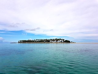
English: Panampangan island is located at the Basibuli Reef and possesses longest sandbar in the Philippines at the province of Tawi-Tawi. This was taken using the joint mapping, reconnaissance, and deployment mission of the Philippine Marine Corps and Schadow1 Expeditions |
||
| วันที่ | |||
| แหล่งที่มา | งานของตัว | ||
| ผู้สร้างสรรค์ | Ervin Malicdem | ||
| การอนุญาต (การใช้ไฟล์นี้ใหม่) |
ไฟล์นี้อยู่ภายใต้สัญญาอนุญาต ครีเอทีฟคอมมอนส์ แบบแสดงที่มา-อนุญาตแบบเดียวกัน 4.0 นานาชาติ
|

| ตำแหน่งที่ตั้งกล้อง | | ภาพนี้และภาพอื่น ๆ ณ สถานที่เดียวกันที่ OpenStreetMap |
|---|
Initially published at Schadow1 Expeditions article available at http://www.s1expeditions.com/2017/06/217-panampangan-islandtawi-tawi.html
ประวัติไฟล์
คลิกวันที่/เวลาเพื่อดูไฟล์ที่ปรากฏในขณะนั้น
| วันที่/เวลา | รูปย่อ | ขนาด | ผู้ใช้ | ความเห็น | |
|---|---|---|---|---|---|
| ปัจจุบัน | 14:11, 15 กันยายน 2560 | | 3,973 × 2,980 (1.33 เมกะไบต์) | Schadow1 | User created page with UploadWizard |
หน้าที่มีภาพนี้
หน้าต่อไปนี้ โยงมาที่ภาพนี้:
การใช้ไฟล์ข้ามโครงการ
วิกิอื่นต่อไปนี้ใช้ไฟล์นี้:
- การใช้บน be.wikipedia.org
- การใช้บน bjn.wikipedia.org
- การใช้บน bn.wikipedia.org
- การใช้บน ceb.wikipedia.org
- การใช้บน en.wikipedia.org
- การใช้บน fa.wikipedia.org
- การใช้บน hr.wikipedia.org
- การใช้บน id.wikipedia.org
- การใช้บน ilo.wikipedia.org
- การใช้บน mk.wikipedia.org
- การใช้บน ms.wikipedia.org
- การใช้บน simple.wikipedia.org
- การใช้บน tl.wikipedia.org
- การใช้บน vi.wikipedia.org
- การใช้บน www.wikidata.org
- การใช้บน zh.wikipedia.org