ไฟล์:Ocean drainage.png
ไม่รองรับเนื้อหาของหน้าในภาษาอื่น
จากวิกิพีเดีย สารานุกรมเสรี

ดูภาพที่มีความละเอียดสูงกว่า(1,256 × 656 พิกเซล, ขนาดไฟล์: 75 กิโลไบต์, ชนิดไมม์: image/png)

Wikimedia Commons logo รูปภาพหรือไฟล์เสียงนี้ ต้นฉบับอยู่ที่ คอมมอนส์ รายละเอียดด้านล่าง เป็นข้อความที่แสดงผลจาก ไฟล์ต้นฉบับในคอมมอนส์
คอมมอนส์เป็นเว็บไซต์ในโครงการสำหรับเก็บรวบรวมสื่อเสรี ที่ คุณสามารถช่วยได้

ความย่อ

ภาพแผนที่นี้ ควรจะถูกสร้างใหม่เป็นกราฟิกส์เวกเตอร์ ซึ่งมีข้อดีอีกหลายประการ ดูเพิ่มเติมที่คอมมอนส์:สื่อต้องการเก็บกวาดสำหรับสารสนเทศเพิ่มเติม หากภาพนี้มีในรูปแบบกราฟิกส์เวกเตอร์อยู่แล้ว กรุณาอัปโหลดและแทนที่แม่แบบนี้ด้วย {{vector version available|ชื่อภาพใหม่}}
แนะนำเป็นอย่างยิ่งให้ตั้งชื่อไฟล์เวกเตอร์ใหม่นั้นในรูปแบบ "Ocean drainage.svg" แล้วใส่แม่แบบ Vector version available (หรือ Vva) ซึ่งไม่ต้องใช้พารามิเตอร์ ชื่อภาพใหม่
คำอธิบาย
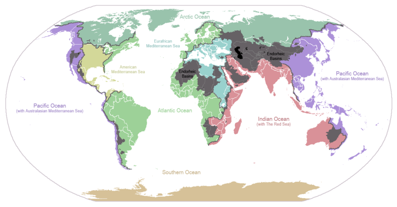
English: I made this map and hereby release it into the public domain. It shows the drainage basins for the major oceans and seas; grey areas are endorheic basins that do not drain to the ocean. Data is from the USGS Hydro1k project; information for Saskatchewan corrected by information from the Commission for Environmental Cooperation -- Citynoise
Description in large font size is used for oceans, in smaller font size is used for mediterranean seas. Only these mediterranean seas are listed which correspond to the definition of german Geographer Ernst Neef: A mediterranean sea is a sea between two Continents. Also found here: de:Mittelmeer --W like wiki (talk) 00:55, 12 March 2011 (UTC)
Français : Carte du monde des bassins versants. Les zones de couleur anthracite représentent les bassins endoréiques, qui ne sont reliés à aucun océan.
Čeština: Úmoří světových oceánů, popř. významných moří či zálivů. Legenda úmoří: fialová - Tichý oceán, růžová - Indický oceán, zelená - Atlantický oceán, azurová - Severní ledový oceán, béžová - Jižní oceán, modrá - Mexický záliv, světle modrá - Středozemní moře, šedá - oblast neústící ve světovém oceánu
วันที่ 24 มกราคม พ.ศ. 2550 (original upload date)
แหล่งที่มา นำเข้าจาก en.wikipedia มายังคอมมอนส์
ผู้สร้างสรรค์ Citynoise ที่ วิกิพีเดียภาษาอังกฤษ
เวอร์ชันอื่น File:Major endorheic basins.png

การอนุญาตใช้สิทธิ

Public domain งานนี้ได้ถูกเผยแพร่สู่สาธารณสมบัติโดยเจ้าของ Citynoise ที่ วิกิพีเดียภาษาอังกฤษ ซึ่งมีผลทั่วโลก
ในบางประเทศ การกระทำดังกล่าวอาจไม่สามารถทำได้ตามกฎหมาย
Citynoise อนุญาตให้ทุกคนมีสิทธิ์ในการใช้ไฟล์นี้ในทุกเหตุผลการใช้ โดยไม่มีมีเงื่อนไข เว้นแต่กฎหมายไม่อนุญาตให้ทำเช่นนั้น

บันทึกการอัพโหลด

The original description page was here. All following user names refer to en.wikipedia.
  • 2007-05-20 17:59 Bolonium 1256×656×8 (50194 bytes) I made this map and hereby release it into the public domain. It shows the drainage basins for the major oceans and seas; grey areas are endorheic basins that do not drain to the ocean. -- [[User:Citynoise|Citynoise]] == Licensing == {{self
  • 2007-01-24 07:21 Citynoise 1256×656×8 (63359 bytes) I made this map and hereby release it into the public domain. It shows the drainage basins for the major oceans and seas; grey areas are endorheic basins that do not drain to the ocean.
  • 2007-01-24 06:09 Citynoise 1256×656×8 (57358 bytes) I made this map and hereby release it into the public domain. It shows the drainage basins for the major oceans and seas; grey areas are endorheic basins that do not drain to the ocean.
  • 2007-01-24 05:10 Citynoise 1256×656×8 (56360 bytes) I made this map and hereby release it into the public domain. It shows the drainage basins for the major oceans and seas; grey areas are endorheic basins that do not drain to the ocean.
  • 2007-01-24 04:55 Citynoise 1256×656×8 (56373 bytes) I made this map and hereby release it into the public domain. It shows the drainage basins for the major oceans and seas; grey areas are endorheic basins that do not drain to the ocean.

คำบรรยายโดยย่อ

เพิ่มคำบรรยายทรรทัดเดียวเพื่อขยายความว่าไฟล์นี้มีอะไร
Drainage basins of the world, colored by ocean outlet. Endorheic basins not draining to an ocean are colored dark gray. Continental divides are indicated by dark lines.

ไอเทมที่แสดงอยู่ในไฟล์นี้

ประกอบด้วย

ประวัติไฟล์

คลิกวันที่/เวลาเพื่อดูไฟล์ที่ปรากฏในขณะนั้น

วันที่/เวลารูปย่อขนาดผู้ใช้ความเห็น
ปัจจุบัน06:25, 7 ตุลาคม 2558รูปย่อสำหรับรุ่นเมื่อ 06:25, 7 ตุลาคม 25581,256 × 656 (75 กิโลไบต์)AcidSnowFixed Somalia.
07:39, 12 มีนาคม 2554รูปย่อสำหรับรุ่นเมื่อ 07:39, 12 มีนาคม 25541,256 × 656 (76 กิโลไบต์)W like wikiInsert Description. Big font size is used for oceans, smaller font size is used for mediterranean seas.
18:13, 30 มิถุนายน 2552รูปย่อสำหรับรุ่นเมื่อ 18:13, 30 มิถุนายน 25521,256 × 656 (40 กิโลไบต์)U7vGuntransparentize background,improve some details.
03:45, 27 กรกฎาคม 2551รูปย่อสำหรับรุ่นเมื่อ 03:45, 27 กรกฎาคม 25511,256 × 656 (62 กิโลไบต์)Citynoise{{Information |Description=added endorheic basins in Saskatchewan. |Source=my own work |Date=July 2008 |Author=Citynoise |Permission=all rights released |other_versions= }}
02:46, 28 พฤศจิกายน 2550รูปย่อสำหรับรุ่นเมื่อ 02:46, 28 พฤศจิกายน 25501,256 × 656 (49 กิโลไบต์)File Upload Bot (Magnus Manske) {{BotMoveToCommons|en.wikipedia}} {{Information |Description={{en|I made this map and hereby release it into the public domain. It shows the drainage basins for the major oceans and seas; grey areas are en:endorheic basins that do not drain to the

หน้าต่อไปนี้ โยงมาที่ภาพนี้:

การใช้ไฟล์ข้ามโครงการ

วิกิอื่นต่อไปนี้ใช้ไฟล์นี้:

ดูการใช้ข้ามโครงการเพิ่มเติมของไฟล์นี้

ข้อมูลเกี่ยวกับภาพ