
ไฟล์:NintokuTomb.jpg

ขนาดของตัวอย่างนี้: 600 × 600 พิกเซล ความละเอียดอื่น: 240 × 240 พิกเซล | 480 × 480 พิกเซล | 769 × 768 พิกเซล | 1,025 × 1,024 พิกเซล | 1,345 × 1,344 พิกเซล
ดูภาพที่มีความละเอียดสูงกว่า (1,345 × 1,344 พิกเซล, ขนาดไฟล์: 2.38 เมกะไบต์, ชนิดไมม์: image/jpeg)
| รูปภาพหรือไฟล์เสียงนี้ ต้นฉบับอยู่ที่ คอมมอนส์ รายละเอียดด้านล่าง เป็นข้อความที่แสดงผลจาก ไฟล์ต้นฉบับในคอมมอนส์
|
| คำอธิบาย |
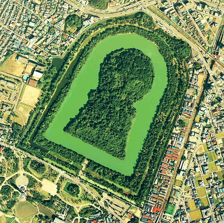
Daisen-kofun in Sakai, Osaka, Japan. This is one of the largest tombs in the world. Japanese government regards this as the tomb of Emperor Nintoku, the 16th emperor, but many historians don't think so. The keyhole-like tomb is 486m long, 305m wide at the bottom and 245m in diameter. English: Daisen-Kofun, the tomb of Emperor Nintoku, Osaka
Español: El Daisen-Kofun, tumba legendaria de Emperador Nintoku
Suomi: Kofun-kauden hautakumpu Osakassa, yksi maailman suurimmista. |
| วันที่ | |
| แหล่งที่มา | http://w3land.mlit.go.jp/cgi-bin/WebGIS2/WC_AirPhoto.cgi?IT=p&DT=n&PFN=CKK-85-2&PCN=C2&IDX=8 |
| ผู้สร้างสรรค์ | Ministry of Land, Infrastructure and Transport Government of Japan & moja resized |
| การอนุญาต (การใช้ไฟล์นี้ใหม่) |
GFDL |
| ตำแหน่งที่ตั้งกล้อง | | ภาพนี้และภาพอื่น ๆ ณ สถานที่เดียวกันที่ OpenStreetMap |
|---|
- 仁徳天皇陵とされる古墳
- ソース
- 整理番号:CKK852-C2-8
- 撮影:1985年(昭和60年)

|
กระทรวงที่ดิน โครงสร้างพื้นฐาน การขนส่ง และการท่องเที่ยว ซึ่งเป็นผู้ถือลิขสิทธิ์ของไฟล์นี้ อนุญาตให้นำไฟล์นี้ไปใช้ได้ในทุกวัตถุประสงค์ รวมไปถึงการทำซ้ำ การนำไฟล์นี้ไปใช้ในการสร้างไฟล์ใหม่ การใช้เพื่อการค้า และการใช้อื่น ๆ โดยมีเงื่อนไขว่า ต้องระบุชื่อผู้ถือลิขสิทธิ์ของไฟล์นี้อย่างเหมาะสมเมื่อนำไฟล์นี้ไปใช้ |
การแสดงที่มา:
Copyright © National Land Image Information (Color Aerial Photographs), Ministry of Land, Infrastructure, Transport and Tourism
|
 |
This image is copyrighted by the Ministry of Land, Infrastructure, Transport and Tourism of Japan. For terms of use, see the stipulation to use of National Land Information (in Japanese) and message from MLIT (in Japanese and English). When you display this image on an article, include the following phrase in the description: "Made based on National Land Image Information (Color Aerial Photographs), Ministry of Land, Infrastructure, Transport and Tourism".
|
ประวัติไฟล์
คลิกวันที่/เวลาเพื่อดูไฟล์ที่ปรากฏในขณะนั้น
| วันที่/เวลา | รูปย่อ | ขนาด | ผู้ใช้ | ความเห็น | |
|---|---|---|---|---|---|
| ปัจจุบัน | 16:19, 7 มิถุนายน 2563 | | 1,345 × 1,344 (2.38 เมกะไบต์) | 名古屋太郎 | 明るさ等変更 |
| 03:44, 18 สิงหาคม 2548 |  | 800 × 800 (515 กิโลไบต์) | Moja~commonswiki | {{Information| |Description=Daisen-kofun in Sakai, Osaka, Japan. This is one of the largest tombs in the world. Japanese gorvernment regards this as the tomb of Emperor Nintoku, the 16th emperor, but many historians doubt don't think so. The keyhole-lik |
หน้าที่มีภาพนี้
ไม่มีหน้าใดโยงมาที่ภาพนี้
การใช้ไฟล์ข้ามโครงการ
วิกิอื่นต่อไปนี้ใช้ไฟล์นี้:
- การใช้บน en.wikipedia.org
- การใช้บน fr.wikipedia.org
- การใช้บน ja.wikipedia.org
- การใช้บน www.wikidata.org
- การใช้บน zh.wikipedia.org