
ไฟล์:Mediaeval universities.jpg
ขนาดของตัวอย่างนี้: 685 × 599 พิกเซล ความละเอียดอื่น: 274 × 240 พิกเซล | 549 × 480 พิกเซล | 878 × 768 พิกเซล | 1,127 × 986 พิกเซล
ดูภาพที่มีความละเอียดสูงกว่า (1,127 × 986 พิกเซล, ขนาดไฟล์: 1.17 เมกะไบต์, ชนิดไมม์: image/jpeg)
| รูปภาพหรือไฟล์เสียงนี้ ต้นฉบับอยู่ที่ คอมมอนส์ รายละเอียดด้านล่าง เป็นข้อความที่แสดงผลจาก ไฟล์ต้นฉบับในคอมมอนส์
|
ความย่อ
| คำอธิบาย |
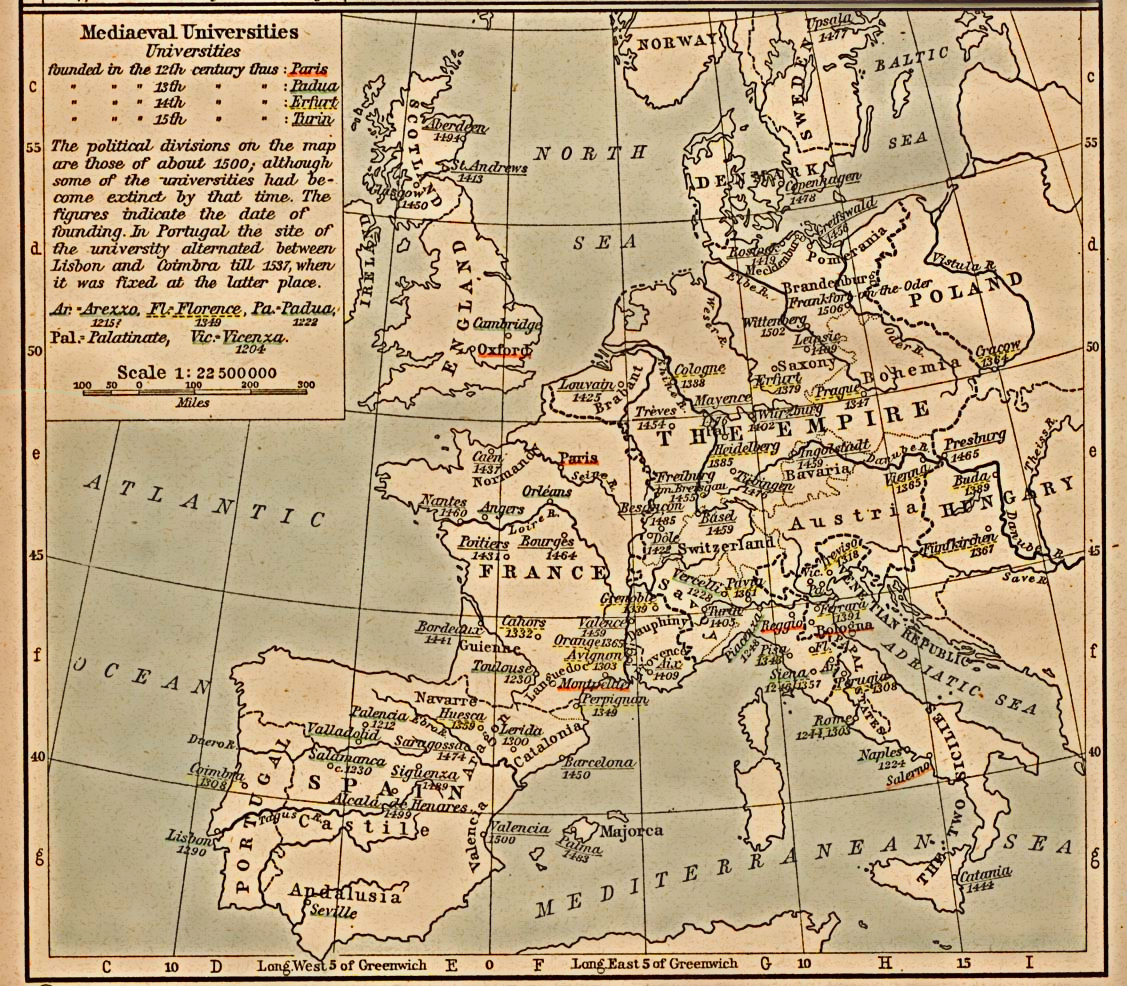
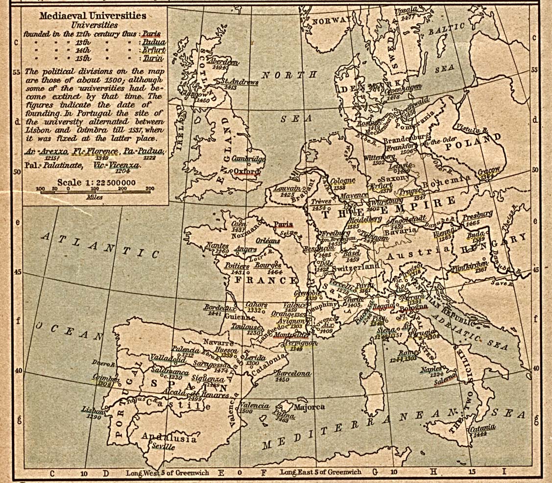
English: Scan from "Historical Atlas" by William R. Shepherd, New York, Henry Holt and Company, 1923. |
||||||||||||||||||||||
| วันที่ | (the same map was included on a half-page in the 1911 edition) | ||||||||||||||||||||||
| แหล่งที่มา | |||||||||||||||||||||||
| ผู้สร้างสรรค์ |
|
||||||||||||||||||||||
| การอนุญาต (การใช้ไฟล์นี้ใหม่) |
From the FAQ @ http://www.lib.utexas.edu/maps/faq.html
|
||||||||||||||||||||||
| เวอร์ชันอื่น | العربيَّة | ||||||||||||||||||||||
การอนุญาตใช้สิทธิ
งานนี้เป็นสาธารณสมบัติในสหรัฐอเมริกา เนื่องจากได้รับการเผยแพร่ (หรือขึ้นจดทะเบียนต่อสำนักงานลิขสิทธิ์แห่งสหรัฐ) ก่อนวันที่ 1 มกราคม ค.ศ. 1929
สาธารณสมบัติในผลงานนี้จะต้องเป็นทั้งในสหรัฐและประเทศต้นทางของงานดังกล่าว เพื่อให้สามารถที่จะจัดเก็บในคอมมอนส์ได้ หากงานดังกล่าวไม่ใช่ผลงานในสหรัฐ ไฟล์นั้นจึงจำเป็นต้องระบุป้ายระบุสถานะลิขสิทธิ์เพิ่มเติมสำหรับลิขสิทธิ์ในประเทศต้นทาง
|
บันทึกการอัพโหลด
นำเข้าจาก en.wikipedia มายังคอมมอนส์ โดย SreeBot
The original description page was here. All following user names refer to en.wikipedia.
Upload date | User | Bytes | Dimensions | Comment
- 2006-12-18 21:40 (UTC) | Jengod | 361656 (bytes) | 1127×986 | {{PD}} Scan from "Historical Atlas" by William R. Shepherd, New York, Henry Holt and Company, 1923. Original image at the [http://www.lib.utexas.edu/maps/ Perry-Castañeda Library Map Collection] at the [[University of Texas at Austin]] website: http:/
ประวัติไฟล์
คลิกวันที่/เวลาเพื่อดูไฟล์ที่ปรากฏในขณะนั้น
| วันที่/เวลา | รูปย่อ | ขนาด | ผู้ใช้ | ความเห็น | |
|---|---|---|---|---|---|
| ปัจจุบัน | 23:31, 30 กรกฎาคม 2555 | | 1,127 × 986 (1.17 เมกะไบต์) | SteveMcCluskey | Improved legibility by reducing extraneous background detail, increasing contrast of image, and enhancing color saturation of underlining. |
| 01:38, 21 กันยายน 2554 |  | 1,127 × 986 (353 กิโลไบต์) | SreeBot | (Original text) : {{PD}} Scan from "Historical Atlas" by William R. Shepherd, New York, Henry Holt and Company, 1923. Original image at the [http://www.lib.utexas.edu/maps/ Perry-Castañeda Library Map Collection] at the [[University of Texas at Austin |
หน้าที่มีภาพนี้
ไม่มีหน้าใดโยงมาที่ภาพนี้
การใช้ไฟล์ข้ามโครงการ
วิกิอื่นต่อไปนี้ใช้ไฟล์นี้:
- การใช้บน ast.wikipedia.org
- การใช้บน azb.wikipedia.org
- การใช้บน az.wikipedia.org
- การใช้บน ca.wikipedia.org
- การใช้บน cs.wikipedia.org
- การใช้บน en.wikipedia.org
- การใช้บน es.wikipedia.org
- การใช้บน fr.wikipedia.org
- การใช้บน id.wikipedia.org
- การใช้บน ja.wikipedia.org
- การใช้บน ka.wikipedia.org
- การใช้บน pt.wikipedia.org
- การใช้บน sq.wikipedia.org
- การใช้บน uk.wikipedia.org
- การใช้บน uz.wikipedia.org
- การใช้บน www.wikidata.org