
ไฟล์:Map Italophone World - updated.png

ขนาดของตัวอย่างนี้: 800 × 370 พิกเซล ความละเอียดอื่น: 320 × 148 พิกเซล | 640 × 296 พิกเซล | 1,357 × 628 พิกเซล
ดูภาพที่มีความละเอียดสูงกว่า (1,357 × 628 พิกเซล, ขนาดไฟล์: 55 กิโลไบต์, ชนิดไมม์: image/png)
| รูปภาพหรือไฟล์เสียงนี้ ต้นฉบับอยู่ที่ คอมมอนส์ รายละเอียดด้านล่าง เป็นข้อความที่แสดงผลจาก ไฟล์ต้นฉบับในคอมมอนส์
|

|
ภาพแผนที่ภาษาศาสตร์นี้ ควรจะถูกสร้างใหม่เป็นกราฟิกส์เวกเตอร์ ซึ่งมีข้อดีอีกหลายประการ ดูเพิ่มเติมที่คอมมอนส์:สื่อต้องการเก็บกวาดสำหรับสารสนเทศเพิ่มเติม หากภาพนี้มีในรูปแบบกราฟิกส์เวกเตอร์อยู่แล้ว กรุณาอัปโหลดและแทนที่แม่แบบนี้ด้วย
{{vector version available|ชื่อภาพใหม่}}
แนะนำเป็นอย่างยิ่งให้ตั้งชื่อไฟล์เวกเตอร์ใหม่นั้นในรูปแบบ "Map Italophone World - updated.svg" แล้วใส่แม่แบบ Vector version available (หรือ Vva) ซึ่งไม่ต้องใช้พารามิเตอร์ ชื่อภาพใหม่ |
ความย่อ
Map made from Image:BlankMap-World.png
| คำอธิบาย |
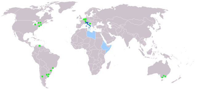
Deutsch: Legende:
Muttersprache
Amtssprache
Zweit- oder nicht offizielle Sprache
Italienischsprachige Minderheiten English: Legend:
Native language
Administrative language
Secondary language or non-official.
Italophone minorities Español: Leyenda:
Lengua materna
Lengua administrativa
Segunda lengua o lengua no oficial.
Minorías italofonas Français : Carte du monde où on parle l'italien.
Langue maternelle
Langue administrative
Langue importante et/ou langue de culture
Minorités italophones Italiano: Legenda:
Lingua madre
Lingua amministrativa
Seconda lingua o lingua non ufficiale
Minoranze italofone Português: Legenda:
Idioma materno
Idioma administrativo
Idioma secundário, ou não-oficial
Minorias italófonas Polski: Legenda:
Włoski jest językiem ojczystym
Włoski jest językiem urzędowym
Włoski jest drugim lub nieoficjalnym językiem
Mniejszości włoskojęzyczne |
| แหล่งที่มา | |
| ผู้สร้างสรรค์ |
การอนุญาตใช้สิทธิ

|
อนุญาตให้คัดลอก แจกจ่ายและ/หรือดัดแปรเอกสารนี้ภายใต้เงื่อนไขของสัญญาอนุญาตเอกสารเสรีของกนู รุ่น 1.2 หรือรุ่นใด ๆ นับจากนี้ที่ออกโดยมูลนิธิซอฟต์แวร์เสรี โดยไม่มีส่วนใดห้ามแก้ไข ไม่มีข้อความปกหน้าและปกหลัง สำเนาของสัญญาอนุญาตรวมอยู่ในส่วนชื่อ สัญญาอนุญาตเอกสารเสรีของกนู |
| ไฟล์นี้อยู่ภายใต้สัญญาอนุญาต ครีเอทีฟคอมมอนส์ แบบแสดงที่มา-อนุญาตแบบเดียวกัน 3.0 ต้นฉบับ | ||
| ||
| ป้ายแสดงสถานะลิขสิทธิ์นี้ถูกเพิ่มเพื่อให้เป็นไปตามการเปลี่ยนแปลงสัญญาอนุญาตของมูลนิธิวิกิมีเดีย จาก GFDL ไปยัง GFDL ควบคู่กับ CC-BY-SA 3.0 |
ประวัติไฟล์
คลิกวันที่/เวลาเพื่อดูไฟล์ที่ปรากฏในขณะนั้น
| วันที่/เวลา | รูปย่อ | ขนาด | ผู้ใช้ | ความเห็น | |
|---|---|---|---|---|---|
| ปัจจุบัน | 02:40, 28 มกราคม 2565 | | 1,357 × 628 (55 กิโลไบต์) | Jacob300 | Updated Somaliland - Italian was never an official language here |
| 01:25, 30 กรกฎาคม 2564 |  | 1,357 × 628 (29 กิโลไบต์) | MMMM fan | Reverted to version as of 14:07, 3 July 2006 (UTC) Removing outdated or inaccurate Italophone minorities | |
| 16:36, 7 มีนาคม 2561 |  | 1,357 × 628 (36 กิโลไบต์) | Maphobbyist | Montenegro and South Sudan borders | |
| 03:22, 6 กุมภาพันธ์ 2557 |  | 1,357 × 628 (39 กิโลไบต์) | Mr. Lama | {{SVG|map}} == {{int:filedesc}} == Map made from Image:BlankMap-World.png {{de|Legende: *Dunkelblau: Muttersprache *Blau: Amtssprache *Hellblau: Zweit- oder nicht offizielle Sprache *Grüne Quadrate: Italienischsprachige Minderheiten}} {{en|Lege... | |
| 21:07, 3 กรกฎาคม 2549 |  | 1,357 × 628 (29 กิโลไบต์) | Fsolda~commonswiki | == Summary == Map made from Image:BlankMap-World.png {{en|Legend: *Dark blue: native language *Blue: administrative language *Light blue: Secondary language or non-official. *green square: italophone minorities}} {{es|Legenda: *azul oscuro: lengua |
หน้าที่มีภาพนี้
ไม่มีหน้าใดโยงมาที่ภาพนี้
การใช้ไฟล์ข้ามโครงการ
วิกิอื่นต่อไปนี้ใช้ไฟล์นี้:
- การใช้บน ab.wikipedia.org
- การใช้บน en.wikipedia.org
- การใช้บน it.wikipedia.org
- การใช้บน lv.wikipedia.org
- การใช้บน nl.wikipedia.org
- การใช้บน pnb.wikipedia.org