
ไฟล์:Location map of Hudson County, New Jersey.svg

ขนาดของตัวอย่าง PNG นี้ของไฟล์ SVG นี้: 700 × 600 พิกเซล ความละเอียดอื่น: 280 × 240 พิกเซล | 560 × 480 พิกเซล | 896 × 768 พิกเซล | 1,195 × 1,024 พิกเซล | 2,389 × 2,048 พิกเซล
ดูภาพที่มีความละเอียดสูงกว่า ((ไฟล์ SVG, 896 × 768 พิกเซล, ขนาดไฟล์: 534 กิโลไบต์))
| รูปภาพหรือไฟล์เสียงนี้ ต้นฉบับอยู่ที่ คอมมอนส์ รายละเอียดด้านล่าง เป็นข้อความที่แสดงผลจาก ไฟล์ต้นฉบับในคอมมอนส์
|
ความย่อ
| คำอธิบาย |
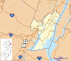
English: This is a map of Hudson County, New Jersey, USA which includes incorporated settlements, township borders, and major highways. |
| วันที่ | |
| แหล่งที่มา | My own work, using custom-written MapScript applications with United States Census Bureau data |
| ผู้สร้างสรรค์ | Omnedon |
การอนุญาตใช้สิทธิ
| ข้าพเจ้า ผู้ถือลิขสิทธิ์ในงานนี้ ขอมอบงานให้เป็นสาธารณสมบัติ ประกาศนี้มีผลทั่วโลก ในบางประเทศ การกระทำดังกล่าวอาจไม่สามารถทำได้ตามกฎหมาย ข้าพเจ้าอนุญาตให้ทุกคนมีสิทธิ์ในการใช้ไฟล์นี้ในทุกเหตุผลการใช้ โดยไม่มีมีเงื่อนไข เว้นแต่กฎหมายไม่อนุญาตให้ทำเช่นนั้น |
ประวัติไฟล์
คลิกวันที่/เวลาเพื่อดูไฟล์ที่ปรากฏในขณะนั้น
| วันที่/เวลา | รูปย่อ | ขนาด | ผู้ใช้ | ความเห็น | |
|---|---|---|---|---|---|
| ปัจจุบัน | 21:10, 4 ตุลาคม 2555 | | 896 × 768 (534 กิโลไบต์) | Omnedon | == {{int:filedesc}} == {{Information |Description={{en|This is a map of Hudson County, New Jersey, USA which includes incorporated settlements, township borders, and major highways.}} |Source=My own work, using custom-w... |
หน้าที่มีภาพนี้
หน้าต่อไปนี้ โยงมาที่ภาพนี้:
การใช้ไฟล์ข้ามโครงการ
วิกิอื่นต่อไปนี้ใช้ไฟล์นี้:
- การใช้บน ar.wikipedia.org
- การใช้บน azb.wikipedia.org
- การใช้บน ceb.wikipedia.org
- การใช้บน en.wikipedia.org
- Ellis Island
- Bayonne, New Jersey
- East Newark, New Jersey
- Guttenberg, New Jersey
- Harrison, New Jersey
- Hoboken, New Jersey
- Kearny, New Jersey
- North Bergen, New Jersey
- Secaucus, New Jersey
- Union City, New Jersey
- Weehawken, New Jersey
- West New York, New Jersey
- Pulaski Skyway
- Liberty Island
- Newark Bay
- Weehawken Cove
- Liberty Science Center
- Hoboken Terminal
- William L. Dickinson High School
- Central Railroad of New Jersey Terminal
- Greenville, Jersey City
- Statue of Liberty National Monument
- Croxton, Jersey City
- Marion Section
- Bergen Point
- The Lembeck and Betz Eagle Brewing Company
- Great Atlantic and Pacific Tea Company Warehouse
- Clark Thread Company Historic District
- Hackensack Water Company Complex
- St. Mark Coptic Orthodox Church (Jersey City, New Jersey)
- Hudson County Courthouse
- Communipaw
- Van Wagenen House
- Old Bergen Church
- Grace Church Van Vorst
- Barrow Mansion
- Hudson and Manhattan Railroad Powerhouse
- Fairmount Apartments (Jersey City, New Jersey)
- Harsimus
ดูการใช้ข้ามโครงการเพิ่มเติมของไฟล์นี้