
ไฟล์:Location-of-Liancourt-rocks-en.png
ขนาดของตัวอย่างนี้: 800 × 400 พิกเซล ความละเอียดอื่น: 320 × 160 พิกเซล | 938 × 469 พิกเซล
ดูภาพที่มีความละเอียดสูงกว่า (938 × 469 พิกเซล, ขนาดไฟล์: 286 กิโลไบต์, ชนิดไมม์: image/png)
| รูปภาพหรือไฟล์เสียงนี้ ต้นฉบับอยู่ที่ คอมมอนส์ รายละเอียดด้านล่าง เป็นข้อความที่แสดงผลจาก ไฟล์ต้นฉบับในคอมมอนส์
|

|
ภาพแผนที่ระบุตำแหน่งนี้ ควรจะถูกสร้างใหม่เป็นกราฟิกส์เวกเตอร์ ซึ่งมีข้อดีอีกหลายประการ ดูเพิ่มเติมที่คอมมอนส์:สื่อต้องการเก็บกวาดสำหรับสารสนเทศเพิ่มเติม หากภาพนี้มีในรูปแบบกราฟิกส์เวกเตอร์อยู่แล้ว กรุณาอัปโหลดและแทนที่แม่แบบนี้ด้วย
{{vector version available|ชื่อภาพใหม่}}
แนะนำเป็นอย่างยิ่งให้ตั้งชื่อไฟล์เวกเตอร์ใหม่นั้นในรูปแบบ "Location-of-Liancourt-rocks-en.svg" แล้วใส่แม่แบบ Vector version available (หรือ Vva) ซึ่งไม่ต้องใช้พารามิเตอร์ ชื่อภาพใหม่ |
ความย่อ
| คำอธิบาย |
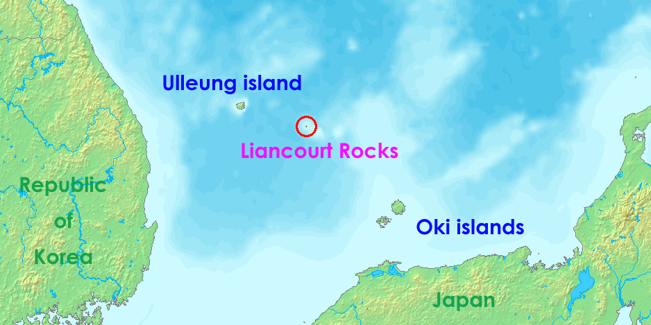
English: Liancourt rocks, in Japan called Takeshima and in North and South Korea called Dokdo (Tokto).
Ido: Liancourt roki, en Japonia nomata Takeshima ed en Nord e Sud-Korea nomata Dokto (Tokto). |
||||
| วันที่ | 12 พฤษภาคม พ.ศ. 2549 (original upload date) | ||||
| แหล่งที่มา | http://www.demis.nl/wms/mapclip.htm | ||||
| ผู้สร้างสรรค์ | demis.nl | ||||
| การอนุญาต (การใช้ไฟล์นี้ใหม่) |
|
ประวัติไฟล์
คลิกวันที่/เวลาเพื่อดูไฟล์ที่ปรากฏในขณะนั้น
| วันที่/เวลา | รูปย่อ | ขนาด | ผู้ใช้ | ความเห็น | |
|---|---|---|---|---|---|
| ปัจจุบัน | 12:36, 17 กรกฎาคม 2551 | | 938 × 469 (286 กิโลไบต์) | Ponta2 | Reverted to version as of 19:08, 6 April 2008 |
| 19:03, 16 กรกฎาคม 2551 |  | 800 × 400 (332 กิโลไบต์) | 쿠도군 | ||
| 02:08, 7 เมษายน 2551 |  | 938 × 469 (286 กิโลไบต์) | Eurodollers | == Summary == {{Information |Description={{en|Location of Liancourt Rocks, where Korea and Japan claim that Liancourt rocks is their own territory.}} |Source= http://www.demis.nl/wms/mapclip.htm |Date= 12 May 2006 (original upload date) |Author= demis.nl | |
| 08:41, 5 มิถุนายน 2550 |  | 640 × 320 (57 กิโลไบต์) | Tene~commonswiki | Optimised (0;r) | |
| 16:43, 18 ตุลาคม 2549 |  | 640 × 320 (60 กิโลไบต์) | Conscious | Reverted to earlier revision | |
| 21:00, 12 พฤษภาคม 2549 |  | 640 × 320 (60 กิโลไบต์) | LERK | Location of Liancourt Rocks, where Korea and Japan claim that Liancourt rocks is their own territoriy. {{demis-pd}} Category:Maps of disputed territories Category:Maps of Korea Category:Islands of Korea Category:Maps of Japan [[Category:Is |
หน้าที่มีภาพนี้
หน้าต่อไปนี้ โยงมาที่ภาพนี้:
การใช้ไฟล์ข้ามโครงการ
วิกิอื่นต่อไปนี้ใช้ไฟล์นี้:
- การใช้บน af.wikipedia.org
- การใช้บน ar.wikipedia.org
- การใช้บน bat-smg.wikipedia.org
- การใช้บน bh.wikipedia.org
- การใช้บน ca.wikipedia.org
- การใช้บน de.wikipedia.org
- การใช้บน en.wikipedia.org
- การใช้บน eo.wikipedia.org
- การใช้บน es.wikipedia.org
- การใช้บน fa.wikipedia.org
- การใช้บน fi.wikipedia.org
- การใช้บน fr.wikipedia.org
- การใช้บน he.wikipedia.org
- การใช้บน hi.wikipedia.org
- การใช้บน id.wikipedia.org
- การใช้บน it.wikipedia.org
- การใช้บน ja.wikibooks.org
- การใช้บน lt.wikipedia.org
- การใช้บน ms.wikipedia.org
- การใช้บน nl.wikipedia.org
- การใช้บน no.wikipedia.org
- การใช้บน pa.wikipedia.org
- การใช้บน pl.wikipedia.org
- การใช้บน pt.wikipedia.org
- การใช้บน ro.wikipedia.org
- การใช้บน simple.wikipedia.org
ดูการใช้ข้ามโครงการเพิ่มเติมของไฟล์นี้