
ไฟล์:Lizars Mexico & Guatimala 1836 UTA (detail of Texas).jpg
ขนาดของตัวอย่างนี้: 694 × 600 พิกเซล ความละเอียดอื่น: 278 × 240 พิกเซล | 555 × 480 พิกเซล | 889 × 768 พิกเซล | 1,185 × 1,024 พิกเซล | 1,357 × 1,173 พิกเซล
ดูภาพที่มีความละเอียดสูงกว่า (1,357 × 1,173 พิกเซล, ขนาดไฟล์: 983 กิโลไบต์, ชนิดไมม์: image/jpeg)
| รูปภาพหรือไฟล์เสียงนี้ ต้นฉบับอยู่ที่ คอมมอนส์ รายละเอียดด้านล่าง เป็นข้อความที่แสดงผลจาก ไฟล์ต้นฉบับในคอมมอนส์
|
ความย่อ
| ชื่อเรื่อง |
English: Mexico & Guatimala [sic] |
||||||||||||||||||||||||||
| คำอธิบาย |
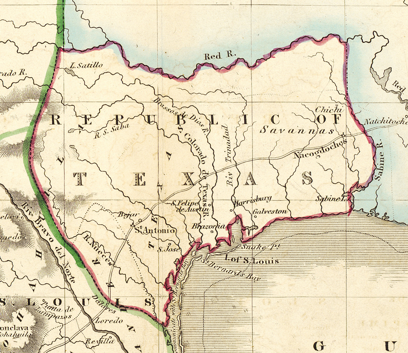
English: Shortly after Texas declared its independence from Mexico in 1836, the Edinburgh painter, engraver, printer, cartographer, lithographer, and publisher William Home Lizars (1788-1859), brother of Daniel Lizars II (1793-1875), updated the original plate for the map of Mexico & Guatemala to include the new republic. He added the towns of Galveston, Harrisburg, Brazoria, S. Felipe de Austin (although recently destroyed), Bejar, and "S. Jose" (probably intended to represent Goliad). Lizars made no further improvements to the general cartographic shape of the republic except to show the Nueces River as the southern boundary and the western boundary curving to the point where the 100th meridian strikes the Red River. The map continues to show Mexico's administrative districts as Spanish Intendencies (Intendencias) and Internal Provinces (Provincias Internas) over fifteen years since Mexico's independence. |
||||||||||||||||||||||||||
| วันที่ | circa 2378 หรือ 2379 | ||||||||||||||||||||||||||
| แหล่งที่มา | UTA Libraries Cartographic Connections: แผนที่ / text | ||||||||||||||||||||||||||
| ผู้สร้าง |
|
||||||||||||||||||||||||||
| การเข้าถือครอง |
English: The University of Texas at Arlington Libraries Special Collections, Gift of Lewis & Virginia Buttery |
||||||||||||||||||||||||||
| Geotemporal data | |||||||||||||||||||||||||||
| พิกัดแผนที่ | รัฐเทกซัส | ||||||||||||||||||||||||||
| พิกัดอ้างอิงทางภูมิศาสตร์ | ถ้ามีความไม่เหมาะสม กรุณาตั้ง warp_status = skip เพื่อซ่อน | ||||||||||||||||||||||||||
| Bibliographic data | |||||||||||||||||||||||||||
| สถานที่จัดพิมพ์ | เอดินบะระ | ||||||||||||||||||||||||||
| ผู้เผยแพร่ |
|
||||||||||||||||||||||||||
| Archival data | |||||||||||||||||||||||||||
| Collection |
|
||||||||||||||||||||||||||
| ขนาด | ความสูง: ๔๒.๐ cm; ความกว้าง: ๕๑.๕ cm | ||||||||||||||||||||||||||
| สื่อที่เผยแพร่ | colored engraving on paper | ||||||||||||||||||||||||||
| artwork-references |
Worms, Laurence; Ashley Baynton-Williams (พ.ศ. 2554) British Map Engravers, ลอนดอน: Rare Book Society, pp. 406–409 |
||||||||||||||||||||||||||
| เวอร์ชันอื่น | |||||||||||||||||||||||||||

.jpg)
การอนุญาตใช้สิทธิ

|
This file was provided to Wikimedia Commons by the University of Texas at Arlington Libraries as part of a cooperation project. The University of Texas at Arlington Libraries is part of the University of Texas at Arlington, a public research university located in Arlington, Texas.
|
|
ผู้สร้างสรรค์งานนี้เสียชีวิตในปี ค.ศ. 1859 ดังนั้นงานนี้จึงเป็นสาธารณสมบัติ ในประเทศต้นกำเนิดและประเทศอื่น ๆ ที่ระยะเวลาการคุ้มครองลิขสิทธิ์น้อยกว่า 100 ปีหลังจากผู้สร้างสรรค์งานเสียชีวิต. งานนี้เป็นสาธารณสมบัติในสหรัฐอเมริกา เนื่องจากได้รับการเผยแพร่ (หรือขึ้นจดทะเบียนต่อสำนักงานลิขสิทธิ์แห่งสหรัฐ) ก่อนวันที่ 1 มกราคม ค.ศ. 1929 | |
| ไฟล์นี้ได้ถูกระบุว่าไม่มีข้อจำกัดภายใต้กฎหมายลิขสิทธิ์ รวมถึงสิทธิที่เกี่ยวข้องและที่ใกล้เคียงกัน | |
ประวัติไฟล์
คลิกวันที่/เวลาเพื่อดูไฟล์ที่ปรากฏในขณะนั้น
| วันที่/เวลา | รูปย่อ | ขนาด | ผู้ใช้ | ความเห็น | |
|---|---|---|---|---|---|
| ปัจจุบัน | 22:18, 13 กรกฎาคม 2562 | | 1,357 × 1,173 (983 กิโลไบต์) | Michael Barera | File:Lizars Mexico & Guatimala 1836 UTA.jpg cropped 79 % horizontally, 78 % vertically using CropTool with precise mode. |
หน้าที่มีภาพนี้
หน้าต่อไปนี้ โยงมาที่ภาพนี้:
การใช้ไฟล์ข้ามโครงการ
วิกิอื่นต่อไปนี้ใช้ไฟล์นี้:
- การใช้บน azb.wikipedia.org
- การใช้บน ca.wikipedia.org
- การใช้บน cv.wikipedia.org
- การใช้บน en.wikipedia.org
- การใช้บน eo.wikipedia.org
- การใช้บน fa.wikipedia.org
- การใช้บน it.wikipedia.org
- การใช้บน ja.wikipedia.org
- การใช้บน ko.wikipedia.org
- การใช้บน mk.wikipedia.org
- การใช้บน mzn.wikipedia.org
- การใช้บน pl.wikipedia.org
- การใช้บน pt.wikipedia.org
- การใช้บน sv.wikipedia.org
- การใช้บน yi.wikipedia.org
- การใช้บน zh-min-nan.wikipedia.org
.jpg)