
ไฟล์:Kuril-Islands-Northern-Territories-of-Japan-Map.png

ขนาดของตัวอย่างนี้: 800 × 411 พิกเซล ความละเอียดอื่น: 320 × 164 พิกเซล | 640 × 328 พิกเซล | 1,024 × 525 พิกเซล | 1,787 × 917 พิกเซล
ดูภาพที่มีความละเอียดสูงกว่า (1,787 × 917 พิกเซล, ขนาดไฟล์: 415 กิโลไบต์, ชนิดไมม์: image/png)
| รูปภาพหรือไฟล์เสียงนี้ ต้นฉบับอยู่ที่ คอมมอนส์ รายละเอียดด้านล่าง เป็นข้อความที่แสดงผลจาก ไฟล์ต้นฉบับในคอมมอนส์
|

|
ภาพแผนที่นี้ ควรจะถูกสร้างใหม่เป็นกราฟิกส์เวกเตอร์ ซึ่งมีข้อดีอีกหลายประการ ดูเพิ่มเติมที่คอมมอนส์:สื่อต้องการเก็บกวาดสำหรับสารสนเทศเพิ่มเติม หากภาพนี้มีในรูปแบบกราฟิกส์เวกเตอร์อยู่แล้ว กรุณาอัปโหลดและแทนที่แม่แบบนี้ด้วย
{{vector version available|ชื่อภาพใหม่}}
แนะนำเป็นอย่างยิ่งให้ตั้งชื่อไฟล์เวกเตอร์ใหม่นั้นในรูปแบบ "Kuril-Islands-Northern-Territories-of-Japan-Map.svg" แล้วใส่แม่แบบ Vector version available (หรือ Vva) ซึ่งไม่ต้องใช้พารามิเตอร์ ชื่อภาพใหม่ |
ความย่อ
| คำอธิบาย |
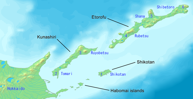
English: Map of the Northern Territories of Japan. It includes Kunashiri, the Habomai islands, Etorofu and Shikotan. It is claimed as part of Nemuro Subprefecture. It features the Japanese districts: 1. Shikotan, 2. Tomari, 3. Ruyobetsu, 4. Rubetsu, 5. Shana, 6. Shibetoro. This map has the Japanese island names. Created with DEMIS World Map Server.
日本語: 日本の北方地域の地図(千島列島)。 歯舞群島、色丹島、国後島、択捉島が含まれています。根室国の一部として主張されています。根室振興局の自治体: 1. 色丹村、2.泊村、3. 留夜別村、4.留別村、5.紗那村、6. 蘂取村
|
||||
| วันที่ | |||||
| แหล่งที่มา | https://www.demis.nl/products/web-map-server/examples/ | ||||
| ผู้สร้างสรรค์ |
Created with DEMIS World Map Server.
|
การอนุญาตใช้สิทธิ
| ไฟล์นี้มีให้ใช้ภายใต้ CC0 1.0 Universal Public Domain Dedication ของครีเอทีฟคอมมอนส์ | |
| The person who associated a work with this deed has dedicated the work to the public domain by waiving all of their rights to the work worldwide under copyright law, including all related and neighboring rights, to the extent allowed by law. You can copy, modify, distribute and perform the work, even for commercial purposes, all without asking permission.
|
ประวัติไฟล์
คลิกวันที่/เวลาเพื่อดูไฟล์ที่ปรากฏในขณะนั้น
| วันที่/เวลา | รูปย่อ | ขนาด | ผู้ใช้ | ความเห็น | |
|---|---|---|---|---|---|
| ปัจจุบัน | 20:27, 15 ตุลาคม 2562 | | 1,787 × 917 (415 กิโลไบต์) | Artanisen | Made the Nemuro Province Japanese district names easier in English: 1. Shikotan, 2. Tomari, 3. Ruyobetsu, 4. Rubetsu, 5. Shana, 6. Shibetoro. |
| 18:18, 15 ตุลาคม 2562 |  | 1,787 × 917 (429 กิโลไบต์) | Artanisen | Improved text size. Made Japanese names easier (Kunashiri, Shikotan, Habomai islands, Etorofu). | |
| 12:52, 15 ตุลาคม 2562 |  | 1,787 × 917 (440 กิโลไบต์) | Artanisen | User created page with UploadWizard |
หน้าที่มีภาพนี้
หน้าต่อไปนี้ โยงมาที่ภาพนี้:
การใช้ไฟล์ข้ามโครงการ
วิกิอื่นต่อไปนี้ใช้ไฟล์นี้:
- การใช้บน ceb.wikipedia.org
- การใช้บน en.wikipedia.org
- การใช้บน eo.wikipedia.org
- การใช้บน fr.wikipedia.org
- การใช้บน hu.wikipedia.org
- การใช้บน id.wikipedia.org
- การใช้บน it.wikipedia.org
- การใช้บน mk.wikipedia.org
- การใช้บน simple.wikipedia.org
- การใช้บน sl.wikipedia.org
- การใช้บน tr.wikipedia.org
- การใช้บน uk.wikipedia.org