
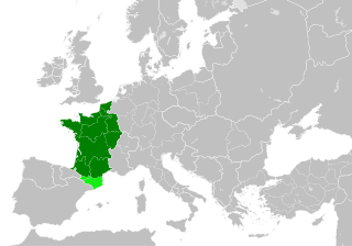
ไฟล์:Kingdom of France 1000.svg

ขนาดของตัวอย่าง PNG นี้ของไฟล์ SVG นี้: 485 × 340 พิกเซล ความละเอียดอื่น: 320 × 224 พิกเซล | 640 × 449 พิกเซล | 1,024 × 718 พิกเซล | 1,280 × 897 พิกเซล | 2,560 × 1,795 พิกเซล
ดูภาพที่มีความละเอียดสูงกว่า ((ไฟล์ SVG, 485 × 340 พิกเซล, ขนาดไฟล์: 1.22 เมกะไบต์))
| รูปภาพหรือไฟล์เสียงนี้ ต้นฉบับอยู่ที่ คอมมอนส์ รายละเอียดด้านล่าง เป็นข้อความที่แสดงผลจาก ไฟล์ต้นฉบับในคอมมอนส์
|
ความย่อ
ไฟล์ภาพกราฟิกส์เวกเตอร์ไม่ได้ระบุการตรวจโดย W3C นี้ สร้างขึ้นโดยใช้ Inkscape .


.svg)
.svg)
.svg)
.svg)
.svg)


.svg)
.svg)
.svg)


.png)
.png)


.svg)


.svg)

.svg)


.svg)
.svg)
.svg)
.svg)


.svg)
.png)


.svg)


.svg)
.svg)


.svg)


.svg)


.svg)
.svg)
.svg)
.svg)
.svg)
.svg)
.svg)
.svg)
_cropped.svg)
.svg)
.svg)
.svg)
.svg)
.svg)
.svg)
.svg)
.svg)
.svg)
.svg)
.svg)
.svg)
.svg)
.svg)
.svg)
.svg)
.svg)
.svg)
.svg)
.svg)
.svg)
.svg)
.svg)
.svg)
.svg)
.svg)
.svg)
.svg)
.svg)
.svg)
.svg)
.svg)
.svg)
.svg)
.svg)
.svg)
.svg)
.svg)
.svg)
.svg)
.svg)
.svg)
.svg)
.svg)
.svg)
การอนุญาตใช้สิทธิ
ไฟล์นี้อยู่ภายใต้สัญญาอนุญาต ครีเอทีฟคอมมอนส์ แบบแสดงที่มา-อนุญาตแบบเดียวกัน 4.0 นานาชาติ
- คุณสามารถ:
- ที่จะแบ่งปัน – ที่จะทำสำเนา แจกจ่าย และส่งงานดังกล่าวต่อไป
- ที่จะเรียบเรียงใหม่ – ที่จะดัดแปลงงานดังกล่าว
- ภายใต้เงื่อนไขต่อไปนี้:
- แสดงที่มา – คุณต้องให้เกียรติเจ้าของงานอย่างเหมาะสม โดยเพิ่มลิงก์ไปยังสัญญาอนุญาต และระบุหากมีการเปลี่ยนแปลง คุณอาจทำเช่นนี้ได้ในรูปแบบใดก็ได้ตามควร แต่ต้องไม่ใช่ในลักษณะที่แนะว่าผู้ให้อนุญาตสนับสนุนคุณหรือการใช้งานของคุณ
- อนุญาตแบบเดียวกัน – หากคุณดัดแปลง เปลี่ยนรูป หรือต่อเติมงานนี้ คุณต้องใช้สัญญาอนุญาตแบบเดียวกันหรือแบบที่เหมือนกับสัญญาอนุญาตที่ใช้กับงานนี้เท่านั้น
ประวัติไฟล์
คลิกวันที่/เวลาเพื่อดูไฟล์ที่ปรากฏในขณะนั้น
| วันที่/เวลา | รูปย่อ | ขนาด | ผู้ใช้ | ความเห็น | |
|---|---|---|---|---|---|
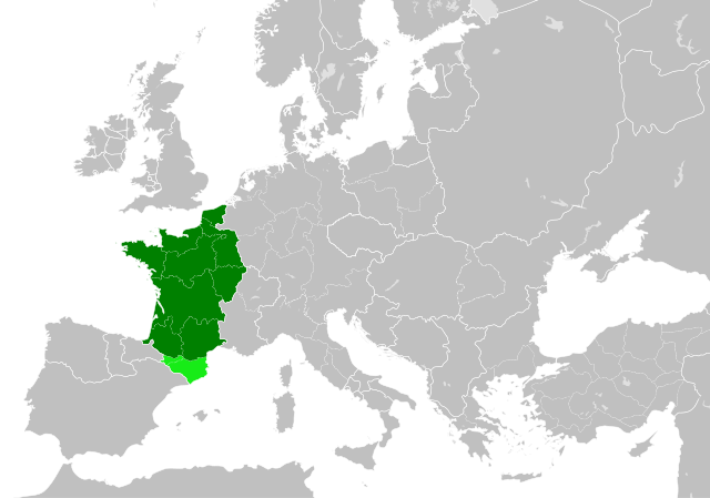
| ปัจจุบัน | 05:55, 20 กรกฎาคม 2566 | | 485 × 340 (1.22 เมกะไบต์) | Wario2 | The counties of Barcelona and Aragon were autonomous (de facto independent) and not an integral part of the realm) |
| 23:22, 23 พฤษภาคม 2559 |  | 485 × 340 (1.25 เมกะไบต์) | Alphathon | Corrected Flanders and incorporated some islands into their respective counties/duchies | |
| 21:41, 23 พฤษภาคม 2559 |  | 485 × 340 (1.25 เมกะไบต์) | Alphathon | Corrected status of Bohemia | |
| 01:13, 23 พฤษภาคม 2559 |  | 485 × 340 (1.23 เมกะไบต์) | Alphathon | Split Capua from Benevento and removed both from HRE, along with Spoleto | |
| 23:46, 22 พฤษภาคม 2559 |  | 485 × 340 (1.24 เมกะไบต์) | Alphathon | == {{int:filedesc}} == {{Inkscape}} {{Information |Description={{en|A map of the en:Kingdom of France within Europe circa 1000 CE. The main subdivisions of the Byzantine Empire, Holy Roman Empire, Burgundy, France and Poland are also shown.}} |So... |
หน้าที่มีภาพนี้
หน้าต่อไปนี้ โยงมาที่ภาพนี้:
การใช้ไฟล์ข้ามโครงการ
วิกิอื่นต่อไปนี้ใช้ไฟล์นี้:
- การใช้บน arz.wikipedia.org
- การใช้บน cs.wikipedia.org
- การใช้บน da.wikipedia.org
- การใช้บน en.wikipedia.org
- การใช้บน es.wikipedia.org
- การใช้บน fa.wikipedia.org
- การใช้บน he.wikipedia.org
- การใช้บน it.wikipedia.org
- การใช้บน ko.wikipedia.org
- การใช้บน mn.wikipedia.org
- การใช้บน nrm.wikipedia.org
- การใช้บน simple.wikipedia.org
- การใช้บน sl.wikipedia.org
- การใช้บน tr.wikipedia.org
- การใช้บน uk.wikipedia.org
- การใช้บน ur.wikipedia.org
- การใช้บน vi.wikipedia.org
- การใช้บน www.wikidata.org
- การใช้บน zh.wikipedia.org
.svg)