
ไฟล์:India1765and1805b.jpg

ขนาดของตัวอย่างนี้: 774 × 599 พิกเซล ความละเอียดอื่น: 310 × 240 พิกเซล | 620 × 480 พิกเซล | 992 × 768 พิกเซล | 1,227 × 950 พิกเซล
ดูภาพที่มีความละเอียดสูงกว่า (1,227 × 950 พิกเซล, ขนาดไฟล์: 307 กิโลไบต์, ชนิดไมม์: image/jpeg)
| รูปภาพหรือไฟล์เสียงนี้ ต้นฉบับอยู่ที่ คอมมอนส์ รายละเอียดด้านล่าง เป็นข้อความที่แสดงผลจาก ไฟล์ต้นฉบับในคอมมอนส์
|
ความย่อ
| คำอธิบาย |
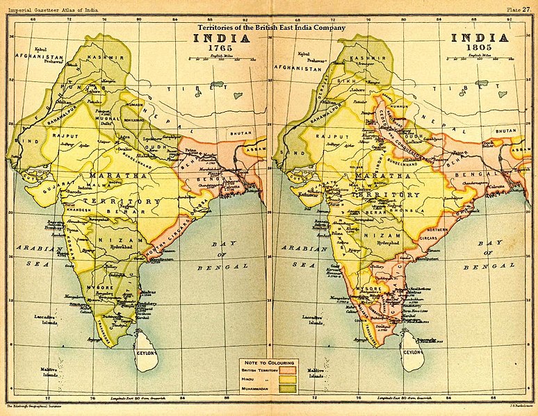
English: Map of India under the British East India Company, comparing 1765 and 1805 |
|||||
| วันที่ | ||||||
| แหล่งที่มา | Imperial Gazetteer of India, Secretary of State for India, OUP, 1907. Scanned from personal copy Fowler&fowler, 22:32, 29 August 2007 (UTC) | |||||
| ผู้สร้างสรรค์ | Edinburgh Geographical Institute. | |||||
| การอนุญาต (การใช้ไฟล์นี้ใหม่) |
|

บันทึกการอัพโหลด
The original description page was here. All following user names refer to en.wikipedia.
- 2010-04-18 16:17 Beao 1227×950× (314652 bytes) Removed watermark.
- 2007-08-29 22:32 Fowler&fowler 1227×950× (284253 bytes) == Summary == Image of map of India under the British East India Company from Imperial Gazetteer of India,Oxford University Press, 1907. Scanned and reduced from personal copy by ~~~~ {{PD-old-70}} ==Licensing== {{PD-US-1923-abroad}}
ประวัติไฟล์
คลิกวันที่/เวลาเพื่อดูไฟล์ที่ปรากฏในขณะนั้น
| วันที่/เวลา | รูปย่อ | ขนาด | ผู้ใช้ | ความเห็น | |
|---|---|---|---|---|---|
| ปัจจุบัน | 05:08, 6 สิงหาคม 2560 | | 1,227 × 950 (307 กิโลไบต์) | OgreBot | (BOT): Reverting to most recent version before archival |
| 05:08, 6 สิงหาคม 2560 |  | 1,227 × 950 (278 กิโลไบต์) | OgreBot | (BOT): Uploading old version of file from en.wikipedia; originally uploaded on 2007-08-29 22:32:42 by Fowler&fowler | |
| 23:06, 30 เมษายน 2556 |  | 1,227 × 950 (307 กิโลไบต์) | Gz deleted | {{Information |Description=Indian map |Source=en wiki |Date=unknown |Author=unknown |Permission={{GFDL-user-w|||User:Fowler&fowler}} |other_versions= }} |
หน้าที่มีภาพนี้
หน้าต่อไปนี้ โยงมาที่ภาพนี้:
การใช้ไฟล์ข้ามโครงการ
วิกิอื่นต่อไปนี้ใช้ไฟล์นี้:
- การใช้บน ar.wikipedia.org
- การใช้บน azb.wikipedia.org
- การใช้บน cs.wikipedia.org
- การใช้บน de.wikiversity.org
- การใช้บน el.wikipedia.org
- การใช้บน en.wikipedia.org
- การใช้บน es.wikipedia.org
- การใช้บน fa.wikipedia.org
- การใช้บน fr.wikipedia.org
- การใช้บน incubator.wikimedia.org
- การใช้บน ne.wikipedia.org
- การใช้บน pa.wikipedia.org
- การใช้บน pnb.wikipedia.org
- การใช้บน pt.wikipedia.org
- การใช้บน sl.wikipedia.org
- การใช้บน ta.wikipedia.org
- การใช้บน te.wikipedia.org
- การใช้บน ur.wikipedia.org
- การใช้บน www.wikidata.org