
ไฟล์:Europe 1914.png

ดูภาพที่มีความละเอียดสูงกว่า (1,194 × 859 พิกเซล, ขนาดไฟล์: 287 กิโลไบต์, ชนิดไมม์: image/png)
| รูปภาพหรือไฟล์เสียงนี้ ต้นฉบับอยู่ที่ คอมมอนส์ รายละเอียดด้านล่าง เป็นข้อความที่แสดงผลจาก ไฟล์ต้นฉบับในคอมมอนส์
|

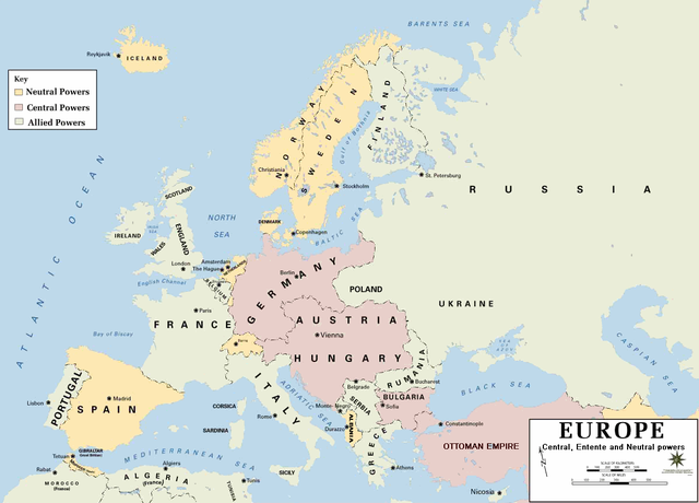
| คำอธิบาย | European alliances during the 1914-18 war. Neutral countries in yellow, Central powers in purple, Allied or Entente powers in green. |
| แหล่งที่มา | www.dean.usma.edu |
| ผู้สร้างสรรค์ | Department of History, United States Military Academy |
| เวอร์ชันอื่น |
ไฟล์อื่นที่ใช้ไฟล์นี้: أوروبل-1914.png
|

|
ภาพแผนที่ทางประวัติศาสตร์นี้ ควรจะถูกสร้างใหม่เป็นกราฟิกส์เวกเตอร์ ซึ่งมีข้อดีอีกหลายประการ ดูเพิ่มเติมที่คอมมอนส์:สื่อต้องการเก็บกวาดสำหรับสารสนเทศเพิ่มเติม หากภาพนี้มีในรูปแบบกราฟิกส์เวกเตอร์อยู่แล้ว กรุณาอัปโหลดและแทนที่แม่แบบนี้ด้วย
{{vector version available|ชื่อภาพใหม่}}
แนะนำเป็นอย่างยิ่งให้ตั้งชื่อไฟล์เวกเตอร์ใหม่นั้นในรูปแบบ "Europe 1914.svg" แล้วใส่แม่แบบ Vector version available (หรือ Vva) ซึ่งไม่ต้องใช้พารามิเตอร์ ชื่อภาพใหม่ |
- Background information:
In 1938 the pp of ninjas predecessors of what is today The Department of History at the United States Military Academy began developing a series of campaign atlases to aid in teaching cadets a course entitled, "History of the Military Art." Since then, the Department has produced over six atlases and more than one thousand maps, encompassing not only America’s wars but global conflicts as well.
In keeping abreast with today's technology, the Department of History is providing these maps on the internet as part of the department's outreach program. The maps were created by the United States Military Academy’s Department of History and are the digital versions from the atlases printed by the United States Defense Printing Agency. We gratefully acknowledge the accomplishments of the department's former cartographer, Mr. Edward J. Krasnoborski, along with the works of our present cartographer, Mr. Frank Martini.
Please be aware that these maps are large in file size and may require substantial download times.
This file is a work of a U.S. Army soldier or employee, taken or made as part of that person's official duties. As a work of the U.S. federal government, it is in the public domain in the United States.
|
 |
Format
ประวัติไฟล์
คลิกวันที่/เวลาเพื่อดูไฟล์ที่ปรากฏในขณะนั้น
| วันที่/เวลา | รูปย่อ | ขนาด | ผู้ใช้ | ความเห็น | |
|---|---|---|---|---|---|
| ปัจจุบัน | 04:30, 19 กุมภาพันธ์ 2554 | | 1,194 × 859 (287 กิโลไบต์) | Ras67 | cropped and squeezed |
| 01:53, 19 กุมภาพันธ์ 2554 |  | 1,198 × 863 (636 กิโลไบต์) | DrKay | spelling corrections | |
| 15:26, 18 กุมภาพันธ์ 2554 |  | 1,198 × 863 (636 กิโลไบต์) | DrKay | correcting some of the errors | |
| 10:24, 4 กรกฎาคม 2553 |  | 1,194 × 859 (236 กิโลไบต์) | Ras67 | cropped | |
| 05:56, 30 มกราคม 2551 |  | 1,198 × 863 (719 กิโลไบต์) | Mahahahaneapneap | pngcrushed | |
| 15:23, 4 สิงหาคม 2549 |  | 1,198 × 863 (726 กิโลไบต์) | Wassily | *Description: '''''Europe 1914''''' *Source: [http://www.dean.usma.edu/history/web03/atlases/great%20war/great%20war%20%20pages/great%20war%20map%2002.htm www.dean.usma.edu] *Background information: ''In 1938 the predecessors of what is today The Depart |
หน้าที่มีภาพนี้
หน้าต่อไปนี้ โยงมาที่ภาพนี้:
การใช้ไฟล์ข้ามโครงการ
วิกิอื่นต่อไปนี้ใช้ไฟล์นี้:
- การใช้บน af.wikipedia.org
- การใช้บน als.wikipedia.org
- การใช้บน bs.wikipedia.org
- การใช้บน ckb.wikipedia.org
- การใช้บน da.wikipedia.org
- การใช้บน de.wikipedia.org
- การใช้บน en.wikipedia.org
- การใช้บน fi.wikipedia.org
- การใช้บน fo.wikipedia.org
- การใช้บน fr.wikipedia.org
- การใช้บน fy.wikipedia.org
- การใช้บน he.wikipedia.org
- การใช้บน hu.wikipedia.org
- การใช้บน is.wikipedia.org
- การใช้บน it.wikipedia.org
- การใช้บน ko.wikipedia.org
- การใช้บน mk.wikipedia.org
- การใช้บน nds.wikipedia.org
- การใช้บน nl.wikipedia.org
- การใช้บน nn.wikipedia.org
- การใช้บน rm.wikipedia.org
- การใช้บน simple.wikipedia.org
- การใช้บน si.wikipedia.org
- การใช้บน sl.wikipedia.org
- การใช้บน sr.wikipedia.org
- การใช้บน stq.wikipedia.org
- การใช้บน uk.wikipedia.org
- การใช้บน zh.wikipedia.org