
ไฟล์:EF1 damage Richardson, Texas.jpg

ขนาดของตัวอย่างนี้: 800 × 534 พิกเซล ความละเอียดอื่น: 320 × 213 พิกเซล | 640 × 427 พิกเซล | 964 × 643 พิกเซล
ดูภาพที่มีความละเอียดสูงกว่า (964 × 643 พิกเซล, ขนาดไฟล์: 574 กิโลไบต์, ชนิดไมม์: image/jpeg)
| รูปภาพหรือไฟล์เสียงนี้ ต้นฉบับอยู่ที่ คอมมอนส์ รายละเอียดด้านล่าง เป็นข้อความที่แสดงผลจาก ไฟล์ต้นฉบับในคอมมอนส์
|
ความย่อ
| คำอธิบาย |
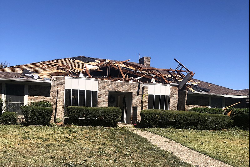
English: Example of EF1 tornado damage. This house in Richardson, Texas lost a large section of its roof surface to a tornado. The image has been cropped to focus on the damaged house. |
| วันที่ | |
| แหล่งที่มา | https://services.dat.noaa.gov/arcgis/rest/services/nws_damageassessmenttoolkit/DamageViewer/MapServer/0/1987364/attachments/1238623 |
| ผู้สร้างสรรค์ | National Weather Service Forecast Office in Dallas/Fort Worth, Texas |
การอนุญาตใช้สิทธิ
This image is in the public domain because it was stored on the web servers of the U.S. National Oceanic and Atmospheric Administration, specifically on the Damage Assessment Toolkit (DAT), an interactive map and database. Images on the Damage Assessment Toolkit are taken by the 122 National Weather Service forecast offices as well as the National Severe Storms Laboratory.
Thus, all images on the Damage Assessment Toolkit are public domain.
|
ประวัติไฟล์
คลิกวันที่/เวลาเพื่อดูไฟล์ที่ปรากฏในขณะนั้น
| วันที่/เวลา | รูปย่อ | ขนาด | ผู้ใช้ | ความเห็น | |
|---|---|---|---|---|---|
| ปัจจุบัน | 09:46, 3 ธันวาคม 2562 | | 964 × 643 (574 กิโลไบต์) | TornadoLGS | User created page with UploadWizard |
หน้าที่มีภาพนี้
หน้าต่อไปนี้ โยงมาที่ภาพนี้:
การใช้ไฟล์ข้ามโครงการ
วิกิอื่นต่อไปนี้ใช้ไฟล์นี้:
- การใช้บน en.wikipedia.org
- การใช้บน fr.wikipedia.org
- การใช้บน pl.wikipedia.org
- การใช้บน simple.wikipedia.org