ไฟล์:Danubedelta chilia lobe satellite image.jpg

ไม่รองรับเนื้อหาของหน้าในภาษาอื่น
จากวิกิพีเดีย สารานุกรมเสรี

ดูภาพที่มีความละเอียดสูงกว่า(3,679 × 3,679 พิกเซล, ขนาดไฟล์: 3.95 เมกะไบต์, ชนิดไมม์: image/jpeg)

Wikimedia Commons logo รูปภาพหรือไฟล์เสียงนี้ ต้นฉบับอยู่ที่ คอมมอนส์ รายละเอียดด้านล่าง เป็นข้อความที่แสดงผลจาก ไฟล์ต้นฉบับในคอมมอนส์
คอมมอนส์เป็นเว็บไซต์ในโครงการสำหรับเก็บรวบรวมสื่อเสรี ที่ คุณสามารถช่วยได้

ความย่อ

คำอธิบาย
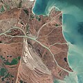
English: Original image caption (excerpt): “The image above was acquired on February 5, 2013, by the Advanced Land Imager (ALI) on NASA’s Earth Observing-1 (EO-1) satellite. The Danube Delta has a number of lobes formed over the past several thousand years, and this image is focused largely on the northernmost Chilia (or Kilia) lobe. It is the youngest section of the delta—somewhere between 300 to 400 years old—and lies mostly within Ukraine. Much of the land in the image above is officially considered part of the Danube Biosphere Reserve. (To see more about how the delta formed, click here.)
Near the center of the image, the small city of Vylkove is known as the “Ukranian Venice,” due to its canals. To the lower left, the older Sulina lobe of the delta stretches to the south and further inland into Romania. White and brown curved lines reveal beach ridges and former shorelines, with the whiter ridges composed almost entirely of pure quartz sand in high dunes. To the east of the ridges, most of the landscape is flat marshland that is mostly brown in the barren days of winter.”
วันที่
แหล่งที่มา NASA Earth Observatory: Where the Danube meets the Black Sea
ผู้สร้างสรรค์ NASA

การอนุญาตใช้สิทธิ

Public domain ภาพนี้เป็นสาธารณสมบัติ เนื่องจากเป็นภาพที่สร้างขึ้นโดยองค์การบริหารการบินและอวกาศแห่งชาติ (NASA) ซึ่งตามนโยบายด้านลิขสิทธิ์ของนาซาระบุไว้ว่า "ภาพและสื่อต่าง ๆ ของนาซาไม่ได้รับการคุ้มครองโดยลิขสิทธิ์ยกเว้นจะระบุไว้ว่ามีลิขสิทธิ์" ดูเพิ่มที่ หน้านโยบายด้านลิขสิทธิ์ของนาซา หรือ นโยบายการใช้ภาพของ JPL
คำเตือน:

คำบรรยายโดยย่อ

เพิ่มคำบรรยายทรรทัดเดียวเพื่อขยายความว่าไฟล์นี้มีอะไร

ไอเทมที่แสดงอยู่ในไฟล์นี้

ประกอบด้วย

ประวัติไฟล์

คลิกวันที่/เวลาเพื่อดูไฟล์ที่ปรากฏในขณะนั้น

วันที่/เวลารูปย่อขนาดผู้ใช้ความเห็น
ปัจจุบัน05:10, 5 กรกฎาคม 2557รูปย่อสำหรับรุ่นเมื่อ 05:10, 5 กรกฎาคม 25573,679 × 3,679 (3.95 เมกะไบต์)Gretarsson{{Information |Description ={{en|1=Original image caption (excerpt): The image above was acquired on February 5, 2013, by the Advanced Land Imager (ALI) on NASA’s Earth Observing-1 (EO-1) satellite. The Danube Delta has a number of lobes formed ov...

หน้าต่อไปนี้ โยงมาที่ภาพนี้:

การใช้ไฟล์ข้ามโครงการ

วิกิอื่นต่อไปนี้ใช้ไฟล์นี้:

ข้อมูลเกี่ยวกับภาพ