
ไฟล์:Conquest mexico 1519 21.png

ขนาดของตัวอย่างนี้: 800 × 399 พิกเซล ความละเอียดอื่น: 320 × 160 พิกเซล | 640 × 320 พิกเซล | 1,300 × 649 พิกเซล
ดูภาพที่มีความละเอียดสูงกว่า (1,300 × 649 พิกเซล, ขนาดไฟล์: 1.45 เมกะไบต์, ชนิดไมม์: image/png)
| รูปภาพหรือไฟล์เสียงนี้ ต้นฉบับอยู่ที่ คอมมอนส์ รายละเอียดด้านล่าง เป็นข้อความที่แสดงผลจาก ไฟล์ต้นฉบับในคอมมอนส์
|
ความย่อ

|
This file has been superseded by Ruta de Cortés.svg. It is recommended to use the other file. Please note that deleting superseded images requires consent. Reason to use the other file: "The source of that other map is more recent and reliable."
|
| คำอธิบาย |
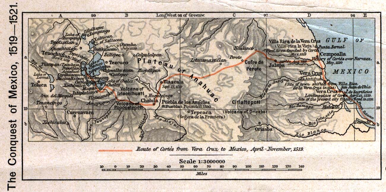
English: The 1519 to 1521 route of the Spanish conquest of the Aztec Empire — taken in Central Mexico by Hernando Cortés.
Français : La route de la conquête espagnole de l'Empire aztèque au centre de Mexique, comme suivi par Hernán Cortés de 1519 à 1521 |
| วันที่ | |
| แหล่งที่มา |
English: Scan from Historical Atlas by William R. Shepherd, New York, Henry Holt and Company, 1926 ed. Original image at the Perry-Castañeda Library Map Collection at the en:University of Texas at Austin website: http://www.lib.utexas.edu/maps/historical/shepherd/conquest_mexico_1519_21.jpg |
| ผู้สร้างสรรค์ | William R. Shepherd |
| การอนุญาต (การใช้ไฟล์นี้ใหม่) |
English: From the FAQ @ http://www.lib.utexas.edu/maps/faq.html
|
| เวอร์ชันอื่น |
|

การอนุญาตใช้สิทธิ
This file may not have the correct information on its copyright status.
Notify the uploader with:
Items tagged with this template are sorted into Category:Items with disputed copyright information.
|
ภาพหรือสื่อนี้เป็น สาธารณสมบัติ ในสหรัฐอเมริกา
ข้อความต่อไปนี้ใช้บังคับแก่ผลงานของสหรัฐอเมริกาที่หมดอายุการคุ้มครองทางลิขสิทธิ์แล้ว ซึ่งโดยมากเกิดจากการที่ภาพหรือสื่อนี้มี การตีพิมพ์เผยแพร่ครั้งแรก ก่อนวันที่ 1 มกราคม ค.ศ. 1929 (พ.ศ. 2472) สำหรับคำอธิบายเพิ่มเติม ดูที่ หน้านี้ |
 | |
 |
ภาพและสื่อนี้ อาจไม่เป็นสาธารณสมบัติ ในประเทศอื่นนอกเหนือจากประเทศสหรัฐอเมริกา โดยเฉพาะประเทศหรือดินแดนที่ไม่ได้บังคับใช้ กฎระยะเวลาคุ้มครองลิขสิทธิ์ที่สั้นกว่า สำหรับผลงานของสหรัฐอเมริกา เช่น แคนาดา จีนแผ่นดินใหญ่ (ไม่รวมฮ่องกงและมาเก๊า) เยอรมัน เม็กซิโกและสวิตเซอร์แลนด์ ดังนั้นผู้อัพโหลดจำเป็นต้องระบุข้อมูลเกี่ยวกับผู้สร้างสรรค์ภาพหรือสื่อนี้ และปีที่สร้างสรรค์ด้วย ดูเพิ่มที่ สาธารณสมบัติในวิกิพีเดีย และ ลิขสิทธิ์ในวิกิพีเดีย
|
บันทึกการอัพโหลด
The original description page was here. All following user names refer to en.wikipedia.
- 2006-12-18 21:20 Jengod 1300×649×8 (1520705 bytes) Scan from "Historical Atlas" by William R. Shepherd, New York, Henry Holt and Company, 1926 ed. Original image at the [http://www.lib.utexas.edu/maps/ Perry-Castañeda Library Map Collection] at the [[University of Texas at Austin]] website: http://www.l
ประวัติไฟล์
คลิกวันที่/เวลาเพื่อดูไฟล์ที่ปรากฏในขณะนั้น
| วันที่/เวลา | รูปย่อ | ขนาด | ผู้ใช้ | ความเห็น | |
|---|---|---|---|---|---|
| ปัจจุบัน | 03:12, 18 เมษายน 2551 | | 1,300 × 649 (1.45 เมกะไบต์) | File Upload Bot (Magnus Manske) | {{BotMoveToCommons|en.wikipedia}} {{Information |Description={{en|Scan from "Historical Atlas" by William R. Shepherd, New York, Henry Holt and Company, 1926 ed. Original image at the [http://www.lib.utexas.edu/maps/ Perry-Castañeda Library Map Collect |
หน้าที่มีภาพนี้
หน้าต่อไปนี้ โยงมาที่ภาพนี้:
การใช้ไฟล์ข้ามโครงการ
วิกิอื่นต่อไปนี้ใช้ไฟล์นี้:
- การใช้บน azb.wikipedia.org
- การใช้บน ca.wikipedia.org
- การใช้บน cs.wikipedia.org
- การใช้บน en.wikipedia.org
- การใช้บน es.wikipedia.org
- การใช้บน fa.wikipedia.org
- การใช้บน ja.wikipedia.org
- การใช้บน ms.wikipedia.org
- การใช้บน pnb.wikipedia.org
- การใช้บน sl.wikipedia.org
- การใช้บน tr.wikipedia.org
- การใช้บน uk.wikipedia.org
- การใช้บน ur.wikipedia.org
- การใช้บน vi.wikipedia.org
- การใช้บน www.wikidata.org