
ไฟล์:Concord Expedition and Patriot Messengers.jpg

ขนาดของตัวอย่างนี้: 800 × 341 พิกเซล ความละเอียดอื่น: 320 × 136 พิกเซล | 1,000 × 426 พิกเซล
ดูภาพที่มีความละเอียดสูงกว่า (1,000 × 426 พิกเซล, ขนาดไฟล์: 139 กิโลไบต์, ชนิดไมม์: image/jpeg)
| รูปภาพหรือไฟล์เสียงนี้ ต้นฉบับอยู่ที่ คอมมอนส์ รายละเอียดด้านล่าง เป็นข้อความที่แสดงผลจาก ไฟล์ต้นฉบับในคอมมอนส์
|

|
This file has been superseded by Concord Expedition and Patriot Messengers-en.svg. It is recommended to use the other file. Please note that deleting superseded images requires consent.
|

|
ภาพนี้มีภาพในรูปแบบเวกเตอร์ (SVG)
หากภาพ SVG ทำให้การแสดงผลดีกว่า หน้าที่ใช้ภาพนี้ควรเปลี่ยนไปใช้ภาพ SVG แทน File:Concord Expedition and Patriot Messengers.jpg → File:Concord Expedition and Patriot Messengers-en.svg
สำหรับข้อมูลเพิ่มเติมเกี่ยวกับภาพเวกเตอร์ ดูที่ การเปลี่ยนไปใช้ภาพ SVG ในคอมมอนส์ นอกจากนี้สามารถดูเพิ่มเติมเกี่ยวกับ ข้อมูลเกี่ยวกับการรองรับภาพ SVG สำหรับซอฟต์แวร์มีเดียวิกิ ได้ |
 |
ความย่อ
| ชื่อเรื่อง |
อังกฤษ:
Routes of the British Expedition and the Patriot Messengers |
||||||||||||||||||||
| คำอธิบาย |
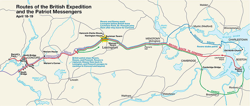
Paul Revere's Midnight Ride English: This is a map depiction the outbound routes taken by Patriot riders and British troops in the Battles of Lexington and Concord on April 19, 1775. |
||||||||||||||||||||
| คำอธิบายแผนที่ |
British route to Concord Revere's route Dawes' route Prescott's route |
||||||||||||||||||||
| วันที่ | ไม่ทราบวัน; source PDF was created in 2000 | ||||||||||||||||||||
| แหล่งที่มา | MIMAmap2.pdf 10 พฤษภาคม พ.ศ. 2548 (upload date) โดย w:Flying Jazz (คุย | ส่วนร่วม) | ||||||||||||||||||||
| ผู้สร้าง |
Unknown author for National Park Service |
||||||||||||||||||||
| Geotemporal data | |||||||||||||||||||||
| Date depicted | |||||||||||||||||||||
| พิกัดแผนที่ | บอสตัน, รัฐแมสซาชูเซตส์ | ||||||||||||||||||||
| ชนิดของแผนที่ | thematic map | ||||||||||||||||||||
| ส่วนหัวของแผนที่ |
 |
||||||||||||||||||||
| พิกัดอ้างอิงทางภูมิศาสตร์ | ถ้ามีความไม่เหมาะสม กรุณาตั้ง warp_status = skip เพื่อซ่อน | ||||||||||||||||||||
| Bibliographic data | |||||||||||||||||||||
| ผู้เผยแพร่ |
National Park Service |
||||||||||||||||||||
| Archival data | |||||||||||||||||||||
| Collection |
|
||||||||||||||||||||
| คำจารึก หรือคำที่ปรากฏในเนื้องาน |
ชื่อเรื่อง : Routes of the British Expedition and the Patriot Messengers
Text :
Revere and Dawes reach Lexington before British leave Lechmere Point. Dr. Prescott joins them after they leave for Concord.
Text :
British patrol stops Revere, Dawes, and Prescott. Revere is captured, Dawes flees back to Lexington, and Prescott escapes to continue to Concord and beyond.
|
||||||||||||||||||||
| เวอร์ชันอื่น |
|
||||||||||||||||||||


การอนุญาตใช้สิทธิ
| This image or media file contains material based on a work of a National Park Service employee, created as part of that person's official duties. As a work of the U.S. federal government, such work is in the public domain in the United States. See the NPS website and NPS copyright policy for more information. |
บันทึกการอัพโหลด
นำเข้าจาก en.wikipedia มายังคอมมอนส์ โดย Andrei Stroe โดยใช้ CommonsHelper
The original description page was here. All following user names refer to en.wikipedia.
- 2005-05-10 09:58 Flying Jazz 1000×426× (141988 bytes) Routes of the British Expedition and the Patriot Messengers April 18-19 (1775) Minute Man National Historical Park Battle Map http://data2.itc.nps.gov/parks/mima/ppMaps/MIMAmap2.pdf {{PD-USGov-Interior-NPS}}
- 2005-05-10 09:54 Flying Jazz 1000×426× (141988 bytes) Minute Man National Historical Park Battle Map http://data2.itc.nps.gov/parks/mima/ppMaps/MIMAmap2.pdf {{PD-USGov-Interior-NPS}}
ประวัติไฟล์
คลิกวันที่/เวลาเพื่อดูไฟล์ที่ปรากฏในขณะนั้น
| วันที่/เวลา | รูปย่อ | ขนาด | ผู้ใช้ | ความเห็น | |
|---|---|---|---|---|---|
| ปัจจุบัน | 03:50, 23 พฤศจิกายน 2553 | | 1,000 × 426 (139 กิโลไบต์) | File Upload Bot (Magnus Manske) | {{BotMoveToCommons|en.wikipedia|year={{subst:CURRENTYEAR}}|month={{subst:CURRENTMONTHNAME}}|day={{subst:CURRENTDAY}}}} {{Information |Description={{en|This is a map depiction the outbound routes taken by Patriot ride |
หน้าที่มีภาพนี้
หน้าต่อไปนี้ โยงมาที่ภาพนี้:
การใช้ไฟล์ข้ามโครงการ
วิกิอื่นต่อไปนี้ใช้ไฟล์นี้:
- การใช้บน azb.wikipedia.org
- การใช้บน cs.wikipedia.org
- การใช้บน en.wikipedia.org
- การใช้บน fr.wikipedia.org
- การใช้บน it.wikipedia.org
- การใช้บน ro.wikipedia.org
- การใช้บน ru.wikipedia.org
- การใช้บน zh.wikipedia.org