
ไฟล์:China Hong Kong 4 levels localisation.svg

ขนาดของตัวอย่าง PNG นี้ของไฟล์ SVG นี้: 705 × 599 พิกเซล ความละเอียดอื่น: 282 × 240 พิกเซล | 565 × 480 พิกเซล | 904 × 768 พิกเซล | 1,205 × 1,024 พิกเซล | 2,409 × 2,048 พิกเซล | 1,000 × 850 พิกเซล
ดูภาพที่มีความละเอียดสูงกว่า ((ไฟล์ SVG, 1,000 × 850 พิกเซล, ขนาดไฟล์: 703 กิโลไบต์))
| รูปภาพหรือไฟล์เสียงนี้ ต้นฉบับอยู่ที่ คอมมอนส์ รายละเอียดด้านล่าง เป็นข้อความที่แสดงผลจาก ไฟล์ต้นฉบับในคอมมอนส์
|
| คำอธิบาย |
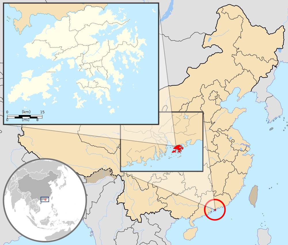
English: Map showing Hong Kong's location in Asia, on China's south coast, and Hong Kong's 18 districts
Français : Carte de Hong Kong : situation en Asie, situation sur le littoral chinois, carte des 18 districts
中文(繁體):顯示香港在亞洲,中國南海岸和香港18區的位置的地圖 |
| วันที่ | (UTC) |
| แหล่งที่มา |
ไฟล์ภาพกราฟิกส์เวกเตอร์ไม่ได้ระบุการตรวจโดย W3C นี้ สร้างขึ้นโดยใช้ Inkscape . |
| ผู้สร้างสรรค์ |
|
| เวอร์ชันอื่น | ไฟล์อื่นที่ใช้ไฟล์นี้: Hebao island map.jpg |
| ภาพนี้ ได้รับการปรับแต่งภาพ ซึ่งหมายความว่าจะได้รับการเปลี่ยนแปลงภาพต่างจากต้นฉบับ การปรับปรุง: Combination, color correction. ต้นฉบับสามารถดูได้ที่นี่: China Hong Kong.svg. ปรับแต่งภาพโดย Pethrus.
|
ไฟล์นี้อยู่ภายใต้สัญญาอนุญาต ครีเอทีฟคอมมอนส์ แบบแสดงที่มา-อนุญาตแบบเดียวกัน 3.0 ต้นฉบับ
การแสดงที่มา: GFDL
- คุณสามารถ:
- ที่จะแบ่งปัน – ที่จะทำสำเนา แจกจ่าย และส่งงานดังกล่าวต่อไป
- ที่จะเรียบเรียงใหม่ – ที่จะดัดแปลงงานดังกล่าว
- ภายใต้เงื่อนไขต่อไปนี้:
- แสดงที่มา – คุณต้องให้เกียรติเจ้าของงานอย่างเหมาะสม โดยเพิ่มลิงก์ไปยังสัญญาอนุญาต และระบุหากมีการเปลี่ยนแปลง คุณอาจทำเช่นนี้ได้ในรูปแบบใดก็ได้ตามควร แต่ต้องไม่ใช่ในลักษณะที่แนะว่าผู้ให้อนุญาตสนับสนุนคุณหรือการใช้งานของคุณ
- อนุญาตแบบเดียวกัน – หากคุณดัดแปลง เปลี่ยนรูป หรือต่อเติมงานนี้ คุณต้องใช้สัญญาอนุญาตแบบเดียวกันหรือแบบที่เหมือนกับสัญญาอนุญาตที่ใช้กับงานนี้เท่านั้น
บันทึกการอัพโหลด
This image is a derivative work of the following images:
- File:Hong_Kong_Location.svg licensed with PD-self
- 2008-08-27T13:27:11Z Joowwww 1270x640 (234741 Bytes) a few minor tweaks
- 2008-08-27T13:18:03Z Joowwww 1270x640 (234389 Bytes) new version: more detailed, colours are standard with most other locator maps
- 2008-04-20T13:54:51Z Joowwww 1270x640 (79729 Bytes) reduced height, removed map border and added rivers and hk's maritime border
- 2008-04-09T11:31:22Z Joowwww 1270x977 (66085 Bytes) {{Information |Description=A map showing Hong Kong's location in Asia, in China and on China's south coast. |Source=self-made |Date=2008-04-09 |Author= [[User:Joowwww|Joowwww]] |Permission={{PD-self}} |other_versions= }} {{Cr
- File:Map_of_Hong_Kong_18Districts_ZH.svg licensed with Cc-by-sa-3.0, GFDL
- 2008-07-05T21:14:26Z Moddlyg 1454x1083 (381097 Bytes) == Summary == {{Information |Description={{en|1=Map of Hong Kong & 18 Districts (Chinese Version)}} |Source=Own work by uploader |Author={{User:Moddlyg/Sign}} |Date=2008/7/6 |Permission= |other_versions= }} {{ImageUpload|ful
- 2008-07-05T20:59:35Z Moddlyg 1454x1083 (262750 Bytes) {{Information |Description={{en|1=Map of Hong Kong & 18 Districts (Chinese Version)}} |Source=Own work by uploader |Author=~~~ |Date=2008/7/6 |Permission= |other_versions= }}
- File:China_Hong_Kong.svg licensed with PD-self
- 2008-08-13T16:22:08Z Joowwww 1000x850 (212124 Bytes) added missing laos/vietnam border
- 2008-05-14T11:14:46Z Joowwww 1000x850 (210515 Bytes) {{Information |Description=An SVG map of China with Hong Kong special administrative region highlighted and circled Legend:[[Image:China map legend.png]] |Source=self-made; based on CIA public domain maps: *http://www.lib.ut
Uploaded with derivativeFX
ประวัติไฟล์
คลิกวันที่/เวลาเพื่อดูไฟล์ที่ปรากฏในขณะนั้น
| วันที่/เวลา | รูปย่อ | ขนาด | ผู้ใช้ | ความเห็น | |
|---|---|---|---|---|---|
| ปัจจุบัน | 04:33, 23 กันยายน 2562 | | 1,000 × 850 (703 กิโลไบต์) | En rouge | added map scale, for the higher resolution sub-picture |
| 14:57, 14 พฤษภาคม 2558 |  | 1,000 × 850 (686 กิโลไบต์) | Flappiefh | Fixed colour of Haïnan. | |
| 01:40, 6 มีนาคม 2553 |  | 1,000 × 850 (685 กิโลไบต์) | Pethrus | {{Information |Description={{en|1=Map showing Hong Kong's location in Asia, on China's south coast, and Hong Kong's 18 disctricts}} {{fr|1=Carte de Hong Kong : situation en Asie, situation sur le littoral chinois, carte des 18 disctricts}} |Source=*[[:Fil |
หน้าที่มีภาพนี้
ไม่มีหน้าใดโยงมาที่ภาพนี้
การใช้ไฟล์ข้ามโครงการ
วิกิอื่นต่อไปนี้ใช้ไฟล์นี้:
- การใช้บน ami.wikipedia.org
- การใช้บน as.wikipedia.org
- การใช้บน azb.wikipedia.org
- การใช้บน bh.wikipedia.org
- การใช้บน bo.wikipedia.org
- การใช้บน br.wikipedia.org
- การใช้บน cbk-zam.wikipedia.org
- การใช้บน dty.wikipedia.org
- การใช้บน dz.wikipedia.org
- การใช้บน en.wikipedia.org
- การใช้บน fi.wikipedia.org
- การใช้บน fr.wikipedia.org
- การใช้บน fr.wikinews.org
- การใช้บน fr.wiktionary.org
- การใช้บน fur.wikipedia.org
- การใช้บน gcr.wikipedia.org
- การใช้บน gn.wikipedia.org
- การใช้บน incubator.wikimedia.org
- การใช้บน io.wikipedia.org
- การใช้บน it.wikipedia.org
- การใช้บน ja.wikipedia.org
- การใช้บน li.wikipedia.org
- การใช้บน lld.wikipedia.org
- การใช้บน lo.wikipedia.org
- การใช้บน mad.wikipedia.org
- การใช้บน mai.wikipedia.org
ดูการใช้ข้ามโครงการเพิ่มเติมของไฟล์นี้