
ไฟล์:Bevölkerungsprognosen Cottbus.pdf

ขนาดของตัวอย่าง JPG นี้ของไฟล์ PDF นี้: 800 × 566 พิกเซล ความละเอียดอื่น: 320 × 226 พิกเซล | 640 × 453 พิกเซล | 1,024 × 724 พิกเซล | 1,280 × 905 พิกเซล | 1,752 × 1,239 พิกเซล
ดูภาพที่มีความละเอียดสูงกว่า (1,752 × 1,239 พิกเซล, ขนาดไฟล์: 68 กิโลไบต์, ชนิดไมม์: application/pdf)
| รูปภาพหรือไฟล์เสียงนี้ ต้นฉบับอยู่ที่ คอมมอนส์ รายละเอียดด้านล่าง เป็นข้อความที่แสดงผลจาก ไฟล์ต้นฉบับในคอมมอนส์
|

|
ภาพกราฟนี้ ควรจะถูกสร้างใหม่เป็นกราฟิกส์เวกเตอร์ ซึ่งมีข้อดีอีกหลายประการ ดูเพิ่มเติมที่คอมมอนส์:สื่อต้องการเก็บกวาดสำหรับสารสนเทศเพิ่มเติม หากภาพนี้มีในรูปแบบกราฟิกส์เวกเตอร์อยู่แล้ว กรุณาอัปโหลดและแทนที่แม่แบบนี้ด้วย
{{vector version available|ชื่อภาพใหม่}}
แนะนำเป็นอย่างยิ่งให้ตั้งชื่อไฟล์เวกเตอร์ใหม่นั้นในรูปแบบ "Bevölkerungsprognosen Cottbus.svg" แล้วใส่แม่แบบ Vector version available (หรือ Vva) ซึ่งไม่ต้องใช้พารามิเตอร์ ชื่อภาพใหม่ |
ความย่อ
| คำอธิบาย |
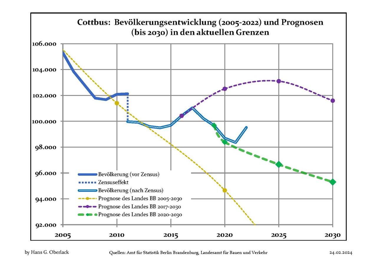
Deutsch: Aktuelle Bevölkerungsentwicklung (blaue Linien) und Prognosen (punktierte Linien) für Cottbus , Landkreis Cottbus, Land Brandenburg, Deutschland
English: Recent population development (blue lines) and projections (dotted lines) of Cottbus, Cottbus district, Brandenburg state, Germany
Español: Tendencias actuales (lineas azules) y previsiones (lineas de puntos) de la poblacion de Cottbus, distrito de Cottbus, estado de Brandenburg, Alemania
Français : Évolution actuelle de la population (lignes bleues) et projections démographiques (lignes pointillées) de Cottbus, arrondissement de Cottbus, Land de Brandebourg, Allemagne
Italiano: Sviluppo recente della popolazione (linea blu) e previsioni demografiche (linea puntata) de Cottbus, circondario de Cottbus, stato federato de Brandeburgo, Germania
Nederlands: Recente ontwikkeling van de bevolking (blauwe lijn) en prognoses (stippelijn) van Cottbus, landkreis Cottbus, deelstaat Brandenburg, Duitsland
Polski: Obecne tendencje (niebieska linia) i prognozy demograficzne (linia przerywana) dla Cottbus, powiat Cottbus, kraj Brandenburgia, Niemcy
Svenska: Aktuella befolkningsutveckling (blå linjen) och prognoser (prickade linjen) av Cottbus, landkreis Cottbus, delstaten Brandenburg, Tyskland |
| วันที่ | 18 มีนาคม พ.ศ. 2555 - 24 กุมภาพันธ์ พ.ศ. 2567 |
| แหล่งที่มา | Own work based on: Data sources displayed at Population Projection Brandenburg at Wikimedia Commons |
| ผู้สร้างสรรค์ | Hans G. Oberlack |
| Latest population data | 2022 |
| Latest population forecast | LBV 2020-2030 |
| Type of municipality | kreisfrei |
| ตำแหน่งของวัตถุหรือสถานที่ | | ภาพนี้และภาพอื่น ๆ ณ สถานที่เดียวกันที่ OpenStreetMap |
|---|
การอนุญาตใช้สิทธิ
ข้าพเจ้า ในฐานะผู้ถือลิขสิทธิ์ของภาพหรือสื่อนี้ อนุญาตให้ใช้ภาพหรือสื่อนี้ภายใต้เงื่อนไขต่อไปนี้
ไฟล์นี้อยู่ภายใต้สัญญาอนุญาต ครีเอทีฟคอมมอนส์ แบบแสดงที่มา-อนุญาตแบบเดียวกัน 3.0 ต้นฉบับ
- คุณสามารถ:
- ที่จะแบ่งปัน – ที่จะทำสำเนา แจกจ่าย และส่งงานดังกล่าวต่อไป
- ที่จะเรียบเรียงใหม่ – ที่จะดัดแปลงงานดังกล่าว
- ภายใต้เงื่อนไขต่อไปนี้:
- แสดงที่มา – คุณต้องให้เกียรติเจ้าของงานอย่างเหมาะสม โดยเพิ่มลิงก์ไปยังสัญญาอนุญาต และระบุหากมีการเปลี่ยนแปลง คุณอาจทำเช่นนี้ได้ในรูปแบบใดก็ได้ตามควร แต่ต้องไม่ใช่ในลักษณะที่แนะว่าผู้ให้อนุญาตสนับสนุนคุณหรือการใช้งานของคุณ
- อนุญาตแบบเดียวกัน – หากคุณดัดแปลง เปลี่ยนรูป หรือต่อเติมงานนี้ คุณต้องใช้สัญญาอนุญาตแบบเดียวกันหรือแบบที่เหมือนกับสัญญาอนุญาตที่ใช้กับงานนี้เท่านั้น
ประวัติไฟล์
คลิกวันที่/เวลาเพื่อดูไฟล์ที่ปรากฏในขณะนั้น
| วันที่/เวลา | รูปย่อ | ขนาด | ผู้ใช้ | ความเห็น | |
|---|---|---|---|---|---|
| ปัจจุบัน | 20:06, 24 กุมภาพันธ์ 2567 |  | 1,752 × 1,239 (68 กิโลไบต์) | Hans G. Oberlack | 2020, 2021 and 2022 data added |
| 05:16, 24 กันยายน 2565 |  | 1,752 × 1,239 (125 กิโลไบต์) | Hans G. Oberlack | 2021 data added | |
| 02:26, 1 สิงหาคม 2564 |  | 1,752 × 1,239 (124 กิโลไบต์) | Hans G. Oberlack | New official forecast and 2020 data added | |
| 23:06, 23 สิงหาคม 2563 | 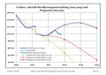 | 1,752 × 1,239 (124 กิโลไบต์) | Hans G. Oberlack | 2019 data added | |
| 04:58, 29 กรกฎาคม 2562 |  | 1,752 × 1,239 (137 กิโลไบต์) | Hans G. Oberlack | 2018 data added | |
| 03:00, 9 มกราคม 2562 |  | 1,752 × 1,239 (125 กิโลไบต์) | Hans G. Oberlack | Latest official forecast added | |
| 05:28, 3 ตุลาคม 2561 |  | 1,752 × 1,239 (120 กิโลไบต์) | Hans G. Oberlack | 2017 data added | |
| 19:54, 14 มกราคม 2561 | 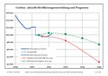 | 1,752 × 1,239 (118 กิโลไบต์) | Hans G. Oberlack | 2016 data added | |
| 06:29, 13 มกราคม 2560 |  | 1,752 × 1,239 (116 กิโลไบต์) | Hans G. Oberlack | New official forecast and 2015 figures added | |
| 16:24, 19 ตุลาคม 2557 |  | 1,752 × 1,239 (96 กิโลไบต์) | Hans G. Oberlack | 2013 data added |
หน้าที่มีภาพนี้
หน้าต่อไปนี้ โยงมาที่ภาพนี้:
การใช้ไฟล์ข้ามโครงการ
วิกิอื่นต่อไปนี้ใช้ไฟล์นี้:
- การใช้บน de.wikipedia.org
- การใช้บน en.wikipedia.org
- การใช้บน sco.wikipedia.org