
ไฟล์:Aerial-View-Minamitori-Island-1987.jpg

ขนาดของตัวอย่างนี้: 800 × 507 พิกเซล ความละเอียดอื่น: 320 × 203 พิกเซล | 640 × 405 พิกเซล | 1,024 × 649 พิกเซล | 1,280 × 811 พิกเซล | 2,824 × 1,789 พิกเซล
ดูภาพที่มีความละเอียดสูงกว่า (2,824 × 1,789 พิกเซล, ขนาดไฟล์: 1.09 เมกะไบต์, ชนิดไมม์: image/jpeg)
| รูปภาพหรือไฟล์เสียงนี้ ต้นฉบับอยู่ที่ คอมมอนส์ รายละเอียดด้านล่าง เป็นข้อความที่แสดงผลจาก ไฟล์ต้นฉบับในคอมมอนส์
|
ความย่อ
| คำอธิบาย |
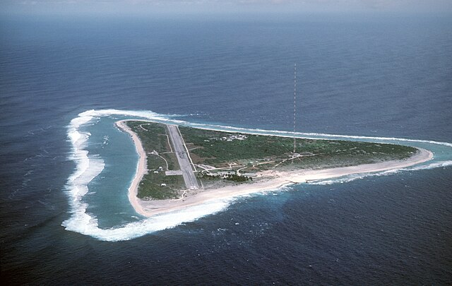
English: Aerial view of Minamitori Island (Minami-Torishima), Japan. There is a runway which supported the US Coast Guard station located there prior to 1993. Minamitori Island is the easternmost island of the Japanese archipelago.
Deutsch: Luftaufnahme der Minamitori Insel (Minami-Torishima), Japan.
日本語: 南鳥島の空中写真。 |
|||
| วันที่ | ||||
| แหล่งที่มา |
|
|||
| ผู้สร้างสรรค์ | Chief Master Sergeant Don Sutherland, U.S. Air Force |
การอนุญาตใช้สิทธิ
ภาพหรือสื่อต่อไปนี้ถ่ายหรือจัดทำขึ้นในระหว่างการปฏิบัติหน้าที่ราชการของข้าราชการประจำกองทัพสหรัฐอเมริกา หรือข้าราชการประจำกระทรวงกลาโหมสหรัฐอเมริกา ภาพหรือสื่อดังกล่าวจึงจัดเป็นงานของรัฐบาลกลางสหรัฐอเมริกา และถือเป็นสาธารณสมบัติ
ดูเพิ่มที่ http://www.defenselink.mil/multimedia/about.html
|
 |
ประวัติไฟล์
คลิกวันที่/เวลาเพื่อดูไฟล์ที่ปรากฏในขณะนั้น
| วันที่/เวลา | รูปย่อ | ขนาด | ผู้ใช้ | ความเห็น | |
|---|---|---|---|---|---|
| ปัจจุบัน | 08:38, 18 มกราคม 2550 | | 2,824 × 1,789 (1.09 เมกะไบต์) | Balcer~commonswiki | ID: DFST8708298 Service Depicted: Coalition or Allied Forces Aerial view of Marcus Island and the runway which supports the US Coast Guard station located there. Marcus Island is the southernmost island in the Japanese chain. Camera Operator: CMSGT |
หน้าที่มีภาพนี้
หน้าต่อไปนี้ โยงมาที่ภาพนี้:
การใช้ไฟล์ข้ามโครงการ
วิกิอื่นต่อไปนี้ใช้ไฟล์นี้:
- การใช้บน ar.wikipedia.org
- การใช้บน ast.wikipedia.org
- การใช้บน az.wikipedia.org
- การใช้บน be.wikipedia.org
- การใช้บน ca.wikipedia.org
- การใช้บน ceb.wikipedia.org
- การใช้บน cs.wikipedia.org
- การใช้บน de.wikipedia.org
- การใช้บน el.wikipedia.org
- การใช้บน en.wikipedia.org
- การใช้บน es.wikipedia.org
- การใช้บน et.wikipedia.org
- การใช้บน eu.wikipedia.org
- การใช้บน fa.wikipedia.org
- การใช้บน fi.wikipedia.org
- การใช้บน frr.wikipedia.org
- การใช้บน fr.wikipedia.org
- การใช้บน fr.wiktionary.org
- การใช้บน gl.wikipedia.org
- การใช้บน hy.wikipedia.org
- การใช้บน it.wikipedia.org
- การใช้บน ja.wikipedia.org
ดูการใช้ข้ามโครงการเพิ่มเติมของไฟล์นี้